Technology is furthering innovation in wildland firefighting across the west, including the Tahoe Basin — and not just in the process of extinguishing flames but in prevention of these catastrophic burns. Last fall, researchers at the University of Nevada, Reno, kicked off a series of projects that seek to map out the vegetation in the forests across California, especially the ladder fuels that carry low-intensity fires from the ground to the canopies of the trees. Crown fires are the most intense type of fire, difficult to contain and extremely dangerous for firefighting crews on the ground. Named after the term for blazes reaching 1 million acres, the GigaFire Project is creating a statewide map that will help land managers identify where fire risk is the greatest and determine which of the fuel reduction methods will be most effective in a specific area.
Though mapping of tree density is not a new practice, a project of this scale — and one that is able to factor in the ladder fuels hidden beneath the canopy of trees — is invaluable for the future of firefighting. “Ladder fuels are the part of a forest that people very poorly understand where the fuels are at scale,” notes Greenberg. The researchers combine data from satellites already in orbit with aerial LiDAR (Light Detecting And Ranging), which can map the ladder fuels through the canopy, and ground-based laser scans. Computer modeling fills in the gaps. “We combine what we can see with what we can’t see by using simulations based on our understanding of how fuels accumulate over time,” says Greenberg. The analysis of all of this data at the scale of the entire state of California has required the aid of Google and ACCESS supercomputing centers. “This is a big data problem,” explains Greenberg. “If you ran it on a single computer with a single processor it would take about 700 years to run all of the calculations.”
The GigaFire project is funded jointly by the California Air Resource Board and CAL FIRE. Forecasting of fires based on factors like fuel density and moisture, topography and weather is an important technological tool in CAL FIRE’s arsenal against wildfire. “[The computer program] runs thousands of fires over the terrain in a given simulation and it gives an output of what all of those would look like combined into one scenario,” explains Brian Newman, Assistant Chief with CAL FIRE’s Amador-El Dorado Unit. “It gives us the ability to make good decisions based on where a fire is going, how fast it’s burning and make better decisions about where to put resources, what types of resources and what communities might be affected.”
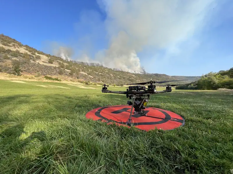
“How long it would take to burn to specific area? What would the flame lengths be? How intense would it be? Would it lead to a crown fire or spotting? It really gives a good assessment of the potential of the fire,” adds Newman. In 2021, CAL FIRE also standardized a drone program across its units. With an 8-foot span, the drones are flown over fires, day or night, and can collect thermal imaging, use LiDAR for 3D modeling, and regular video footage to assess the fire. The drones can also be used for aerial ignition for a controlled burn or to burn out fuel between the main encroaching fire and the control line. A small chemical-filled sphere is injected with a reagent as it’s released by the drone, causing the sphere to catch fire as it nears the ground. It reduces the risk of people doing this from a helicopter or on the ground.