A modern, sustainable society depends on the mining industry to supply crucial materials. Batteries and electric vehicles require metals like lithium and cadmium, wind turbines require rare earth metals and our cities need aggregate materials like gravel and sand for construction. On the other hand, the mining industry also produces materials like coal which are detrimental to a low-carbon future. As the industry evolves to meet changing demands for raw materials, tens to hundreds of thousands of landscapes around the world are changing. But can we measure this impact and confidently weigh up the pros and cons of mining activities? The mining industry remains hugely controversial, so independent research can play a critical role in measuring the human and environmental impacts of mining activities, as well as tracking progress as the industry evolves.
Mines are often easy to spot in satellite imagery, and this has led to a growing body of research exploring the impacts of mining from what can be seen from above. For example, in 2019 we began examining satellite images of nickel mining regions in Indonesia (the world’s leading producer of nickel, needed for battery technologies) and we spotted a large, heavily-impacted area. From space, the view is dramatic, but we wanted to know more about what these images tell us about what is happening on the ground. This site hosts a mixture of formal and informal (or illegal) mining and shows evidence of extensive land clearing in a highly biodiverse region. However, some of the companies operating in this area produce no public reports.
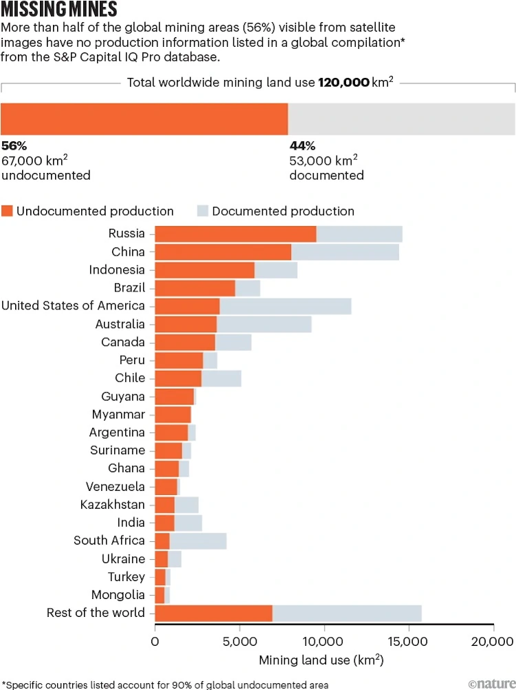
Others produce reports that contain barely any data on production or impacts. This led us to wonder – how much of the world’s mining impacts are actually measured? To answer this, we have spent the last five years manually scanning global satellite imagery to visually identify and delineate mine areas. We identified around 120,000 square kilometres of features like tailings dams, pits and waste rock dumps around the world. These features occupy all kinds of ecosystems and landscapes and take a wide variety of forms. Our latest research, published in Nature, compares our satellite imagery with the S&P Capital IQ Pro database, a global mining database used in virtually every global-scale study of mining impacts. To our surprise, we found that more than half of the areas identified in satellite imagery had no corresponding production information in the database.
This lack of data could be due to companies not reporting anything (a huge portion of global mining activity might be illegal) and there are likely many abandoned sites that wouldn’t have a company to report on them. However, it’s also clear that information gaps exist even in countries like Australia with heavily regulated mining industries. Around 3600 square kilometres, or 39 per cent of the visible mining footprint in Australia has no production data in the S&P database. This shows that the massive task of collecting reports produced by mining companies simply isn’t finished. As researchers, we often have no choice but to rely on these incomplete databases, as the job of independently gathering data is massive. It can easily take hours to find information on a single mine.