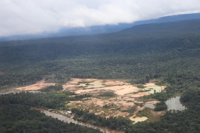
Flying over a dense jungle in southern Venezuela, the sea of trees below is suddenly replaced by large patches of bare soil, tree stumps and the turquoise waters of ponds from abandoned gold mines. An airstrip 600 meters long marks the entrance to one of Venezuela’s more than 3,700 gold mines. Only half of the runway is used for landing and taking off, as the rest of the dirt track is in poor condition. A 2022 report by the Venezuelan investigative journalism group Armando.info and the Spanish newspaper El País, supported by the Pulitzer Center Rainforest Investigations Network and the Norwegian digital agency Earthrise Media, called Corredor Furtivo, used satellite imagery and artificial intelligence to identify more than 3,700 mining sites and 42 airstrips in the Venezuelan states of Bolívar and Amazonas. They found that at the time of the research, new runways had been developed between 2015 and 2020, and that Brazilian garimpeiros (gold miners) had returned to the south of the Venezuelan Amazon. The Corredor Furtivo team is not the only one that has used satellite imagery, crowdsourced databases and geospatial analysis to detect hidden runways in the Amazon Basin. In a project by the New York Times, The Intercept Brasil and the Rainforest Investigations Network, reporters identified more than 1,200 unregistered airstrips throughout the Brazilian Amazon. Both studies highlighted the substantial deforestation linked to these airstrips. In Venezuela, the network of airstrips may be much larger than what can be observed on existing maps. SOS Orinoco, an investigative group focused on the human and environmental effects of gold mining in Venezuela, has created a Geoportal that documents 117 runways in Venezuela.