Real-time crop monitoring has become increasingly important, particularly for addressing climate-induced losses and damages, as discussed during the last United Nations Framework Convention on Climate Change (UNFCCC) Conference of the Parties (CoP27).
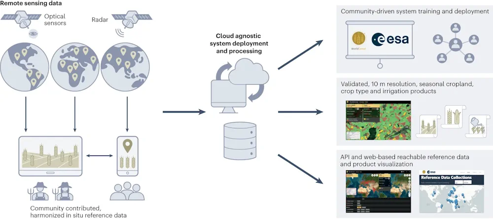
Initiatives like GEOGLAM and the Agricultural Market Information System (AMIS) have traditionally contributed to monitoring global food security by relying on existing data about crop locations and agricultural productivity. However, these systems often provide static information based on past data at a coarse resolution. To address current limitations and advance real-time, global-scale crop monitoring, the WorldCereal project has created an open-source, highly scalable system.
This system utilizes openly available Sentinel-1 and 2 satellite data provided by the EU Copernicus program, which offer high spatial and temporal resolution (10 m resolution with revisit times of five days or less). In 2021, the system demonstrated its capability to provide seasonal cropland information, crop-specific maps for maize and cereals, and irrigation maps.
In their paper published in Nature Food, IIASA researcher Linda See and colleagues from ESA, the Flemish Institute for Technological Research’s VITO Remote Sensing, Stellenbosch University, and the Food and Agriculture Organization of the United Nations (FAO), highlight the potential for the system to incorporate greater crop-specific data, thereby boosting the accuracy of subnational and national agricultural statistics.
A key innovation of the project is its community-based, open, and harmonized global reference database, which contains 75 million samples from 2017 onwards, which was contributed by many different organizations and individual projects worldwide.