British investment firm Seraphim Space surveyed the Earth observation sector a few years ago, categorizing startups by sensor type. Analysts determined that firms focused on electro-optical and synthetic aperture radar were advancing rapidly. Thermal imagery startups were not.
“Much to our surprise, it was the only sensor area that didn’t have any companies that had really progressed,” said Seraphim Space CEO Mark Boggett. “None of the companies had raised $10 million, let alone $100 million or $500 million like some of the other sensor areas.” All that is changing. Startups focused on gathering thermal imagery via satellite are attracting investment, making acquisitions and winning contracts. “It’s the next big thing in Earth observation,” said Anthony Baker, founder and CEO of Satellite Vu, a British Earth-observation startup. “No one has opened up the frontier on infrared.”
The new businesses focused on thermal imagery vary widely. What the founders share is the conviction that startups can provide the type of data only expensive government satellites supplied in the past. “There’s an urgency to do something,” said Max Gulde, CEO and co-founder of German startup constellr. “Having a thermal picture of our planet at an actionable resolution and frequency is something which is missing in our understanding of climate change. Suddenly, there’s a push for that.” Thermal imagery startups also are benefiting from recent declines in launch costs and technological advances. “When I started founding the company, everyone was explaining to me that the sensor we wanted to build was impossible,” said Thomas Grübler, CEO and co-founder of Munich-based OroraTech. “Now, it’s possible to shrink these big complex systems to smallsat and cubesat scale.”
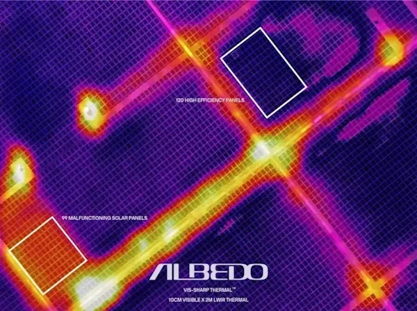
When Albedo, a Colorado startup, was founded in 2020, the business plan focused on collecting 10-centimeter-resolution optical imagery from telescopes in very low Earth orbit. The founders soon realized they could obtain longwave infrared imagery from the same satellites without much additional cost. “With the optical resolution, we can go from counting cars to identifying cars,” said Albedo founder and CEO Topher Haddad. “With thermal, you can see where a car probably just pulled out from a parking spot.” Plus, the combination of optical and thermal imagery helps observers distinguish hot tubs from pools or trampolines, and backyard dwelling units from sheds.
Constellr is preparing to launch satellites in 2024 to gather thermal data for agricultural and environmental-monitoring applications. Earlier this year, constellr acquired ScanWorld, a Belgian hyperspectral satellite imagery and analytics startup. With four shoebox-size satellites equipped with infrared sensors, constellr plans to gather daily imagery of agricultural fields around the world. By adding hyperspectral data, constellr can help farmers identify crop disease and manage fertilization schedules.
Washington-based Hydrosat has raised $35.6 million to obtain thermal data from space. Supporting sustainable agriculture and helping customers reduce carbon emissions are the company’s primary goals. Thermal data can pick up initial signs of drought two to four weeks before optical imagery shows a change in the color of vegetation, said Pieter Fossel, Hydrosat CEO and co-founder.
Constellr is preparing to launch satellites in 2024 to gather thermal data for agricultural and environmental-monitoring applications. Earlier this year, constellr acquired ScanWorld, a Belgian hyperspectral satellite imagery and analytics startup. With four shoebox-size satellites equipped with infrared sensors, constellr plans to gather daily imagery of agricultural fields around the world. By adding hyperspectral data, constellr can help farmers identify crop disease and manage fertilization schedules.