Geomaticians

Urban

PBH Apresenta Base De Dados Urbanos Em Evento Diálogos Urbanos

PBH Apresenta Base De Dados Urbanos Em Evento Diálogos Urbanos

A Prefeitura de Belo Horizonte realizará nesta quarta-feira (27), às 14h, no Teatro Francisco Nunes, o evento Diálogos Urbanos para apresentar as plataformas de dados públicos sobre o planejamento urbano da capital. A intenção é publicizar as ferramentas e permitir a participação da sociedade nas discussões. O evento é destinado a professores, estudantes, pesquisadores e ...
prefeitura.pbh.gov.br
Merseyside Police Adopts Geospatial Technology To Support Crime Prevention

Merseyside Police Adopts Geospatial Technology To Support Crime Prevention

Merseyside Police is using technology to answer the “where and why” of serious violence across the region, to support crime prevention and to enhance public safety. Risk Terrain Modeling (RTM), powered by Simsi, focuses on places, not people, to prevent crime. Simsi is a startup out of Rutgers University in New Jersey. Analysts from Merseyside ...
merseyside.police.uk
Using Remote Sensing Technology To Measure Vehicle Emissions

Using Remote Sensing Technology To Measure Vehicle Emissions

While laboratory-based emissions testing can help keep polluting vehicles off the road, they alone are not enough. What is needed is new technologies, such as remote emission sensing (RES). RES uses sensors and cameras to automatically measure exhaust emissions from vehicles in real-world operation. While RES may be a proven technology, it is not widely ...
cordis.europa.eu

Dubai Municipality Launches Digital Platform Empowering Senior Leaders With Customer Requests

Dubai Municipality has launched an innovative ‘Services 360’ policy digital platform, leveraging cutting-edge technologies and Geographic Information System (GIS), to provide its senior leaders and executives with real-time insights into customer requests and communications. This innovative platform empowers executives to oversee the progress of specialised tasks, ensure adherence to the highest service standards, and accelerate ...
wam.ae

Esri Canada Acquires Ratio.City To Help Address Canada’s Housing Crisis

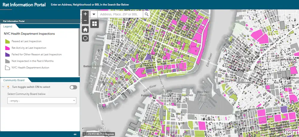
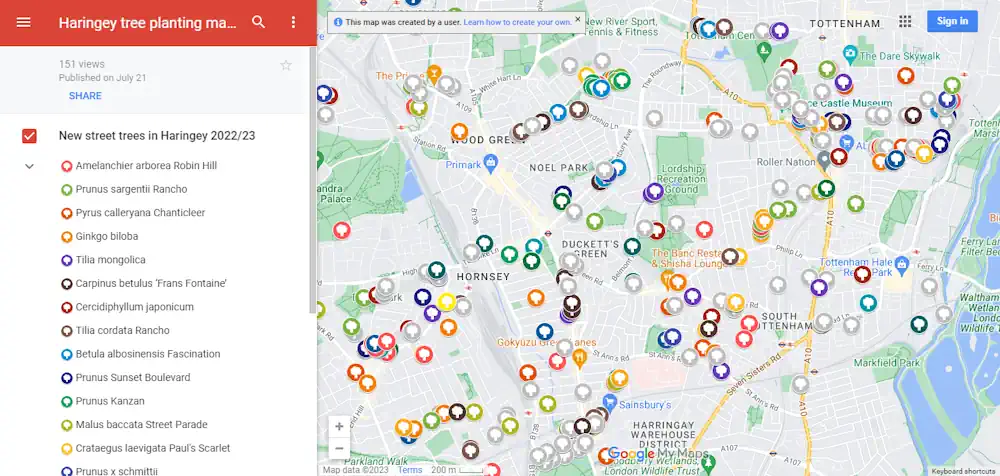
Esri Canada, today announced its acquisition of Ratio.City, a Toronto-based urban planning software and data company. This acquisition expands Esri Canada’s community planning solutions portfolio, enabling customers to better collaborate within the land development and planning community, and accelerating the design and approval of more affordable housing. “Ratio.City’s extensive expertise in planning, design and development ...
directionsmag.com
New Pittsburgh Database Can Help You Find Recycling Locations

사천시, 디지털트윈 스마트도시 구축 현실화

사천시가 지난 13일 한국국토정보공사(LX) 경남지역본부(본부장 배종욱)와 ‘디지털트윈 기반 스마트도시 구축을 위한 업무협약’을 체결했다고 14일 밝혔다. 양 기관은 이번 협약을 통해 디지털트윈(가상모형) 플랫폼 구축 및 서비스, 인프라 지원·협력과 3차원 데이터 구축 등에 대한 상호협력을 약속했다. 주요 내용은 △디지털트윈 기반 스마트도시 실현을 위한 정보 및 기술 공유 △한국국토정보공사(LX) 플랫폼 기반 행정 및 산업서비스 모델 공동 활용 △스마트 ...
gnmaeil.com
New Pittsburgh Database Can Help You Find Recycling Locations

New Pittsburgh Database Can Help You Find Recycling Locations

Responsible recycling in Allegheny County just got easier. County officials this week launched the Recycling Drop-Off Finder, an online database and map that identifies drop-off locations, including places to take hard-to-recycle items. The site, a collaboration between county health, sustainability and information technology departments, is now live. The tool will also be helpful for residents ...
pittsburghmagazine.com
Images Of Simulated Cities Help Artificial Intelligence To Understand Real Streetscapes

Images Of Simulated Cities Help Artificial Intelligence To Understand Real Streetscapes

Recent advances in artificial intelligence and deep learning have revolutionized many industries, and might soon help recreate your neighborhood as well. Given images of a landscape, the analysis of deep-learning models can help urban landscapers visualize plans for redevelopment, thereby improving scenery or preventing costly mistakes. To accomplish this, however, models must be able to ...
techxplore.com
Geoportal Und Stadtplan Überarbeitet

Geoportal Und Stadtplan Überarbeitet

Das Geoportal der Stadt Mannheim erscheint ab sofort in neuem Gewand und ist auf allen Endgeräten abrufbar. Federführend ist dabei nach Angaben der Kommune das Geodatenkompetenzzentrum im Fachbereich Geoinformation und Stadtplanung. „Im Sinne einer modernen Stadtverwaltung optimieren wir stetig unsere digitalen Angebote. Das Geoportal bietet kostenfrei und von überall zugänglich eine Vielzahl an nützlichen Informationen ...
kommune21.de
¿Sabías Que Hay Un Portal Web Con Más De 2.200 Datos Sobre Bogotá Conócelo Aquí

¿Sabías Que Hay Un Portal Web Con Más De 2.200 Datos Sobre Bogotá? Conócelo Aquí

El portal web Datos Abiertos Bogotá es una plataforma digital que reúne un vasto y diverso conjunto de datos geográficos y alfanuméricos que pueden ser útiles para investigadores, docentes, veedores, estudiantes y ciudadanía, interesados en explorar el pulso de la ciudad. El portal alberga una colección de más de 2.200 conjuntos de datos, publicados de ...
bogota.gov.co

First Atlas Of Urban Nighttime Light Remote-Sensing Data Unveiled

The International Research Center of Big Data for Sustainable Development Goals (CBAS) has released the world’s first atlas of urban nighttime light remote-sensing data, providing support for the research on urban sustainable development. The atlas contains 10-meter resolution nighttime light data on 147 cities in 105 countries around the world. The data was captured by ...
english.news.cn

Chicago Uses Tech, Resident Input To Improve Services

The map-based Chicago Recovery Plan was created with feedback from residents. It also allows them to track progress on city projects to create safe neighborhoods and drive equitable economic growth. Launched in May 2023, the tool is “opening the books on neighborhood investments in a simple, accessible digital format,” Chief Technology Officer Nick Lucius said ...
govtech.com
El Mapa De Calor Del Ayuntamiento De Madrid Descubre Si Vives En Una Zona Con Temperaturas “Extremadamente Altas”

El Mapa De Calor Del Ayuntamiento De Madrid: Descubre Si Vives En Una Zona Con Temperaturas “Extremadamente Altas”

El Ayuntamiento de Madrid ha publicado un mapa en el que cada vecino puede comprobar si vive en un lugar afectado por su isla de calor o, por el contrario, resulta beneficiado gracias a la cercanía de parques como el Retiro, Casa de Campo o espacios de la periferia como Pradolongo, Entrevías o Valdebebas. Estos ...
eldiario.es

CS Launches Online Statistical Data Collection Applications

Chief Secretary of Nagaland, J. Alam, has unveiled two significant online statistical data collection applications developed by the Directorate of Economics & Statistics, Nagaland. The launching programme was held on August 22 at the Chief Secretary’s Conference Hall in Kohima. According to a DIPR report, the first application is the Village Level Development Indicators (VLDI), ...
nagalandpost.com
Geospatial AI And ML To Revolutionise Air Quality Monitoring In Indian Cities

Geospatial AI And ML To Revolutionise Air Quality Monitoring In Indian Cities

Geospatial artificial intelligence (AI) and machine learning models are set to transform the monitoring of air quality in major Indian cities, including Delhi, Mumbai, Bengaluru, Chennai, and Kolkata. This groundbreaking development was announced by a senior scientist during the India Clean Air Summit (ICAS) 2023. “We must link up SDGs and air pollution indicators, as ...
theweek.in

Sask. Project Aims To Reduce Drug Overdose Deaths

Ninety-two confirmed overdose deaths and 199 more suspected deaths have occurred in the province this year as of Aug. 1, according to a report from Saskatchewan’s Coroner. Now, a new project between the University of Regina and AIDS Programs South Saskatchewan (APSS), called Project Reportneedles.ca, was launched on Wednesday, which will aim to change those ...
regina.ctvnews.ca
“Digitaler Zwilling” Online Stadt Trier Als Virtuelle Welt

“Digitaler Zwilling” Online: Stadt Trier Als Virtuelle Welt

Stadtplan war gestern: Die Straßen, Gebäude und Grünflächen von Trier wurden jetzt in ihren Höhen vermessen und zu einem dreidimensionalen „digitalen Zwilling” der Stadt zusammengesetzt. Auch die Bürgerinnen und Bürger können mit ihm am Bildschirm die Stadt aus allen Blickrichtungen neu erleben. Über 100.000 Gebäude wurden für das 3D-Portal in ihrer räumlichen Darstellung automatisiert erfasst, ...
lokalo.de
Neues Geodatenportal Der Stadt Heidelberg

Neues Geodatenportal Der Stadt Heidelberg

Mehr als nur ein Stadtplan: von Bebauungsplänen über Schulen bis hin zu Wanderwegen – das Geoportal der Stadt Heidelberg bietet alles auf einer Karte. Der altbekannte Online-Stadtplan wurde überarbeitet und bietet Bürgerinnen und Bürgern jetzt als erweitertes Geodatenportal zusätzlich zum bewährten Amtlichen Stadtplan, den Luftbildern und der Liegenschaftskarte viele weitere nützliche Informationen und Themen. Das ...
heidelberg.de

Study Shows Green Space-Bipolar Correlation

Settlements with more green spaces have a lower rate of bipolar disorder, a Taiwanese research team found. The researchers of the study shared the results yesterday at a press conference held by the Science Media Center Taiwan. The research team, using satellite remote sensing, machine learning and data analysis, found a significant negative association between ...
taipeitimes.com
Censo De Arbolado Público, Cuántos Hay Y Cómo Están

Censo De Arbolado Público, Cuántos Hay Y Cómo Están

El área metropolitana de Mendoza cuenta con más de medio millón de árboles censados y catalogados de acuerdo al lugar, especie y sustentabilidad. Con la presencia del sector público, académico y científico, autoridades de Ambiente y Unicipio, presentaron los datos preliminares y avanzados del Censo de Arbolado Público del Área Metropolitana y de la aplicación ...
cuyonoticias.com

GEM Creates First Mapping Tool For Low-Speed Roads

GEM has been producing low-speed electric vehicles for more than 25 years and has sold more than 65,000 of them. LSVs are more than a golf cart—they are street legal on most roads posted 35 mph or less. Yet knowing where those roads are and where a GEM can take you can be a challenge. ...
greencarcongress.com
NYC Introduces Rat Info Portal Featuring Map And Inspection Histories By Property

NYC Introduces Rat Info Portal Featuring Map And Inspection Histories By Property

NYC Sanitation Commissioner Jessica Tisch famously said in 2022 that “the rats don’t run this city, we do” — but a newly launched map showing rodent-related violations shows it may be closer to a 50/50 split. The color-coded and searchable map was introduced Tuesday. It breaks down at a building-by-building level what places passed their ...
nbcnewyork.com
New Tree Map Launched Following Planting Season

New Tree Map Launched Following Planting Season

A new online map showing trees planted in Haringey over the last year has been launched on the council’s groundbreaking tree web pages. The interactive map highlights the type and location of each new tree planted in the borough’s green spaces and streets in 2022/23. Its user-friendly design enables website visitors to zoom in to ...
haringey.gov.uk
Une Carte Des Temps Piétons Pour Uccle Centre “On Veut Relativiser Les Temps De Marche Et Ramener Du Passage Devant Les Commerces”

Une Carte Des Temps Piétons Pour Uccle Centre : “On Veut Relativiser Les Temps De Marche Et Ramener Du Passage Devant Les Commerces”

”Nous sommes tous piétons à un moment.” Partant de ce constat, Sébastien Rochedy s’est penché sur la question du vécu des piétons et surtout sur l’amélioration de l’expérience de la marche. L’inspiration lui est venue de France. Lors d’un voyage, il remarque des panneaux qui indiquent le temps de trajet à pied pour atteindre certains ...
dhnet.be
Toda La Red Ciclable De Pamplona Puede Consultarse En La Herramienta Digital Visor Ciudad

Toda La Red Ciclable De Pamplona Puede Consultarse En La Herramienta Digital Visor Ciudad

El Ayuntamiento de Pamplona dispone de un Visor Ciudad en el que se puede consultar online de manera gráfica la infraestructura ciclista de la ciudad, permitiendo que las personas interesadas pueda planificar sus itinerarios en bicicleta. Esta herramienta informática, disponible en la web municipal, recoge todas las vías ciclables de la ciudad y sus características, ...
pamplona.es

Tax Mapping Tech To Boost Oroquieta City’s Income

Oroquieta City in Misamis Occidental province is the newest recipient of a tax mapping technology of the Department of Science and Technology (DOST) and the Caraga State University (CSU) that could help boost its income. Calago was referring to the “MapX,” a broad real property mapping and assessment solution that uses advanced geoinformatics technologies. “The ...
pna.gov.ph

Trees Are Not Always A Miracle Cure For Improving Air Quality

Donato Kofel has quantified the positive and negative effects of trees on outdoor air quality in Geneva Canton. His method can be used by city planners to design their large-scale planting programs more effectively. For his Master’s project at the end of his degree program, Kofel developed a new way to use the GIS application ...
phys.org

Satellite Imagery Helps Texas City Detect Water Leaks

The City of Midland spends $2.5 million a year to bring water to Midland. On Tuesday, the Midland City Council approved a contract that will help make sure more of that water reaches the city and its customers. City leaders approved $212,000 in costs with Asterra of La Jolla, California, and that Asterra will perform ...
govtech.com

Cooling Centers Interactive Map Added To City’s Alerts Page

Having somewhere to cool off on a hot day in Austin is crucial to staying safe during the summer. Knowing where you can go to cool off is now easier for Austinites and visitors thanks to an interactive Google Map on the City’s Alerts page. During the summer months, City facilities like Austin Public Library ...
austintexas.gov
Bluesky Metrovista 3D City Model Underpins Nottingham’s Digital Twin

Bluesky Metrovista 3D City Model Underpins Nottingham’s Digital Twin

Nottingham City Council is a step closer to achieving its vision of creating a digital twin for the city. In what’s believed to be a UK first they are combining the intricate, rich MetroVista 3D mesh with existing photogrammetric 3D modelling within the same application. This enables the visualisation of new developments in an immersive ...
directionsmag.com