Geomaticians

Trimble

Trimble And Radiodetection Combine Survey-Grade Positioning With Underground Utilities Locating Measurement Workflows

Trimble And Radiodetection Combine Survey-Grade Positioning With Underground Utilities Locating Measurement Workflows

Trimble and Radiodetection announced today a collaboration to improve the technology used in the utility measurement and mapping process. Through the integration of the Trimble® Catalyst™ DA2 GNSS system and Radiodetection’s RD MapTM+ application and precision locator products, the software and hardware integration streamlines utility-locating workflows to provide high-accuracy measurement capabilities for the creation of ...
directionsmag.com
Trimble Launches Technology To Reduce GNSS Signal Interruptions

Trimble Launches Technology To Reduce GNSS Signal Interruptions

Referred to as solar activity, ionospheric disturbances peak every 11 years. The next major disruption, Solar Cycle 25, is expected to peak between 2024 and 2026. Ionospheric activity can directly impact the quality of GNSS signals, leading to the degradation of position accuracy. While this type of disturbance has the greatest impact on high precision ...
gpsworld.com

Trimble Monitoring Software Expands Sensor Support To Deliver Broader Rail And Structural Deformation Analytics

Trimble announced today at the INTERGEO conference the latest release of Trimble® 4D (T4D) Control™ software, version 6.5, expanding rail track monitoring capabilities to address a wider range of standards and specifications. This update also adds support for Syscom Instruments acceleration sensors for event-based monitoring of ground motion, as well as updating authentication methods for ...
amerisurv.com

Trimble And Kyivstar Partner To Provide GNSS Correction Services For Agriculture, Construction And Geospatial Applications In Ukraine

Trimble and Kyivstar, Ukraine’s largest telecommunications company, are partnering to install a new Continuously Operating Reference Station (CORS) network to provide Global Navigation Satellite System (GNSS) correction services across the country. Available to users as an annual subscription service, the new network will be built using Trimble’s hardware and software positioning technology, which provides customers ...
agritechtomorrow.com

New Trimble Terra Office Workflow Delivers Integration With Esri ArcGIS Pro

Trimble announced today the release of the Trimble® Terra™ Office add-in for Esri ArcGIS Pro. The add-in is a new product in Trimble’s Terra Office suite of desktop solutions for integrating Trimble TerraFlex® field data collection software with GIS systems of record. With a streamlined user interface, the new Terra Office add-in for ArcGIS Pro ...
directionsmag.com
Trimble Opens First Trimble Technology Lab In New Zealand At The University Of Auckland

Trimble Opens First Trimble Technology Lab In New Zealand At The University Of Auckland

Trimble and the University of Auckland announced the opening of the first Trimble Technology Lab in New Zealand. The lab builds upon the university’s leadership in training and research in engineering and construction-related disciplines. The University of Auckland joins a network of nearly 30 universities around the world with Trimble Technology Labs. The Trimble Technology ...
prnewswire.com
Launch Of Trimble Unity AMS Provides Electric Utilities With Enterprise Asset Management Solution To Improve Reliability And Efficiency

Launch Of Trimble Unity AMS Provides Electric Utilities With Enterprise Asset Management Solution To Improve Reliability And Efficiency

Trimble announced today the launch of its latest enterprise asset management solution designed for electric utilities worldwide to improve their service reliability and operational success. Built on Trimble’s industry-leading Cityworks® enterprise asset management platform, Trimble Unity® AMS enables utilities to manage the complete lifecycle of their asset infrastructure—from permits and construction to operations, maintenance and ...
prnewswire.com

Trimble Announces Advanced Path Planning Technology For Autonomous Equipment

Trimble announced new advanced path planning technology. This gives Trimble end users and equipment manufacturers the ability to optimize and automate the trajectory, speed and overall path design of industrial equipment to increase efficiency of work. Manufacturers worldwide can now provide their customers with an easy-to-integrate, automated solution that works not only with Trimble systems, ...
geospatialworld.net
New Trimble Forestry Lab At The University Of British Columbia

New Trimble Forestry Lab At The University Of British Columbia

Trimble is working with the University of British Columbia (UBC) to establish a state-of-the-art Trimble Technology Lab at UBC’s Forest Sciences Center. UBC is a global center for teaching, learning and research, consistently ranked among the top 20 public universities in the world. The new lab at UBC will be the first forestry-focused lab for ...
insidegnss.com
Trimble Introduces Innovative Rail Module For Real-time Monitoring Software

Trimble Introduces Innovative Rail Module For Real-time Monitoring Software

Trimble announced today Trimble® 4D Control™ (T4D) software version 6.4, featuring an add-on rail-specific monitoring solution. T4D is a software suite for real-time displacement monitoring and detection. The rail module simplifies the data collection process and reduces up to 95 percent of the office work required to automate movement detection.
amerisurv.com
New Trimble Terraflex Software Edition Simplifies GIS Data Capture

New Trimble Terraflex Software Edition Simplifies GIS Data Capture

Trimble announced today the release of Trimble® TerraFlex Premium edition, a new tier of Trimble’s flagship Geographic Information System (GIS) data collection software. The edition provides customers with offline GNSS corrections, a new automated workflow that works exclusively with Trimble GNSS receivers—including the Trimble DA2 receiver for the Trimble Catalyst™ positioning service—to provide high-accuracy GIS ...
amerisurv.com
Trimble Introduces GNSS Data Integrity Monitoring For PPP Corretion Service

Trimble Introduces GNSS Data Integrity Monitoring For PPP Corretion Service

Trimble has introduced data integrity monitoring for its precise point positioning (PPP) correction service, CenterPoint RTX Fast. The Trimble RTX Integrity monitoring system is an innovative, patented solution, built in direct response to client requirements for production-ready applications. The solution continuously validates the reliability of correction data processed by the network, which is broadcast to ...
gim-international.com
Scanning Complex Areas Just Got Easier With Trimble X12

Scanning Complex Areas Just Got Easier With Trimble X12

Surveying involves on-point details of scanning and developing complex yet high quality images with ease but the task is not easy to perform, which is why Trimble has introduced Trimble X12 3D laser scanning system. The Trimble X12 is a high-end 3D laser scanner with superior speed, accuracy, and range and image quality for demanding ...
geospatialworld.net
New Scanning And Imaging Solution From Trimble Simplifies 3D Deliverables

New Scanning And Imaging Solution From Trimble Simplifies 3D Deliverables

Trimble introduced today the new Trimble® X12 scanning system to the geospatial scanning portfolio. The X12 integrates intuitive Trimble software for precise data capture and in-field registration with state-of-the-art 3D laser scanning and imaging hardware technology from Zoller+Fröhlich (Z+F), combining the expertise of two industry leaders into a single solution.
prnewswire.com

Trimble Introduces Next Generation High-Accuracy Mapping Solution For GIS Field Applications

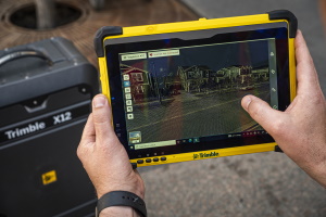
Trimble announced today a new high-performance data collector for its Mapping and Geographic Information Systems (GIS) portfolio—the Trimble TDC650 handheld. Built for GIS data collection, inspection and asset management activities, the TDC650 provides users a rugged solution with scalable high-accuracy Global Navigation SatelliteSystem (GNSS) positioning for professional field workflows. The TDC650 is fully integrated with ...
fieldtechnologiesonline.com