Geomaticians

Tree

Urban Tree Canopy Affects How Heat Stress Impacts Residents

Urban Tree Canopy Affects How Heat Stress Impacts Residents

One natural strategy to reduce heat-related deaths is to increase tree coverage in urban areas, which helps lower temperatures. A recent study highlights the disparities in health and energy consumption across the United States, stemming from insufficient urban tree coverage. It also details the potential health and economic advantages that increased tree presence can offer ...
geographyrealm.com
Prosegue La Mappatura Degli Alberi, Già Censite 3500 Piante 60 Dovranno Essere Abbattute

Prosegue La Mappatura Degli Alberi, Già Censite 3500 Piante: 60 Dovranno Essere Abbattute

Geat, società di gestione servizi per l’ambiente e il territorio, è stata incaricata dal Comune di Riccione di condurre un censimento completo del patrimonio arboreo presente sul territorio comunale. Il progetto, avviato nel 2023, ha l’obiettivo di valutare lo stato di salute e la sicurezza di circa 10.500 alberi, pari a un terzo del totale ...
riminitoday.it
Karte Des Monats Februar Infrarot-Luftbilder 2023

Karte Des Monats Februar: Infrarot-Luftbilder 2023

Zur Gewinnung von Luftbildern des Stadtgebiets wird Frankfurt jährlich beflogen. Dabei entstehen neben den herkömmlichen Luftbildern auch Infrarot-Aufnahmen. Spezielle Sensoren nehmen dabei den Infrarot-Kanal auf, der mit bloßen Augen nicht wahrgenommen werden kann. Dieser wird für die bessere Erkennbarkeit fototechnisch überarbeitet und in der Farbe Rot dargestellt. Als Ergebnis liefern die Infrarotluftbilder wertvolle Informationen über ...
frankfurt.de
Calgary Researchers Using High-Tech Drones To Map Alberta First Nation

Calgary Researchers Using High-Tech Drones To Map Alberta First Nation

Researchers and students at the Southern Alberta Institute of Technology are using sophisticated drones to digitally map Frog Lake First Nation. The nation, about 260 kilometres northeast of Edmonton, has relied on paper and low-resolution digital maps that no longer represent the community, according to the research team. “Maps are incredibly dynamic. They change quite ...
cbc.ca
New York Will Plant Thousands Of Trees Using New Tech To Maximize Foliage Impact

New York Will Plant Thousands Of Trees Using New Tech To Maximize Foliage Impact

New York City is poised to get a lot more trees. Last month, the city council passed a measure calling for 30% canopy cover by 2035, up from its current cover of 22% – which could mean 250,000 new trees. More trees, with all their cooling benefits, is a clear win for the environmental justice ...
theguardian.com
“Mancano Centinaia Di Alberi” I Cittadini Fotografano I Marciapiedi Spogli Del Nomentano

“Mancano Centinaia Di Alberi”: I Cittadini Fotografano I Marciapiedi Spogli Del Nomentano

Quanti sono gli alberi mancanti nelle strade di Roma? Non è semplice rispondere a questa domanda. A Roma manca un censimento aggiornato degli alberi e per farsi un’idea di quale sia l’effettiva carenza, si dovrebbero incrociare i dati dei tagli e delle nuove piantumazioni. Ma sono informazioni che saranno disponibili solo con il prossimo bilancio ...
romatoday.it

Younger Trees Champion Carbon Capture As Seen By ESA’s Biomass Earth Explorer Satellite

Thanks to their ability to absorb and store carbon dioxide from the atmosphere, forests have long been recognised as a key tool in the fight against climate change – but not all forests are equal. New research based on data from ESA’s SMOS satellite mission has found that, surprisingly, young trees are champions at carbon ...
spaceref.com

Study Shows Green Space-Bipolar Correlation

Settlements with more green spaces have a lower rate of bipolar disorder, a Taiwanese research team found. The researchers of the study shared the results yesterday at a press conference held by the Science Media Center Taiwan. The research team, using satellite remote sensing, machine learning and data analysis, found a significant negative association between ...
taipeitimes.com
Censo De Arbolado Público, Cuántos Hay Y Cómo Están

Censo De Arbolado Público, Cuántos Hay Y Cómo Están

El área metropolitana de Mendoza cuenta con más de medio millón de árboles censados y catalogados de acuerdo al lugar, especie y sustentabilidad. Con la presencia del sector público, académico y científico, autoridades de Ambiente y Unicipio, presentaron los datos preliminares y avanzados del Censo de Arbolado Público del Área Metropolitana y de la aplicación ...
cuyonoticias.com
New Tree Map Launched Following Planting Season

New Tree Map Launched Following Planting Season

A new online map showing trees planted in Haringey over the last year has been launched on the council’s groundbreaking tree web pages. The interactive map highlights the type and location of each new tree planted in the borough’s green spaces and streets in 2022/23. Its user-friendly design enables website visitors to zoom in to ...
haringey.gov.uk

Trees Are Not Always A Miracle Cure For Improving Air Quality

Donato Kofel has quantified the positive and negative effects of trees on outdoor air quality in Geneva Canton. His method can be used by city planners to design their large-scale planting programs more effectively. For his Master’s project at the end of his degree program, Kofel developed a new way to use the GIS application ...
phys.org
Beating The Heat Students Map California Tree Canopy To Cool Cities As Climate Warms

Beating The Heat: Students Map California Tree Canopy To Cool Cities As Climate Warms

This summer, a group of students are embarking on a groundbreaking project: mapping tree canopy cover in California. Tree canopies, which provide shade, can offset the heat island effect in cities. The effect is caused by buildings, roads and other human-made infrastructure absorbing and then re-emitting heat. In a warming climate, the heat island effect ...
calpoly.edu
We Wrocławiu Powstaje Mapa Koron Drzew. Czemu Ma Służyć

We Wrocławiu Powstaje Mapa Koron Drzew. Czemu Ma Służyć?

Wrocław jako drugie (po Warszawie) miasto w Polsce będzie korzystał z tworzonej właśnie mapy koron drzew, która powinna być gotowa jeszcze w tym roku. Mapa powstaje w ramach nowego, europejskiego projektu LIFECOOLCITY. Jak się ją przygotowuje i w jaki sposób przyczyni się do niwelowania zjawiska miejskich wysp ciepła? Realizacja projektu LIFECOOLCITY pomoże w określeniu „zielonych” ...
wroclaw.pl

Birmingham Creates Interactive Mapping Portal Using Bluesky Tree Data

Birmingham City Council has launched a first of its kind mapping portal to address the issue of tree equity across the city. With National Tree Map data, created by aerial mapping company Bluesky International, at its core, the interactive tool allows users to identify which parts of the city have lower than average tree canopy ...
directionsmag.com
Cartographier Les Arbres Géants Pour Mieux Les Protéger

Cartographier Les Arbres Géants Pour Mieux Les Protéger

Une nouvelle carte géographique publique, qui répertorie les grands arbres en Colombie-Britannique, vient d’être lancée en février 2023. L’organisme responsable du projet, la Raincoast Conservation Foundation, invite les citoyens à mesurer les arbres géants qui trônent autour d’eux. En les rendant visibles à tous, ils espèrent sensibiliser les populations à la protection des forêts. La ...
ici.radio-canada.ca
Une Carte Interactive Vous Invite À Découvrir 38000 Arbres Dans Renne

Une Carte Interactive Vous Invite À Découvrir 38000 Arbres Dans Rennes

Pour inciter les habitants à découvrir la richesse et la diversité de son patrimoine arboré, la Ville de Rennes propose une carte interactive affichant les caractéristiques (essence, âge…) de plus de 38000 arbres plantés le long des rues et dans les espaces verts. Cet outil a été développé par le Service d’information géographique (SIG) de ...
metropole.rennes.fr
Mumbai Activists Demand That The Tree Geo-tagging Information Be Made Public

Mumbai Activists Demand That The Tree Geo-tagging Information Be Made Public

Activists demand the information be made public to bring transparency to the process and increase citizen participation in tree conservation. In 2018, activist Gopal Jhaveri in Mumbai, discovered that four coconut trees in his area, Borivali, had been poisoned by miscreants to achieve a clear view for an advertisement hoarding. Jhaveri lodged a police complaint ...
india.mongabay.com
An Urban Oasis Online Map Identifies Native Trees On Marquette’s Campu

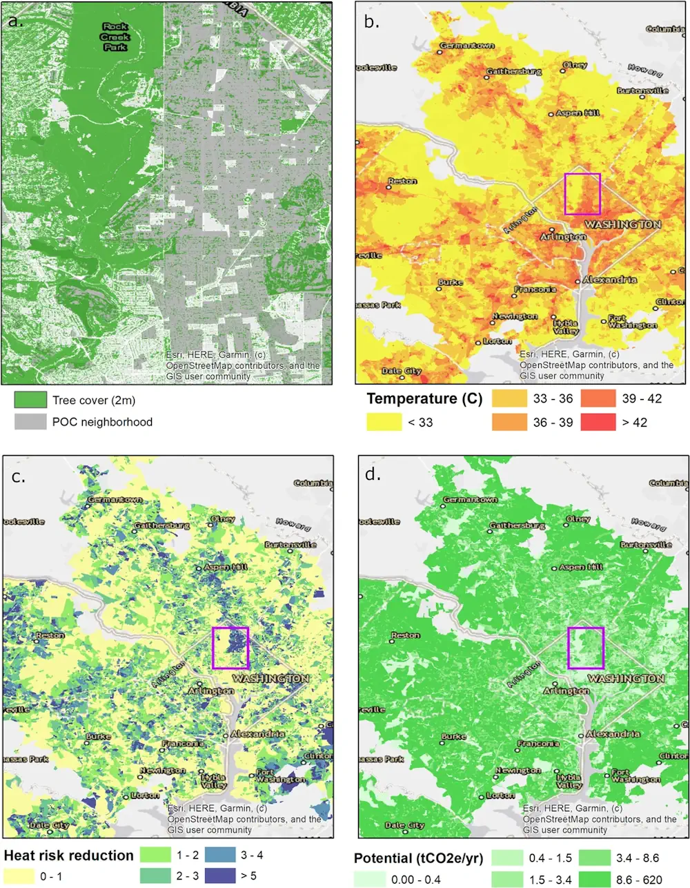
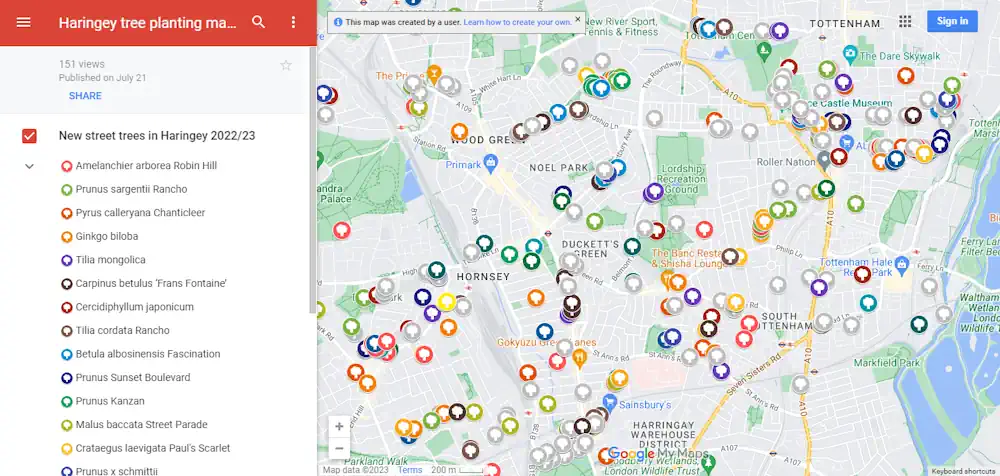
An Urban Oasis: Online Map Identifies Native Trees On Marquette’s Campus

Located in downtown Milwaukee, Wisconsin, Marquette University is an oasis of biodiversity. Most notably, Marquette’s high concentration of Wisconsin-native trees makes the campus a unique space for research, appreciating nature, discovering sacred spaces and more. In 2012, Facilities Planning and Management realized the opportunity Marquette’s campus offers the community and began taking inventory of Wisconsin-native ...
today.marquette.edu
Esta Plataforma Diz-lhe Tudo O Que Precisa De Saber Sobre As Árvores Do Porto

Esta Plataforma Diz-lhe Tudo O Que Precisa De Saber Sobre As Árvores Do Porto

Há uma plataforma onde pode ficar a saber tudo sobre as mais de 65 mil árvores públicas do Porto. Não só a parte científica mas também o seu estado de saúde, por exemplo. É no Portal de Informação Geográfica do Porto que vai encontrar essas informações, que são constantemente atualizadas.
newinporto.nit.pt
Risk Of Urban Tree Falls In São Paulo Is Influenced By Building Height And Neighborhood Age, Study Shows

Risk Of Urban Tree Falls In São Paulo Is Influenced By Building Height And Neighborhood Age, Study Shows

According to a study in the journal Urban Forestry & Urban Greening, the factors that most influence and increase the risk of tree failure in São Paulo (the capital of São Paulo state in Brazil) are the height of nearby buildings and the age of the neighborhood. Sidewalk width and tree height are the next ...
phys.org
Moradores Poderão Usar O Celular Para Cadastrar As Árvores Da Serra

Moradores Poderão Usar O Celular Para Cadastrar As Árvores Da Serra

A população da Serra vai ajudar a prefeitura a catalogar as árvores localizadas na zona urbana do município. Por meio do celular, cidadãos em geral poderão fotografar, identificar e registrar a localização das árvores, colaborando para a criação do banco de informações que vai servir de base para o Plano Diretor de Arborização Urbana do ...
eshoje.com.br