Geomaticians

Soil

Study Reveals Stable Soil Moisture Variability Within Fields, Opens Door For Satellite Remote Sensing

Study Reveals Stable Soil Moisture Variability Within Fields, Opens Door For Satellite Remote Sensing

A multi-institutional study led by University of Illinois and Agroecosystem Sustainability Center (ASC) scientists concluded that, although soil moisture varies significantly both within a single field and from field to field due to varying soil properties and different management practices, soil moisture distribution relative to the field average remains consistent across time within each field. ...
phys.org

Saudi Arabia Completes First Phase Of Desertification Assessment

The National Center for Vegetation Development and Combating Desertification (NCVC) has completed a significant step in its fight against desertification: the first phase of a project to assess the state of land degradation across the Kingdom, which resulted in the creation of 246 detailed maps. These maps provide valuable insight into desertification trends and the ...
gdnonline.com
Cranfield Researches Radar Drones For Soil Moisture Monitoring

Cranfield Researches Radar Drones For Soil Moisture Monitoring

Experts at Cranfield University are leading a two-year project which combines Synthetic Aperture Radar with uncrewed aerial vehicles (UAV), evaluating how radar-equipped drones could simplify soil moisture measurements and revolutionise flood and drought management. The project, led by Dr Dan Evans, will assess the accuracy and potential applications of the innovative technology in soil moisture ...
adsadvance.co.uk
Soil Atlas Depicts The Distribution Of Chemical Elements In Swiss Soils

Soil Atlas Depicts The Distribution Of Chemical Elements In Swiss Soils

Agroscope and the Federal Office for the Environment have published the first Geochemical Soil Atlas of Switzerland. It provides an overview of the large-scale distribution of 20 naturally occurring chemical elements in Swiss soils. The soil atlas will help the cantonal environmental protection agencies assess soil pollution levels and take action where necessary. The Geochemical ...
admin.ch

Dry Farm Researchers’ New Mapping Project Will Give Oregon Growers A Resource

As growing seasons become hotter and drier across the region, farmers are increasingly challenged to grow and sustain their crops. Now Oregon State University is close to launching a dry farming map project. Lucas Nebert, a research associate at OSU, heads the project. He told KLCC that a lot of farmers are interested in alternatives ...
opb.org
Experta Tecnología AGD Presenta En AAPRESID Su Nueva Plataforma Digital

Experta “Tecnología AGD” Presenta En AAPRESID Su Nueva Plataforma Digital

La importancia de la gestión del conocimiento en las empresas agropecuarias cada vez tiene más relevancia al momento de tomar decisiones. La evolución de la agricultura en los últimos años, el aumento de la información y las nuevas tecnologías generan una oportunidad para hacer más eficiente la producción agropecuaria, pero sistematizar y ordenar todos los ...
agritotal.com
'Underground Climate Change' Threatens To Destabilize Buildings

‘Underground Climate Change’ Threatens To Destabilize Buildings

The earth beneath our major cities is heating up, morphing in ways that could damage buildings, bridges, and transport systems. Just ask any passenger sweltering on the London Underground or New York City subway, and they’ll perspire telling you about how underground transport systems are spewing heat. As that heat diffuses into the ground, it’s ...
sciencealert.com
New Remote Sensing Method Helps Monitor The Results Of Peatlands Rehabilitation

New Remote Sensing Method Helps Monitor The Results Of Peatlands Rehabilitation

Peatlands constitute one of the most important carbon stores on the planet. Rehabilitation aims at restoring drained peatlands to their natural state. Earth’s peatlands store nearly one-third of all carbon sequestered into soil. When peatlands are drained – or dried – the carbon stored within is released into the atmosphere. A total of 50 million ...
aalto.fi

Digitale Karte Dokumentiert Saure Waldböden

Die Zürcher Wälder sind wie viele andere Gebiete in Mitteleuropa von Bodenversauerung betroffen. Das Amt für Landschaft und Natur hat rund zehn Prozent der Waldböden im Kanton genauer untersucht und die Ergebnisse in einer digitalen Karte dokumentiert. Für die Bewirtschaftung dieser Wälder, gerade angesichts des Klimawandels, wird die Waldbodenkarte wertvolle Zusatzinformationen geben.
zh.ch

Aggiornamento Atlante Delle Analisi Del Terreno

E’ online sul Geoportale l’aggiornamento del servizio regionale “Atlante delle analisi del terreno”. L’Atlante è un servizio di consultazione e diffusione online dei dati di analisi dei terreni dove si possono trovare informazioni “puntuali” sullo strato superficiale dei terreni agrari del Piemonte. L’aggiornamento è consistito nell’ampliamento del numero di analisi disponibili grazie alla georeferenziazione di ...
regione.piemonte.it

Gugik Publikuje Model Pojęciowy Oraz Schemat Aplikacyjny Dla Mapy Glebowo-rolniczej

Główny Urząd Geodezji i Kartografii we współpracy z Instytutem Upraw Nawożenia i Gleboznawstwa – PIB oraz w uzgodnieniu z Ministerstwem Rolnictwa i Rozwoju Wsi opracował model pojęciowy bazy danych oraz schemat aplikacyjny GML dla mapy glebowo-rolniczej dla skali 1:5000 w postaci wektorowej. Większość dostępnych dzisiaj w PZGiK map glebowo-rolniczych w skali 1:5 000 opracowano od ...

Les Sols Des Zones Oasiennes En Proie À Une Baisse De Fertilité

La dégradation des sols des palmeraies impacte négativement la fertilité de cet écosystème aussi rare qu’essentiel sur le plan social. Grâce à une étude réalisée par des scientifiques marocains, la caractérisation des besoins des terres oasiennes via des cartes thématiques permettra de se prémunir contre ce danger. L’étude en question a été déclinée sous forme ...
medias24.com
Geographic Technology Provides Landowners With Precise Tools When Making Land Management Decisions

Geographic Technology Provides Landowners With Precise Tools When Making Land Management Decisions

According to Lee Burras and Bradley Miller, agronomists at Iowa State University, advances in geospatial technology coupled with more traditional farming knowledge have allowed researchers and landowners to understand the land more intimately than ever before. Miller, who began his career working in water quality, has seen firsthand how soil can be impacted by the ...
extension.iastate.edu
Córdoba Actualizó Los Mapas Digitales De Propiedades De Suelo

Córdoba Actualizó Los Mapas Digitales De Propiedades De Suelo

A través de un trabajo interinstitucional, la provincia de Córdoba actualizó los mapas digitales, a escala semi-predial, de materia orgánica (MO), fósforo (P) y Ph. Estas actividades forman parte de la estrategia de Mapeo Digital de Suelos (MDS), en una labor colaborativa iniciada hace más de 3 años entre el Ministerio de Agricultura y Ganadería, ...
agroverdad.com.ar

State Unveils Interactive Soil, Water Sampling Map

The Pennsylvania Department of Environmental Protection (DEP) on Tuesday released a new interactive mapping tool that shows final sample results from soil and water testing conducted by DEP in the wake of the Feb. 3 East Palestine train derailment. Pennsylvanians can use this tool to review sampling results in the vicinity of the derailment. The ...
latrobebulletinnews.com
Con Datos Geoespaciales Cuantifican El Estado De Los Suelos Degradados En Chile

Con Datos Geoespaciales Cuantifican El Estado De Los Suelos Degradados En Chile

El Ministerio de Agricultura impulsó en 2010 el ‘Sistema de Incentivos para la Recuperación de Suelos Degradados (SIRSD-S)’, un instrumento que busca rescatar el potencial productivo de los suelos agropecuarios en degradación. La iniciativa es coordinada por la Subsecretaría de Agricultura y ejecutada por el Servicio Agrícola y Ganadero (SAG), en conjunto con el Instituto ...
mundoagro.cl

Pesquisador Da USP Desenvolve Método Para Calcular Potencial Produtivo Dos Solos

O Engenheiro agrônomo, Lucas Tadeu Greschuk, conversou com o Brasil Rural para explicar o método desenvolvido na Universidade de São Paulo (USP) para calcular o potencial produtivo dos solos agrícolas. O método surgiu durante as pesquisas de Greschuk no mestrado em solos e nutrição de plantas com ênfase em “sensoriamento remoto” pela Escola Superior de ...
radios.ebc.com.br
BVI Launches Comprehensive Soil Study

BVI Launches Comprehensive Soil Study

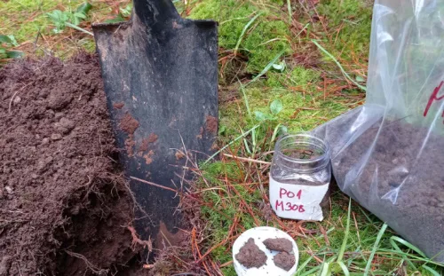
The Department of Disaster Management (DDM) will be carrying out a study of soils throughout the Territory as part of a Darwin Plus-funded research project launched this week. The study will be conducted in partnership with other government agencies, the H. Lavity Stoutt Community College, and the University of Portsmouth (United Kingdom). The study will ...
bvi.gov.vg

Syngenta Interra Scan Soil Mapping Service Allows Growers To Better Understand Soil Health

Syngenta has unveiled its high-resolution soil mapping service, Interra Scan, at the agricultural innovation event Fields of Innovation 2022. The Interra Scan service, which offers precision soil analysis to help growers and agronomists optimise crop nutrition and soil health, will be initially available to continental and Eastern European growers. Interra Scan offers high-resolution soil mapping ...
futurefarming.com

Pilotprojekt Nationaler Bodenkartierung Startet In Lommis

Der Bund plant eine landesweite und einheitliche Bodenkartierung. Dafür wird derzeit vom Kompetenzzentrum Boden (Kobo) an der Berner Fachhochschule (BFH-HAFL) in Zollikofen eine neue Methodik entwickelt. Mit technischen Innovationen sowie dem Einsatz von Satellitentechnologie und Computermodellierung soll die Kartierung grösserer Gebiete zeit- und kostengünstiger werden als bisher. Vorhandene Bodeninformationen werden dabei verwendet. Ziel ist es, ...
nau.ch

Satelita Z Gliwic Pomoże Rolnikom W Doborze Nawozów

W kwietniu przyszłego roku na orbitę wyniesiony zostanie stworzony w Gliwicach satelita rolniczy Intuition-1, którego zdaniem będzie m.in. określanie zawartych w glebie makroelementów. Pomoże to rolnikom m.in. w doborze odpowiednich nawozów – tłumaczą twórcy urządzenia z firmy KP Labs. Intuition-1 to satelita z instrumentem hiperspektralnym, czyli instrumentem optycznym służącym do obserwacji Ziemi. – Jego zadaniem ...
farmer.pl

Varsity Prepares GIS-based Soil Map Of Ahmedabad City

CEPT university has prepared a Global Positioning System and Geographical Information System (GIS)-based soil map of Ahmedabad city in hopes of paving a solution for repeated cave-ins and flooding in Ahmedabad city. The map was prepared by the university’s Faculty of Technology last year, using geospatial technology. Information was collected from 563 points across the ...
indianexpress.com

An Der TU Dresden Entwickelte Bodenfeuchteampel Zeigt, Wie Trocken Sachsens Wälder Sind

Die sächsischen Wälder sind zu trocken. Wie dramatisch die Situation ist, zeigt auch die von Dr. Rico Kronenberg von der Professur für Meteorologie an der TU Dresden entwickelte Bodenfeuchteampel. Mithilfe dieses online verfügbaren Tools können auch Laien schnell nachvollziehen, wie es um die Bodenfeuchte in den Wäldern Sachsens steht. Die eigentliche Zielgruppe sind jedoch die ...
idw-online.de