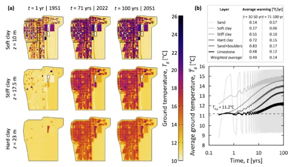
Geomaticians

Simulation

AI Shows How Field Crops Develop

AI Shows How Field Crops Develop

Researchers at the University of Bonn have developed software that can simulate the growth of field crops. To do this, they fed thousands of photos from field experiments into a learning algorithm. This enabled the algorithm to learn how to visualize the future development of cultivated plants based on a single initial image. Using the ...
eurekalert.org

Orman Yangınlarının Önüne LİDAR Teknolojisiyle Geçilecek

Karadeniz Teknik Üniversitesi Öğretim Üyesi Doç. Dr. Alperen Coşkuner, orman yangınlarını, LİDAR olarak bilinen lazer tarama teknolojisi ile belirlenebileceğini, bu alanda yaptıkları ilk araştırmaların yüksek doğrulukta sonuçlar verdiğini bildirdi. Orman yangınlarıyla mücadelede başarılı olabilmek, yangın risk ve tehlike potansiyeli ile yangın davranışı hakkında doğru ve hızlı bilgi verebilen kapsamlı sistemlerin varlığıyla mümkün olabilirken bu sistemlerin ...
aa.com.tr
StarNav Receiver Produces Positioning And Timing Results Using Simulated Xona PULSAR Signals

StarNav Receiver Produces Positioning And Timing Results Using Simulated Xona PULSAR Signals

In a recent demonstration, a StarNav receiver yielded 20 cm positioning precision from a cold start using simulated Xona PULSAR signals. StarNav’s receiver tracked up to 13 signals from Xona PULSAR satellites, StarNav CEO Joshua Morales said. The signals were simulated by a Safran simulator. Morales showcased the results at ION GNSS+ in Denver earlier ...
insidegnss.com
Images Of Simulated Cities Help Artificial Intelligence To Understand Real Streetscapes

Images Of Simulated Cities Help Artificial Intelligence To Understand Real Streetscapes

Recent advances in artificial intelligence and deep learning have revolutionized many industries, and might soon help recreate your neighborhood as well. Given images of a landscape, the analysis of deep-learning models can help urban landscapers visualize plans for redevelopment, thereby improving scenery or preventing costly mistakes. To accomplish this, however, models must be able to ...
techxplore.com
Modelo Geoespacial Analisa A Relação Custo-benefício Dos Telhados Verdes Nas Cidades

Modelo Geoespacial Analisa A Relação Custo-benefício Dos Telhados Verdes Nas Cidades

Telhados verdes têm sido apontados como uma das possíveis soluções para o combate às mudanças climáticas nas cidades. Isso porque, além de permitirem a captação de água da chuva e a produção de hortaliças no alto dos edifícios, eles também são capazes de gerar microclima, reduzindo a temperatura local e o gasto energético com refrigeração, ...
mundogeo.com
How Digital Twins Can Help Turning An Urban Oven Into An Oasis

How Digital Twins Can Help Turning An Urban Oven Into An Oasis

It’s all over the news: Urban areas tend to become extremely hot these days. To properly cool down our cities, “we need digital twins in the early stages of city planning”, says Stefan Trometer, Managing Director at Virtual City Systems. To Southern Europe for a city trip in the summer is becoming increasingly challenging. As ...
innovationorigins.com
'Underground Climate Change' Threatens To Destabilize Buildings

‘Underground Climate Change’ Threatens To Destabilize Buildings

The earth beneath our major cities is heating up, morphing in ways that could damage buildings, bridges, and transport systems. Just ask any passenger sweltering on the London Underground or New York City subway, and they’ll perspire telling you about how underground transport systems are spewing heat. As that heat diffuses into the ground, it’s ...
sciencealert.com

Terrabyte: Germany’s New High Performance Data Analytics Platform For Earth Observation

A new high performance data analytics platform called terrabyte has been announced that will enable researchers in Bavaria and Germany to use satellite and earth observation data for classical simulations and evaluation using artificial intelligence methods. The new system is jointly run by the German Aerospace Center (DLR), a national research center for aeronautics and ...
datanami.com

NASA Supercomputer Enables Seasonal Forecasts for High Mountain Asia

Using forecasts run on a NASA supercomputer, scientists from Oak Ridge National Laboratory (ORNL); NASA Goddard Space Flight Center; the University of California, Berkeley; and the Korea National University of Transportation assessed the ability of NASA’s Goddard Earth Observing System Subseasonal to Seasonal Version 2 (GEOS-S2S-2) forecasting system to predict atmospheric and land surface conditions ...
nccs.nasa.gov

Altair Releases SimSolid Cloud Simulation Software

Late last month, simulation and artificial intelligence specialist Altair announced the release of their latest software offering, Altair SimSolid Cloud. The cloud-native simulation software offers convenience, with the ability to be used on any web browser from any device, and improved efficiency. To that latter point, Altair says “SimSolid Cloud eliminates geometry simplification and meshing, ...
geoweeknews.com
SwRi Tests Automated Vehicles In Virtual Off-road Environments

SwRi Tests Automated Vehicles In Virtual Off-road Environments

Southwest Research Institute (SwRI) has created a 3D simulation tool to test automated vehicles in virtual off-road environments modeled after real-world conditions. The research expands SwRI’s investment into software-in-the-loop solutions to test connected and automated vehicles (CAVs) in scenarios ranging from congested roadways to off-road terrain. SwRI’s simulator consists of a graphics engine, dynamics engine, ...
eurekalert.org
Invasive Plant Species Will Spread Even Further In Germany According To Simulation Study

Invasive Plant Species Will Spread Even Further In Germany According To Simulation Study

Many invasive plant species have not yet filled their potentially suitable habitat. This is what geographers at Leipzig University established in a recent simulation study. They coupled different data sets to predict the probability of occurrence of selected invasive plant species for any location in Germany. “Using satellite imagery to divide Germany into quadrants, I ...
phys.org
Maxar Unveils 3D Digital Twin For VR And Simulation

Maxar Unveils 3D Digital Twin For VR And Simulation

Maxar Technologies and blackshark.ai have collaborated to develop SYNTH3D, a synthetic 3D digital twin of the Earth’s surface that is highly compatible and visually pleasing for use in gaming, simulation, entertainment, virtual reality (VR), smart city, and metaverse applications. This high-performance 3D model, created using blackshark.ai’s patented generative artificial intelligence (AI) technology and Maxar’s Vivid ...
gim-international.com

بلدية دبي تدشن «محاكاة تخطيط المدينة» لتوفير 40% من الوقت والجهد

كشفت المهندسة ميثاء النعيمي، مدير إدارة مركز نظم المعلومات الجغرافية في بلدية دبي، عن أن مشروع «محاكاة سيناريوهات تخطيط المدينة» في البيئة الإفتراضية، الذي دشنته البلدية ضمن فعاليات «جيتكس 2022» في يومه الأول، من شأنه تقليل الوقت والجهد بنسبة تصل إلى 40%، خاصة أن تخطيط المشاريع كان يجري بواسطة برامج تخصصية يتطلب وقتاً عالياً، إضافة ...
alkhaleej.ae
Szkoła Letnia W Stuttgarcie Z Udziałem Polskich Studentów

Szkoła Letnia W Stuttgarcie Z Udziałem Polskich Studentów

19 studentów Uniwersytetu Przyrodniczego we Wrocławiu wzięło udział w Szkole Letniej „Simulation in the City” zorganizowanej w dniach 14-19 września 2022 r. w Stuttgarcie w Niemczech przez tamtejszy Uniwersytet Techniczny (HFT Stuttgart). Reprezentowali oni pierwszy rok studiów magisterskich na kierunku geodezja i kartografia w dwóch specjalnościach: geoinformatyka i geodezja inżynieryjna.
geoforum.pl
Mapas Inteligentes Para Poner Freno A Los Incendios Un Simulador 3D De Gran Canaria Ayudará A Gestionar Fuegos En Europa

Mapas Inteligentes Para Poner Freno A Los Incendios: Un Simulador 3D De Gran Canaria Ayudará A Gestionar Fuegos En Europa

El Cabildo de Gran Canaria ha implantado un simulador 3D de incendios forestales por escáner pionero que utiliza sistemas de información geográfica (GIS) para analizar datos en tiempo real con los que prever cómo se va a comportar el fuego, a qué zonas alcanzará, cómo se moverá y en qué momento ocurrirá para actuar en ...
eldiario.es
Microsoft Announces Simulator For Autonomous Aircraft Development

Microsoft Announces Simulator For Autonomous Aircraft Development

Microsoft has unveiled a simulator for training autonomous drones, powered by Microsoft Azure to allow for millions of complex flight simulations per second. Project AirSim is the successor to Microsoft’s earlier AirSim, beginning its life as a research project based in Unreal, but requiring an extensive understanding of machine learning and coding. The newly-announced iteration ...
itpro.co.uk