Geomaticians

Sentinel-2

Esri Releases Latest Land Cover Map With Updated Sentinel-2 Satellite Data

Esri, the global leader in location intelligence, in its partnership with Impact Observatory, has released an updated global land-use/land-cover map of the world based on the most up-to-date 10-meter Sentinel-2 satellite data. In the update, the Sentinel-2 10m Land Use/Land Cover Time Series includes new data from 2023, expanding the series to include global coverage ...
businesswire.com
Estimating Coastal Water Depth From Space Via Satellite-Derived Bathymetry

Estimating Coastal Water Depth From Space Via Satellite-Derived Bathymetry

With the development of shipborne echo sounders in the early 20th century, bathymetric surveys saw massive leaps in both accuracy and convenience. However, even with modern echo sounders, there are still many hardships to overcome when conducting bathymetric surveys. These include high cost, unpredictable weather, high ship traffic, and potential geographic or diplomatic issues, to ...
eurekalert.org
Satellites And AI Could Help Farmers Detect Soybean Aphid Infestations

Satellites And AI Could Help Farmers Detect Soybean Aphid Infestations

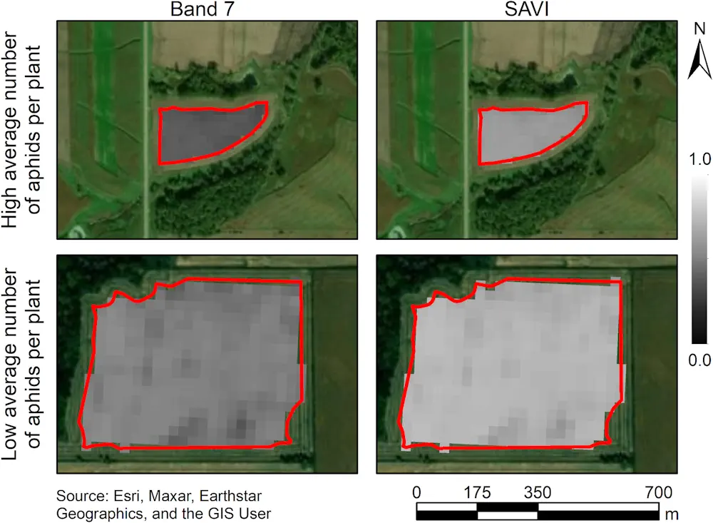
Satellite-based remote sensing allows us to see much more than we can see when standing on the ground. New research from the University of Minnesota found, when combined with artificial intelligence, remote sensing could dramatically improve management of soybean aphid, an invasive pest that negatively impacts soybean yield and quality. Published in the journal Crop ...
twin-cities.umn.edu
Imágenes Satelitales Ópticas Y De Radar, Claves Para El Monitoreo De Cultivos De Papa

Imágenes Satelitales Ópticas Y De Radar, Claves Para El Monitoreo De Cultivos De Papa

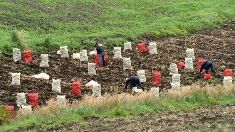
La producción de papa, uno de los tubérculos más importantes para la canasta básica diaria familiar de los colombianos, además de presentar desafíos como el incremento de los costos de transporte e insumos para su cultivo que afectan el bolsillo de los productores, es constantemente vulnerable a que la sobreoferta, producto muchas veces de la ...
agronegocios.co
In 2020, 30% Of The Pantanal Was Burned To Cinders By Wildfires

In 2020, 30% Of The Pantanal Was Burned To Cinders By Wildfires

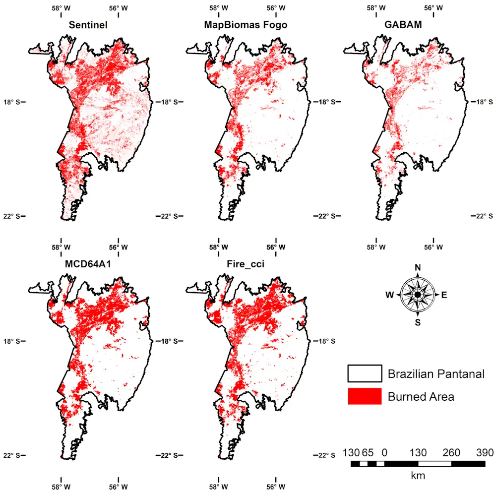
In 2020, the Pantanal, the largest tropical freshwater wetland in the world and a biodiversity hotspot, was swept by high-intensity fires that destroyed native vegetation in an area totaling 44,998 square kilometers (km²), or about 30% of the Brazilian portion of the biome, which spans some 150,000 km². The estimate is presented in an article ...
eurekalert.org
Measuring Nutrition In Crops From Space

Measuring Nutrition In Crops From Space

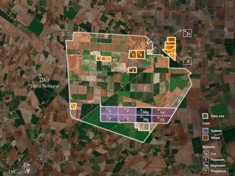
With many people around the world suffering from various forms of malnutrition it’s important that the absolute basics such as rice, soya and wheat are as nourishing as possible. ESA-funded research shows that the Copernicus Sentinel-2 mission and the Italian Prisma mission could be used to monitor the nutritional content of staple crops. This could, ...
esa.int
IA Torna Mais Preciso O Mapeamento Da Intensificação Agrícola No Cerrado

IA Torna Mais Preciso O Mapeamento Da Intensificação Agrícola No Cerrado

Metodologia pioneira, desenvolvida com suporte da Inteligência Artificial (IA), permitiu o alcance de um nível de acurácia de até 97%, quando aplicada em análises de imagens de satélite do Cerrado do município de Sorriso (MT), um dos principais produtores agrícolas do País. A acurácia é um aspecto relevante nos levantamentos realizados por meio de sensoriamento ...
mundogeo.com
AI2 Researchers Introduce Satlas A New AI Platform For Exploring Global Geospatial Data Generated By Artificial Intelligence From Satellite Imagery

AI2 Researchers Introduce Satlas: A New AI Platform For Exploring Global Geospatial Data Generated By Artificial Intelligence From Satellite Imagery

Manual curation of geospatial data, especially in the realm of renewable energy infrastructure and natural resource monitoring, involves a thorough process of aggregating, cleaning, and correcting datasets from various sources, often across multiple countries. This challenge has hindered efforts in emissions reduction, disaster relief, urban planning, and more, where precise geospatial insights are paramount. While ...
marktechpost.com

Civil Engineers Use Public Satellite Images To Study Why The Jagersfontein Dam Failed

On 11 September 2022, a diamond mine waste storage facility, known as a tailings dam, failed in the town of Jagersfontein in the Free State province of South Africa. In the failure, one person was killed and multiple homes destroyed. Tailings are the finely ground leftovers that remain after valuable metals are removed from rock ...
sciencedaily.com

Esri Releases New App To Easily View And Analyze Global Land-Cover Changes

Esri, the global leader in mapping and location intelligence, has now released a new online application, Sentinel-2 Land Cover Explorer. The app is structured around a web-based version of its own high-resolution global land-cover map, derived from European Space Agency (ESA) Sentinel-2 satellite imagery. The app is easy to access and leverages the same geographic ...
geospatialworld.net
El CDR Crea El Primer Mapa De Cultivos Abandonados Con El Uso De Imágenes De Satélite

El CDR Crea El Primer Mapa De Cultivos Abandonados Con El Uso De Imágenes De Satélite

Quantify the abandonment of agricultural land using images from the Sentinel-2 satellite. This is the latest study completed by the Centre de Desenvolupament Rural de la Safor and will be presented in the coming weeks. A research included in the Copernicus program of the European Commission and that has allowed to evaluate the figures and ...
cadenaser.com

Using Sentinel-2 Data For Seawater Quality Monitoring

In an article published in the journal Remote Sensing, the researchers used Sentinel-2/Multispectral Instrument (MSI) imagery data to a calibrated ocean chlorophyll 2-band (OC-2) model to retrieve chlorophyll-a (chl-a) concentration in the Ha Long bay from 2019 to 2021. Using Sentinel-2 MSI photos on the Google Earth Engine (GEE) platform, this study examines the anthropogenic ...
azooptics.com

Dall’elaborazione Statistica Di Immagini Sentinel-2 Al Monitoraggio Quantitativo Della Siccità: Primi Risultati Di ISPRA

Nell’ambito della Convenzione Operativa ASI-ISPRA “Habitat Mapping” (2017-2021), l’Area Idrologia, Idrodinamica e Idromorfologia di ISPRA, in collaborazione con il Politecnico di Milano, ha sviluppato e implementato degli algoritmi e delle procedure per la mappatura e la classificazione degli alvei fluviali nelle tre componenti costitutive – superficie bagnata, vegetazione, sedimenti – a partire dalle immagini di ...
isprambiente.gov.it