Geomaticians

Photogrammetry

Leica Geosystems Announces New Leica DMC-4 Airborne Imaging Sensor Delivering Superior Image Fidelity

Leica Geosystems, part of Hexagon, today announced the introduction of the Leica DMC-4, a highly efficient airborne imaging sensor providing unsurpassed image quality for various applications and complex mapping environments. The new system continues Leica Geosystems’ tradition of combining industry-leading optics with precision mechanics to deliver the highest mapping performance. The sensor provides superior image ...
directionsmag.com

Hexagon Announces Aerial Data Collection Of Eight US States

Hexagon’s Geosystems division announced today that the HxGN Content Program will refresh data for eight U.S. states during this year’s collection season. All states — California, New York, Pennsylvania, Oregon, Kentucky, Michigan, North Carolina, and West Virginia — will be updated at a 6-inch (15-centimeter) resolution statewide, marking the program’s shift from a 12-inch to ...
geospatialworld.net
Quando I Rifiuti Raccolti Sulla Spiaggia Diventano Pezzi Da Museo

Quando I Rifiuti Raccolti Sulla Spiaggia Diventano Pezzi Da Museo

In mezzo a luoghi incantevoli come l’arenile di Pantanagianni, è nato in Puglia, nel 2018, Archeoplastica, un progetto di sensibilizzazione sull’inquinamento del mare i cui protagonisti sono volontari che raccolgono i rifiuti presenti sulle spiagge di questi territori. Tutto è cominciato grazie a Enzo Suma – guida naturalistica e «cercatore di ulivi secolari e antichi ...
linkiesta.it

Mapping US Coastlines May ‘Drive More Equality’ In Climate Adaptation Policy

A Canadian technology company is using aerial imagery to build high-precision maps of US shorelines that will be used to help coastal communities adapt to climate change. By cataloguing which neighborhoods have more impervious surfaces like sidewalks and driveways compared to permeable ground with vegetation and trees, policymakers can better predict where heat waves or ...
financialpost.com

Fotografía Aérea En Extremadura: Podrás Ver Tu Casa Con Detalle

Extremadura obtendrá imágenes aéreas de la región, con resolución de 25 cm a tamaño de píxel. Así lo ha publicado la consejería de Agricultura, Desarrollo Rural, Población y Territorio ha publicado en el Diario Oficial de Extremadura (DOE). Se trata de un convenio suscrito entre el Centro Nacional de Información Geográfica (CNIG), organismo autónomo adscrito ...
elperiodicoextremadura.com
Ukrainians Using New Smartphone App To Make Precious 3D Records Of War-threatened Historic Buildings And Monuments

Ukrainians Using New Smartphone App To Make Precious 3D Records Of War-threatened Historic Buildings And Monuments

A new smartphone app is offering hope to people trying to preserve Ukraine’s war-threatened historic buildings. The “Backup Ukraine” project now lets ordinary people become archivists by using an app to digitally capture buildings and monuments as 3D models. Already, the app has recorded more than 6,000 downloads, and has between 30 and 50 active ...
abc.net.au

Ψηφιακή Χαρτογράφηση Του Σπηλαίου Κιλκίς

Το Σπήλαιο του Λόφου Αγίου Γεωργίου, το υπόγειο κόσμημα της πόλης του Κιλκίς, με εντυπωσιακό όσο και σπάνιο κοραλλιογενές διάκοσμο, με άφθονους σταλακτίτες και σταλαγμίτες, ‘’αναδύεται’’ από τα έγκατα της γης, χάρη στις νέες ψηφιακές τεχνολογίες που ανοίγουν το δρόμο για την εικονική περιήγησή του. Το Σπήλαιο Κιλκίς θα χαρτογραφηθεί ψηφιακά από ερευνήτρια του ΔΙΠΑΕ, ...
kede.gr
The Routledge Handbook of Mapping and Cartography

The Routledge Handbook of Mapping and Cartography

This new Handbook unites cartographic theory and praxis with the principles of cartographic design and their application. It offers a critical appraisal of the current state of the art, science, and technology of map-making in a convenient and well-illustrated guide that will appeal to an international and multi-disciplinary audience. No single-volume work in the field ...
routledge.com

광주시, 2022년 촬영 고해상도 항공사진 서비스 실시

광주시는 고해상도 디지털 항공사진 구축을 완료하고 공간정보시스템(GIS) 및 생활지리웹포털에 탑재해 본격적인 서비스에 들어갔다고 25일 밝혔다. 고해상도 항공사진은 도시개발, 도로개설, 각종 인허가 등으로 변화하는 지형정보의 지속적인 관리와 다양한 행정업무에 기초자료로 활용하기 위해 시 전역(431.05㎢)을 대상으로 구축을 완료했다. 항공사진은 2022년 4월에 촬영한 최신의 디지털 항공사진으로 광주시의 지형변화에 대한 시계열 관리는 물론, 인‧허가 불법행위 단속, 과세자료 정비, 주택가격 ...
vision21.kr

Sympozjum Fotogrametryczne Już Za Dwa Miesiące

Do 5 września wydłużony został termin rejestracji na XXII Ogólnopolskie Sympozjum Naukowe Polskiego Towarzystwa Fotogrametrii i Teledetekcji pt. „Fotogrametria – Teledetekcja – Geoinformacja: stan aktualny i tendencje rozwoju”. Wydarzenie odbędzie się w dniach 26–28 września 2022 r. w Krakowie, na Wydziale Geodezji Górniczej i Inżynierii Środowiska AGH.
geoforum.pl
Un Estudiante De La UCAM Introduce Al Museo Del Cristo De La Sangre En El Metaverso

Un Estudiante De La UCAM Introduce Al Museo Del Cristo De La Sangre En El Metaverso

El mundo de la cultura en general y de los museos en particular están explorando las infinitas posibilidades de expansión que les ofrecen las nuevas tecnologías. El desarrollo del metaverso, gracias al avance de los dispositivos y aplicaciones, ofrece experiencias que eran impensables hasta hace poco y que ya son una realidad. Una buena muestra ...
cope.es

Bornova’nın Dijital Haritası Çıkarıldı

Bornova Belediyesi, Bornova’nın bütün sokaklarının yüksek çözünürlüklü 360 derece panoramik görüntüsünü çıkardı. Bornova Belediyesi, 3 santimetre hassasiyetle ölçüm yapan sistem sayesinde imardan numarataja, tabela büyüklüklerinden ruhsata kadar pek çok alanda çok büyük bir hızla işlem yapacak.
kanalben.com
Microsoft Announces Simulator For Autonomous Aircraft Development

Microsoft Announces Simulator For Autonomous Aircraft Development

Microsoft has unveiled a simulator for training autonomous drones, powered by Microsoft Azure to allow for millions of complex flight simulations per second. Project AirSim is the successor to Microsoft’s earlier AirSim, beginning its life as a research project based in Unreal, but requiring an extensive understanding of machine learning and coding. The newly-announced iteration ...
itpro.co.uk
Erzurum 3D Veriyle Haritalandırılacak

Erzurum 3D Veriyle Haritalandırılacak

Erzurum Kalesi önünde, proje doğrultusunda “Dron ile Dijital Şehir İkiz Güncelleme Çalışması” toplantısı düzenlendi. Bakanlık, valilik ve Büyükşehir Belediyesinin işbirliğinde hazırlanan projede, 50 kişilik ekip, 25 dronla 56 farklı lokasyonda harita çalışması yapacak ve 202 yer kontrol noktası tespit edilerek gerekli ölçümler yapılacak. Yaklaşık 1,5 ay sürecek çalışma sonucu elde edilecek dijital verilerle Erzurum’un 3 ...
aa.com.tr

Reverse-engineering Insect Brains To Make Robots

British startup Opteran, a spin–out of the University of Sheffield, has a completely different view of neuromorphic engineering compared to most of the industry. The company has reverse–engineered insect brains to derive new algorithms for collision avoidance and navigation that can be used in robotics. Opteran calls its new approach to AI “natural intelligence,” taking ...
eetimes.com
Mapping A Volcanic Eruption In The Backyard Of Iceland’s Capital

Mapping A Volcanic Eruption In The Backyard Of Iceland’s Capital

On 19 March 2021, the volcano Fagradalsfjall began to erupt, suggesting that volcanoes on Iceland’s Reykjanes Peninsula had awakened from an 800-year slumber. Although most volcanism in Iceland occurs in regions far from population centers, eruptions on the Reykjanes Peninsula can threaten residents. Pedersen and a team of scientists came together to create maps to ...
eos.org
Aboriginal Teen Uses Drone Technology To Preserve Heritage

Aboriginal Teen Uses Drone Technology To Preserve Heritage

An Aboriginal teenager from Far North Queensland is using the power of drone technology to preserve the history of the Wallara clan of the Koko-Muluridji people. 19-year-old James Cook University Bachelor of Science student, Gullara McInnes has combined her love of drones and mapping with her passion for her traditional country to give local Elders ...
theeducatoronline.com
Nebraska State Patrol To Use Mapping Drones In Crash Investigations

Nebraska State Patrol To Use Mapping Drones In Crash Investigations

The Nebraska State Patrol said Thursday that it has found a way to reduce crash response times by expanding its drone-mapping program. Gov. Pete Ricketts and NSP Capt. John Bolduc said during a presentation Thursday morning that the goal of the program is to mitigate road closures while on the scene of a crash. The ...
1011now.com

Tehran To Host Intl. Geospatial Conference

The event is organized by the School of Surveying and GeoSpatial Engineering, College of Engineering, University of Tehran. This will be the 6th SMPR (Sensors and Models in Photogrammetry and Remote Sensing) and the 4th GIResearch (Geospatial Information Research) conferences which will be co-organized with the support of the International Society of Photogrammetry and Remote ...
tehrantimes.com
App Generiert Aktuelle Digitale Straßenkarten Für Die Stadt

App Generiert Aktuelle Digitale Straßenkarten Für Die Stadt

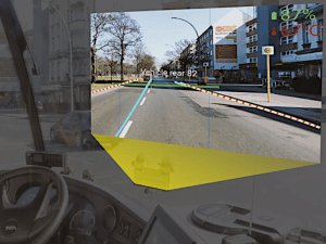
Um möglichst aktuelle digitale Straßenkarten einer Stadt erstellen zu können, die temporäre Pop-up-Radwege, neue Baustellen, veränderte Spurführungen, nicht lesbare Verkehrsschilder und Ähnliches beinhalten, hat das Fraunhofer-Institut für offene Kommunikationssysteme (Fokus) eine Smartphone-App entwickelt. Diese werden mit deaktiviertem Bildschirm an der Windschutzscheibe von Fahrzeugen befestigt, die sowieso regelmäßig durch die Stadt fahren, etwa von Bussen oder ...
springerprofessional.de

Tecnología En 3D Para La Conservación Del Patrimonio De Marchena

El Ayuntamiento de Marchena, desde la Delegación de Turismo, ha comenzado los primeros trabajos de escaneado 3D de la Iglesia de San Juan. Un nuevo proyecto que tiene como finalidad la conservación de este bien de interés cultural de gran importancia en Marchena. Esta técnica 3D permitirá apreciar detalles de la iglesia que a simple ...
aionsur.com