Geomaticians

NOAA

NOAA Seeks Applications For 2024 Urban Heat Island Initiative

NOAA Seeks Applications For 2024 Urban Heat Island Initiative

NOAA’s National Integrated Heat Health Information System (NIHHIS), in partnership with CAPA Strategies LLCoffsite link, is now accepting applications from organizations interested in participating in the 2024 Urban Heat Island (UHI) mapping campaign program. In the eighth year of the program, NIHHIS and CAPA Strategies will support community science campaigns in cities and counties across ...
noaa.gov

NOAA Eliminates Certain Restrictions On Commercial Remote Sensing Companies

The U.S. government lifted certain restrictions on commercial remote sensing satellite companies on Monday. The changes came from NOAA’s Commercial Remote Sensing Regulatory Affairs (CRSRA) office, which is a division of the Office of Space Commerce. CRSA said restrictions in place kept companies from offering their full capabilities to the public. In 2020, CRSA changed ...
satellitetoday.com

CSIC Maps Mediterranean Seabed Via Satellite Images

Satellite-derived bathymetry continues to advance and improve rapidly. A recent scientific study has confirmed the effectiveness of a methodology developed to obtain bathymetric data from satellite images in the Western Mediterranean. The results of this research, published in the prestigious International Journal of Applied Earth Observation and Geoinformation, reaffirm the value of this tool for ...
miragenews.com
NOAA Making Vessel Traffic Data More Accessible To Public

NOAA Making Vessel Traffic Data More Accessible To Public

The Automatic Identification System that tracks vessel movements with transponders on ships has helped create an “AIS database of 30 billion-plus vessel locations has become the go-to resource for maritime planners and ocean geospatial tech experts,” according to a recent summary from NOAA. That data is a base for a NOAA website, MarineCadastre.gov . For ...
workboat.com
Oklahoma City Chosen For NOAA's Urban Heat Island Mapping Campaign

Oklahoma City Chosen For NOAA’s Urban Heat Island Mapping Campaign

The National Oceanic and Atmospheric Administration (NOAA) has selected Oklahoma City along with 17 other communities to participate in the 2023 NOAA Urban Heat Island (UHI) mapping campaign. Pending City Council approval, the campaign will kick off this summer, with volunteer citizen scientists using heat sensors mounted on their cars to map the hottest parts ...
kosu.org
NOAA’s GOES-18 Now GOES West And Fully Operational With L3harris’ Advanced Baseline Imager (ABI) Aboar

NOAA’s GOES-18 Now GOES West And Fully Operational With L3harris’ Advanced Baseline Imager (ABI) Aboard

NOAA has declared the Geostationary Operational Environmental Satellite (GOES)-18 fully operational as GOES West, marking a significant milestone for severe weather detection in the Western Hemisphere. Launched on March 1, 2022, the primary instrument aboard GOES-18 is the L3Harris high-resolution, Advanced Baseline Imager (ABI). L3Harris also produced the enterprise ground system which processes the imagery ...
news.satnews.com
United States, Australia Ocean Science Agencies Team Up To Explore And Map Pacific Ocean

United States, Australia Ocean Science Agencies Team Up To Explore And Map Pacific Ocean

NOAA and two of Australia’s leading science agencies announced a formal agreement Tuesday to work together to advance Pacific Ocean exploration and mapping, a major priority for NOAA and of the United Nations Decade of Ocean Science for Sustainable Development. The memorandum of understanding (MOU) was signed by NOAA Administrator Rick Spinrad, Ph.D., Geoscience Australia ...
oceanexplorer.noaa.gov

Maxar Secures NOAA Approval To Provide Non-earth Imaging Services To Government And Commercial Customers

Maxar Technologies, provider of comprehensive space solutions and secure, precise, geospatial intelligence, today announced that the National Oceanic and Atmospheric Administration (NOAA) has modified Maxar’s remote sensing license to enable the non-Earth imaging (NEI) capability for its current constellation on orbit as well as its next-generation WorldView Legion satellites. Through this new license authority, Maxar ...
businesswire.com
September 2022 Hurricane Ian

September 2022: Hurricane Ian

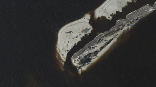
On September 29, the National Geodetic Survey (NGS) began collecting aerial damage assessment images in the aftermath of Hurricane Ian. Imagery is being collected in specific areas by NOAA aircraft, identified by NOAA in coordination with FEMA and other state and federal partners. Collected images are available to view online via the NGS aerial imagery ...
oceanservice.noaa.gov

Maxar Offering New Space-monitoring Service To Help Track Objects In Orbit

Maxar Technologies, an operator of high-resolution Earth imaging satellites, has received regulatory approval to use its satellites to monitor the space environment and sell that data commercially. Having a license to offer non-Earth imagery allows commercial remote sensing satellites to observe objects such as other satellites and orbital debris. Maxar is looking to use this ...
spacenews.com

Biden Administration Launches Portal To Help Communities Assess Exposure To Climate Hazards

Today, the Biden-Harris Administration in partnership with Department of Commerce’s National Oceanic and Atmospheric Administration (NOAA) and the Department of the Interior (DOI) jointly launched a new website to help communities across the nation understand the real-time climate-related hazards in their area, analyze projected long-term exposure to those hazards, and identify federal funds to support ...
noaa.gov
A New Satellite Monitors Lightning Strikes And Fog To Map Weather Risks Faster

A New Satellite Monitors Lightning Strikes And Fog To Map Weather Risks Faster

Nine of the 20 largest wildfires in California in the last 110 years were started by lightning strikes, including the devastating Lightning Complex fires in August 2020 that burned more than 750,000 acres in and around the Bay Area. Between 2017 and 2021, Northern California has witnessed 2,093 lightning-induced wildfires. And research now suggests that ...
baynature.org