Geomaticians

Natural Hazard

Geospatial Intelligence In Disaster Response The Turkey-Syria Earthquakes

Geospatial Intelligence In Disaster Response: The Turkey-Syria Earthquakes

European Space Imaging has acquired high-resolution satellite imagery of affected areas in Turkey using GeoEye-1, including Islahiye, Nurdağı and Bahçe. The images reveal damaged residential areas, temporary tents set up on soccer fields, and heavy congestion on roads and highways, many of which have been closed due to earthquake damage. The United Nations Satellite Centre ...
gim-international.com
Angola Launches The Drought Decision Support Projec

Angola Launches The Drought Decision Support Project

On 26 January 2023, the Ministry of Telecommunications, Information Technologies and Social Communications (MINTTICS), the National Space Programme Management Office (GGPEN), in collaboration with the Massachusetts Institute of Technology (MIT), and the Space Enabled Research Group of the MIT Media Lab, inaugurated the “Support System for Policies to Combat Drought in Southern Angola” project. The ...
africanews.space
Techos Verdes Reducirían Impacto De Las Inundaciones En Manizale

Techos Verdes Reducirían Impacto De Las Inundaciones En Manizales

Aunque para drenar las aguas lluvias, las ciudades disponen de sistemas de alcantarillado, en épocas como la actual, donde el Fenómeno de La Niña ha incrementado el porcentaje de estas, las inundaciones aumentan su frecuencia y magnitud. Otro aspecto que influye en esta problemática es el aumento de la impermeabilización del suelo vinculado al proceso ...
agenciadenoticias.unal.edu.co
Fire Hazard Map Review Period Extended Following Cal Cities’ Advocac

Fire Hazard Map Review Period Extended Following Cal Cities’ Advocacy

The California Department of Forestry and Fire Protection (Cal FIRE) has granted stakeholders an additional 60 days to comment on the state’s draft Fire Hazard Severity Zone Map for rural, unincorporated areas (State Responsibility Area). The move was made in response to a request for more time and clarity from the League of California Cities ...
calcities.org
Grazer Forscher Stellen Schwere Dürre In Europa Fes

Grazer Forscher Stellen Schwere Dürre In Europa Fest

Kernstück des EU-Projekts, von dem die TU Graz wesentlicher Bestandteil ist, sind Zwillingssatelliten namens “Tom und Jerry”. In einer polaren Umlaufbahn in knapp 490 Kilometern Höhe umkreisen die Satelliten die Erde und liefern den Geodätinnen und Geodäten der TU Graz dabei die Daten aus dem Weltall, die sie für die Bemessung des Grundwasserspeichers brauchen. Das ...
meinbezirk.at

Une Plateforme Logicielle Pour Une Gestion De Crise Plus Efficace

Puma-X a l’ambition de faciliter la communication entre tous les outils de gestion de crise, des prévisions météorologiques aux automates d’appel. L’outil a été testé par la ville de Cannes au mois de janvier. L’outil dispose d’un PCS dynamique couplé à la cartographie 3D, d’un traitement en temps réel des données structurées et non structurées ...
lagazettedescommunes.com

Topcon Provides GNSS Correction Services In California

In response to recent disaster declarations throughout California, Topcon Positioning Systems is offering free access to its global navigation satellite system (GNSS) correction services network to essential emergency response agencies and personnel in designated disaster areas. “The challenge for a lot of these companies, services and agencies that come into disaster areas is they don’t ...
geospatialworld.net

OGC Calls For Participation In Its Next Pilot To Improve Disaster Management And Response

The Open Geospatial Consortium (OGC) is Calling For Participants in the OGC Disaster Pilot 2023. Funding is available. Responses are due by February 17, 2023. The goal of the Disaster Pilot 2023 is to further improve the ability of key decision makers and responders to discover, manage, access, qualify, share, and exploit location-based information in ...
directionsmag.com

Intermap Announces New Flood Modelling Initiative In Thailand

Intermap Technologies announced the development of a flood modelling initiative and enhanced Digital Elevation Model (DEM) datasets in Thailand. Using a combination of satellite imagery, radar data and ancillary inputs, Intermap will create an extensive, detailed flood map and precision elevation model for the greater Bangkok area. Bangkok itself is sinking due to urban development ...
geospatialworld.net
Este Nuevo Mapa De Protección Civil Te Informa De Las Alertas Que Hay En Tu Zona En Tiempo Real Lluvias Torrenciales Y Más

Este Nuevo Mapa De Protección Civil Te Informa De Las Alertas Que Hay En Tu Zona En Tiempo Real: Lluvias Torrenciales Y Más

Esta nueva herramienta da visibilidad a la Red de Alerta Nacional (RAN) a través de un visor que se encuentra en una página web accesible desde un ordenador o un dispositivo móvil. Al momento de abrir la página se verá un mapa de toda España con todas las alertas que haya activas en ese momento ...
genbeta.com

Previsico Leverages Next-gen Satellite To Enhance Flood Alerts

Live flood alert InsurTech platform Previsico has partnered with the new €4.3bn Meteosat Third Generation satellite system. This new system will allow Previsico to be more accurate and timelier with flood warnings, providing insurers and property owners with more time to mitigate flood impacts. The first satellite of the new generation was launched on 13 ...
fintech.global
La NASA Se Interesa Por Una App Diseñada En Zaragoza Para Predecir Los Incendio

La NASA Se Interesa Por Una App Diseñada En Zaragoza Para Predecir Los Incendios

Un simulador de incendios forestales diseñado en Zaragoza por un grupo de jóvenes ingenieros e informáticos, se ha convertido en finalista en un concurso de ideas convocado por la NASA. Con esta aplicación han conseguido ser uno de los 35 equipos de todo el mundo que han llegado a la final del ‘NASA Space Apps ...
cope.es

Investigadores De La UAT Crean Sistema Para Detectar Sequía En Tamaulipas, Así Es El Proyecto

Un proyecto sobre la disponibilidad de agua para Tamaulipas y que recoge datos de 30 años a la fecha de nuestra entidad, es desarrollado por investigadores de la Universidad Autónoma de Tamaulipas (UAT). Se trata del Sistema de Información Climatológica y de Riesgos para Tamaulipas (Sicret), que, entre otras herramientas, posibilita construir un sistema de ...
elsoldetampico.com.mx

NASA Has Lost Contact With A Hurricane-watching Satellite

NASA is working to reestablish contact with one of the eight spacecraft that make up its Cyclone Global Navigation Satellite System (CYGNSS) constellation, which monitors hurricanes. CYGNSS is the first space-based system to collect frequent measurements of wind speeds from the ocean’s surface near the eye of storms such as tropical cyclones, typhoons and hurricanes. ...
space.com

Hexagon And OSASI Technos Partner To Develop Disaster Management And Prediction Solutions

Hexagon’s Safety, Infrastructure & Geospatial division and OSASI Technos Inc. have announced a partnership to deliver next-generation disaster management and monitoring solutions. Using 3D visualization capabilities, governments will be able detect, predict and simulate impending disasters, enabling them to better plan for and respond to impending disasters, enabling them to better plan for and respond ...
geospatialworld.net
Tsunami Warning Systems Improved Using Signals From Earth’s Ionosphere

Tsunami Warning Systems Improved Using Signals From Earth’s Ionosphere

The study, ‘Spectral Characteristics of Ionospheric Disturbances Over the Southwestern Pacific From the 15 January 2022 Tonga Eruption and Tsunami,’ explores how evidence from the ionosphere explains why the tsunami grew larger and travelled faster than tsunami forecasts predicted. Due to tsunamis being an extremely rare natural disaster, current tsunami warning systems are far from ...
innovationnewsnetwork.com
Ferramenta Desenvolvida Pelo Cemaden E O Programa Servir-amazonia Prevê Inundações Com Antecedência

Ferramenta Desenvolvida Pelo Cemaden E O Programa Servir-amazonia Prevê Inundações Com Antecedência

Com a cooperação técnica firmada há um ano entre o Cemaden/MCTI, a Aliança Bioversity-CIAT e o Programa Servir-Amazonia (do Programa Servir-Global), as instituições vêm desenvolvendo os serviços de informação para o monitoramento hidrometeorológico, modelagem de inundações e deslizamentos de terra e lançaram a ferramenta Hydroview para previsão de inundações no Brasil. O lançamento do serviço ...
conexaoto.com.br
Profesora Y Alumno Idean Aplicación Para Registrar Distintos Tipos De Incendios

Profesora Y Alumno Idean Aplicación Para Registrar Distintos Tipos De Incendios

Una profesora y un estudiante de la Universidad de Guanajuato (UG), del Departamento de Ingeniería Geomática e Hidráulica, crearon una aplicación que realiza el reporte de diferentes tipos de incendios, esta “app” vincula, directamente, los reportes a las distintas instituciones encargadas de controlar y apagar el fuego. La investigadora de la Universidad de Guanajuato explicó ...
lasillarota.com
City Sprawl Responsible For Acceleration Of Deep Landslide Movement, Finds Study

City Sprawl Responsible For Acceleration Of Deep Landslide Movement, Finds Study

An international team of researchers has found that an acceleration in movement of a deep landslide beneath the city of Bukavu, in the Democratic Republic of the Congo, is due to city sprawl, not natural forces. In their study, published in the journal Nature Geoscience, the group analyzed satellite imagery and aerial photographs of the ...
phys.org

Dissesto Idrogeologico: Nuovi Modelli Prevedono L’impatto Delle Colate

Un team di ricercatori dell’ENEA ha sviluppato un nuovo approccio per prevedere l’area di propagazione e l’intensità delle colate rapide, un particolare tipo di frane veloci altamente distruttivo, e sta testando nuove metodologie per stimarne le soglie di innesco in base al contenuto di acqua dei terreni di copertura. Le innovazioni volte al la produzione ...
corrierenazionale.it

¡Con Tecnología De La NASA! Plataforma De Senamhi Permitirá Mejorar Pronóstico De Inundaciones

El Servicio Nacional de Meteorología e Hidrología del Perú (Senamhi) anunció el lanzamiento de Senamhi GEOGloWS, una plataforma que cuenta con tecnología de la Administración Nacional de Aeronáutica y del Espacio (NASA). Con los datos obtenidos se espera optimizar el pronóstico de inundaciones a nivel nacional. Este nuevo sistema ha sido personalizado con las condiciones ...
larepublica.pe

Satellite Imagery Monitors World’s Largest Active Volcano Eruption In Hawaii

Mauna Loa volcano began erupting in Moku‘āweoweo Caldera on November 27, 2022. A long-feared Mauna Loa eruption has now disrupted several flights and triggered in an all-hands emergency response. As of now there are no mandatory evacuations in place, but shelters have opened to accommodate those opting to leave voluntarily. The eruption comes after months ...
geospatialworld.net

Using Satellites For Faster Flood Information

Researchers at The University of Queensland have used satellites with radar imaging sensors to see through clouds and map flooding and say the technique could provide faster, more detailed information to keep communities safe. Professor Noam Levin from UQ’s School of Earth and Environmental Sciences said the project combined images from optical satellites with information ...
sciencedaily.com

China Deploys Teledyne Product For Post Disaster Recovery Efforts

Teledyne Geospatial announced that the State Key Laboratory of Geohazard Prevention and Geoenvironment Protection in China’s Sichuan province recently deployed the Optech Galaxy T2000 to aid in the post disaster recovery and reconstruction phase after a 6.8 magnitude earthquake caused heavy damage to buildings, roads and other infrastructure in the Luding area. Eight days after ...
geospatialworld.net
China Launches Yaogan-34 Remote-sensing Satellite For Land Surveys, Disaster Prevention

China Launches Yaogan-34 Remote-sensing Satellite For Land Surveys, Disaster Prevention

China sent a new remote-sensing satellite of the Yaogan-34 series into space from the Jiuquan Satellite Launch Center in northwest China on Tuesday morning, marking the launch of the100th satellite developed by the 509th Research Institute of the Shanghai Academy of Spaceflight Technology. It will mainly be used in land resources surveys and disaster prevention. ...
globaltimes.cn

Un Nuevo Sistema Combina Imágenes Térmicas Aéreas Y Terrestres Para Estudiar La Sequía En Árboles

Un equipo de científicos del Instituto de Agricultura Sostenible (IAS-CSIC), el Centro de Investigaciones sobre Desertificación (CIDE-CSIC-UV-GV), el Centro de Edafología y Biología Aplicada del Segura (CEBAS-CSIC) y la Universidad de Melbourne en Australia ha desarrollado un sistema que cuantifica el estado hídrico de los árboles a partir de la combinación de fotografías térmicas tomadas ...
iagua.es
Google Expands AI-powered Flood Detection And Wildfire Systems

Google Expands AI-powered Flood Detection And Wildfire Systems

For the last several years, Google has been using artificial intelligence to develop a system that can predict floods. It has also been working on wildfire tracking tools. Ahead of the COP27 climate conference taking place next week, the company announced that it is expanding those tools. First, Google says it will offer flood forecasts ...
engadget.com
Deep Learning Underlies Geographic Dataset Used In Hurricane Response

Deep Learning Underlies Geographic Dataset Used In Hurricane Response

As Hurricane Fiona made landfall as a Category 1 storm in Puerto Rico on Sept. 18, 2022, some areas of the island were inundated with nearly 30 inches of rain, and power to hundreds of thousands of homes was knocked out. Only 10 days later, Hurricane Ian, a Category 4 storm and one of the ...
newswise.com

Digital Solutions Help Rural Pakistan

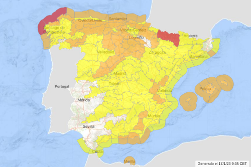
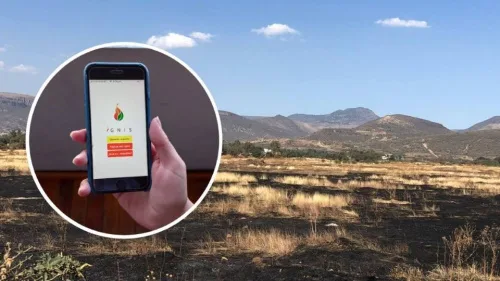
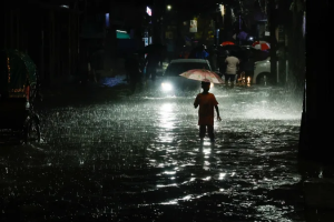
As flash floods recede in Pakistan, the country welcomes the first smart IoT (Internet of Things) farm in Rawalpindi. Satellite navigation autopilot, robotic fertiliser applicator, agricultural UAV, climate and soil monitoring stations, solar-powered water pump…the deluge-ravaged land is recovering by virtue of digital solutions. “This is just a beginning,” Liu Yang Sloan, Secretary General of ...
tribune.com.pk

New Mapping Techniques Rapidly Identified Hurricane Damage Across All Of Florida. Here’s How They Work

Hurricane Ian left an extraordinarily broad path of destruction across much of South Florida. That was evident in reports from the ground, but it also shows up in satellite data. Using a new method, our team of spatial and environmental analysts was able to quickly provide a rare big picture view of damage across the ...
fastcompany.com