Geomaticians

Natural Hazard

New 3D Maps Reveal Hundreds Of Ancient Landslides South Of Auckland

New 3D Maps Reveal Hundreds Of Ancient Landslides South Of Auckland

Just-released maps have revealed hundreds of ancient landslides around Pukekohe, while offering a multi-dimensional view of the region’s active faults and volcanic features. Capturing more than 830 square kilometres, from Manukau Harbour’s southern shoreline to the lower Waikato River, the new GNS Science-produced maps show Auckland’s rolling southern landscapes as they’ve never been seen. It ...
nzherald.co.nz

Synspective And Thaicom Partner On Disaster Response In Southeast Asia

Imagery startup Synspective and regional operator Thaicom are partnering to jointly offer synthetic aperture radar (SAR) for disaster response in Thailand. The two companies announced Tuesday they plan to offer a solution to government, defense, agriculture, and finance sectors in Thailand, with Synspective’s SAR technology and Thaicom’s knowledge of the satellite and space sector in ...
satellitetoday.com
Brasil Queimou Área Equivalente A Colômbia E Chile Juntosentre 1985 E 2022

Brasil Queimou Área Equivalente A Colômbia E Chile Juntosentre 1985 E 2022

Um novo mapeamento da superfície queimada pelo fogo no Brasil revela que a área queimada entre 1985 e 2022 foi de 185,7 milhões de hectares, ou 21,8% do território nacional. A média anual alcança 16 milhões de hectares/ano, ou 1,9% do Brasil. São extensões comparáveis a países: no caso do acumulado em 38 anos, a ...
blogdopedlowski.com
Heigit Disaster Portal Erfolgreich Nach Erdbeben In Der Türkei Und In Syrien Eingesetzt

Heigit Disaster Portal Erfolgreich Nach Erdbeben In Der Türkei Und In Syrien Eingesetzt

Das Heidelberg Institute for Geoinformation Technology (HeiGIT) hat im Februar 2023 mit Input des GIS-Team Nahost der Médecins Sans Frontières (Ärzte ohne Grenzen/MSF) sein Disaster Portal für die betroffene Region eingerichtet. Das Portal ist ein wichtiges Werkzeug für Hilfsorganisationen wie MSF und hilft mit seinen Echtzeitinformationen, die Einsätze der Helfer:innen vor Ort effizient zu planen. ...
idw-online.de
AI Project Aims To Use Tech To Predict Landslides, Illegal Mining, Erosion And Emissions In Irish Bogs

AI Project Aims To Use Tech To Predict Landslides, Illegal Mining, Erosion And Emissions In Irish Bogs

Irish boffins are exploring how artificial intelligence can be used to predict threats to Irish peat bogs and their impact on the climate. Ireland’s national centre for applied AI, CeADAR, has teamed up with the National Parks and Wildlife Service and Science Foundation Ireland Research Centre in Applied Geosciences iCRAG for a €200k project, AI2Peat. ...
irishmirror.ie
Restoring Nature Can Lead To Fewer Road Repairs, Alberta Study Shows

Restoring Nature Can Lead To Fewer Road Repairs, Alberta Study Shows

‘Tis the season for flooding and road washouts. Not only can they create inconvenient, time-consuming detours and safety risks, but they’re also expensive to repair. And as climate change brings more extreme weather, including heavier rains, the cost of adapting infrastructure is expected to go up, along with the cost of repairing damage. But a ...
cbc.ca
디지털 트윈·AI 기반 도시침수 예보·신속 대응체계 구축

디지털 트윈·AI 기반 도시침수 예보·신속 대응체계 구축

과학기술정보통신부와 환경부는 광주광역시, 경상북도, 경상남도와 가상모형(디지털 트윈), 인공지능(AI) 등 첨단 디지털 기술을 활용한 도시침수 예보체계 구축을 위해 12일 한강홍수통제소(서울 서초구 소재)에서 업무협약을 체결했다. 가상모형(Digital Twin)은 가상세계(Digital)에 실제 사물의 물리적 특징을 동일하게 반영한 쌍둥이(Twin)를 3D 모델로 구현하고, 실제 사물과 실시간으로 동기화한 시뮬레이션을 거쳐 관제·분석·예측 등 해당 사물에 대한 현실 의사결정에 활용하는 기술이다.
koit.co.kr

Mapeamento Com Drones Vai Ajudar Na Prevenção A Desastres Meteorológicos

O Governo do Estado do Espírito Santo, por meio do Instituto Jones dos Santos Neves (IJSN) e da Defesa Civil Estadual, está desenvolvendo um projeto que vai contribuir para a prevenção e o enfrentamento de desastres meteorológicos. É o aerolevantamento de território com uso de drones. A iniciativa prevê o mapeamento tridimensional do território, permitindo ...
es.gov.br
Afet Sağlık Haritası Hizmete Girdi

Afet Sağlık Haritası Hizmete Girdi

MEDAK, Kahramanmaraş merkezli depremlerin etkilediği illerde sağlık kuruluşları hakkında sahadaki insanların doğru ve güncel olarak bilgilendirilmesi için çalışma başlattı. Bu kapsamda dernek, deprem bölgesinde görev alan tüm yabancılar da dahil resmi ve özel yardım yardım kuruluşlarıyla temasa geçerek, gerek kendi görevlileri gerekse diğer kurumların yetkili kişileri tarafından illerde hizmet veren sabit veya gezici tüm sağlık ...
yenicaggazetesi.com.tr
Deutschland Verlor In Den Letzten Zwei Jahrzehnten Durchschnittlich 760 Millionen Tonnen Wasser Pro Jahr

Deutschland Verlor In Den Letzten Zwei Jahrzehnten Durchschnittlich 760 Millionen Tonnen Wasser Pro Jahr

Die letzten fünf Jahre in Deutschland waren von massiven Sommerdürren geprägt. Sehr viel Wasser ging verloren. Nur: Wie hoch die Verluste genau waren und ob sich daraus ein Trend für die Zukunft ableiten lässt, sind nach wie vor offene Fragen. Ein Team des Deutschen GeoForschungsZentrums (GFZ) hat nun mit Kolleg:innen die Jahre 2002-2022 genauer untersucht. ...
idw-online.de

Investigadores Da Universidade De Évora Dão Contributos Para Planos De Gestão De Risco De Inundações!

Um dos pilares do Laboratório Associado CHANGE – Instituto para as Alterações Globais e Sustentabilidade, coordenado pelo MED, da Universidade de Évora, é a produção de conhecimento que apoie o desenvolvimento de políticas públicas inovadoras. Investigadores do MED, uma das unidades de investigação e desenvolvimento que constituem o CHANGE, desenvolveram um trabalho que foi tomado ...
radiocampanario.com
FutureTales LAB And ESRI Set Up “Urban Hazard Studio” Data Hub

FutureTales LAB And ESRI Set Up “Urban Hazard Studio” Data Hub

FutureTales LAB by MQDC, a futurology research centre, is collaborating with ESRI (Thailand), a leader in location intelligence and geo-informatics with ArcGIS software, to set up the “Urban Hazard Studio” data hub to study Greater Bangkok’s flood risks. The hub will analyse, evaluate, and share information to alert people and society so all sectors prepare ...
bangkokpost.com
How AI Is Saving Homes And Lives In California During Wildfire Season

How AI Is Saving Homes And Lives In California During Wildfire Season

In California, extreme heat and drought conditions now occur at regular intervals, drying out grassland, pine needles and other foliage, adding to the century-old tinderbox that stokes these enormous fires. However, the state is now harnessing a powerful tool to dampen the effects of these fires, namely artificial intelligence, and specifically machine learning. The abundance ...
zdnet.com
Detailed Images From Space Offer Clearer Picture Of Drought Effects On Plants

Detailed Images From Space Offer Clearer Picture Of Drought Effects On Plants

In 2022, Terrer received seed grant funding from the Abdul Latif Jameel Water and Food Systems Lab (J-WAFS) to produce drought monitoring systems for farmers. The project is leveraging a new generation of remote sensing devices to provide high-resolution plant water stress at regional to global scales. Terrer and Wenzhe Jiao collect data from remote ...
news.mit.edu
Identify Points Of Threat Of Landslides In Three Roads Of The Country

Identifican Puntos De Amenaza De Deslizamientos En Tres Vías De País

El docente desarrolló una metodología que estima las eventuales amenazas de taludes, información que serviría para diseñar alertas tempranas en estos proyectos de infraestructura. El proceso consiste en cuatro fases del tratamiento de la imagen. En la primera se localiza el tramo o la ruta a investigar mediante Google Earth; en la segunda, con el ...
agenciadenoticias.unal.edu.co
Restoration Of Hatay's Damaged Landmarks Made Via 3D Modeling

Restoration Of Hatay’s Damaged Landmarks Made Via 3D Modeling

Teams from Istanbul University started their investigations of historical buildings that were severely damaged. Working in separate groups in the field, the teams make measurements using the photogrammetry technique with the help of drones and performing lidar mapping. “… The first step is the three-dimensional (3D) visualization of the surrounding buildings and the most important ...
dailysabah.com

Bilim Insanları Afet Bölgesinin Röntgenini Çekiyor! Belirlenen Noktalara GPS Cihazları Ve Sabit Istasyon Kurulacak

7.7‘lik büyük felaket sonrası TÜBİTAK’ın çağrısıyla afet bölgesine çıkarma yapan bilim insanları, 10 ilin röntgenini çekiyor. Fay hareketlerinin nasıl değiştiğini gözlemleyebilmek amacıyla bölgeye 3 ekibini gönderen Boğaziçi Üniversitesi Kandilli Rasathanesi Jeodezi Anabilim Dalı öğretim üyesi Prof. Dr. Semih Ergintav, “Belirlenen noktalara GPS cihazları ve sabit istasyon kuracağız. Amacımız bundan sonraki nesillere fay hareketliliği ile ilgili ...
sabah.com.tr
New Technique Maps Large-scale Impacts Of Fire-induced Permafrost Thaw In Alaska

New Technique Maps Large-scale Impacts Of Fire-induced Permafrost Thaw In Alaska

Researchers from Florida Atlantic University, in collaboration with the United States Army Corps of Engineers Cold Regions Research & Engineering Laboratory, and Alaska Ecoscience, systematically analyzed the effects of six large fires that have occurred since 2000 on the Tanana Flats lowland in interior Alaska on land cover change, vegetation dynamics, and terrain subsidence, or ...
eurekalert.org
Erdbeben In Türkei Und Syrien Hat Gelände Langfristig Verändert

Erdbeben In Türkei Und Syrien Hat Gelände Langfristig Verändert

Nun vermeldet die Europäische Raumfahrtbehörde (ESA), dass die Erdbeben offenbar das Terrain in der Katastrophenregion langfristig verändert haben. So habe sich die Küstenstadt İskenderun stellenweise abgesenkt, was zu Überschwemmungen geführt habe. Zudem drohen in der Region zahlreiche Hänge abzurutschen. Nach dem Beben stellten 17 Weltraumorganisationen insgesamt 350 Satellitenbilder aus der Krisenregion zusammen, damit die Schäden ...
spektrum.de
Un Algoritmo Permite Organizar La Ayuda Humanitaria Después De Una Catástrofe Natural

Un Algoritmo Permite Organizar La Ayuda Humanitaria Después De Una Catástrofe Natural

Los terremotos que asolaron a Nepal entre abril y mayo de 2015 mataron a más de 9.000 personas, dejaron otras 22.000 heridas y afectaron a casi un millón de familias. A los supervivientes les quedó un país bajo escombros y, en las áreas más perjudicadas, alrededor de un millón de personas se quedaron sin agua ...
elpais.com

Depremzedelerin Yerini Gösteren Portal

Başarsoft, Kahramanmaraş depreminde kullanılmak üzere “Depremde Yardım İhtiyaçları Haritalandırma Portalı” kurdu. Portal, depremde yollar ve binaların yıkıldığı, adres tabelalarının kaybolduğu durumlarda koordinata dayalı ulaşım sağlıyor ve yardım ekiplerini yardım istenen enkazlara yönlendiriyor. Depremin ilk anından itibaren Başarsoft Ankara’dan 40 kişilik bir ekip Twitter’a ve diğer sosyal medya ağlarına düşen yardım taleplerini tarayarak adresleri ve talep ...
dunya.com
Bakanlık Deprem Bölgesinde Uydu Ve İha'larla Hasar Tespiti Yapıyor

Bakanlık Deprem Bölgesinde Uydu Ve İha’larla Hasar Tespiti Yapıyor

Çevre, Şehircilik ve İklim Değişikliği Bakanlığı’nca, Kahramanmaraş merkezli depremlerden etkilenen 10 ilde insansız hava aracı (İHA), dron ve Göktürk uydu görüntüleri ile dijital şehir ikizi görüntüleri karşılaştırılarak binalarda ön hasar tespit çalışmalar yürütülüyor. Bakanlıktan yapılan yazılı açıklamada, Coğrafi Bilgi Sistemleri Genel Müdürlüğü koordinasyon merkezinden yürütülen çalışmalar kapsamında 81 ilde tamamlanan 3 boyutlu dijital şehir ikizi ...
trthaber.com
İhtiyaç Haritası'nın Afet Koordinasyon Platformu Afet Haritası

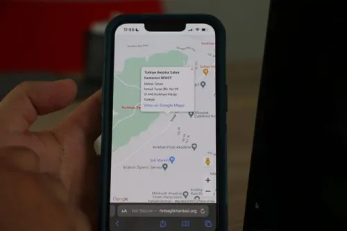
İhtiyaç Haritası’nın Afet Koordinasyon Platformu: Afet Haritası

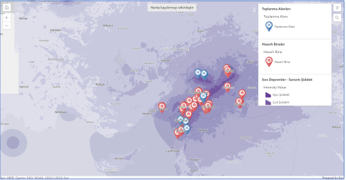
Afet Haritası, destek ve kurtarma çalışmaları için yerel yetkililer, STK’lar, şirketler ve gönüllüler gibi çeşitli aktörler arasında etkili iletişim ve koordinasyon sorunlarını çözmeye odaklanıyor. Destek sağlayan tüm aktörleri gerçek zamanlı olarak takip edebilen Afet Haritası, aynı zamanda Türkiye’nin afet bölgelerindeki ihtiyaçları belirlemek ve tedarik etmek için kullanıcıları hızlı bir şekilde harekete geçiriyor. Kısacası Afet Haritası, ...
webrazzi.com
Geospatial Intelligence In Disaster Response The Turkey-Syria Earthquakes

Geospatial Intelligence In Disaster Response: The Turkey-Syria Earthquakes

European Space Imaging has acquired high-resolution satellite imagery of affected areas in Turkey using GeoEye-1, including Islahiye, Nurdağı and Bahçe. The images reveal damaged residential areas, temporary tents set up on soccer fields, and heavy congestion on roads and highways, many of which have been closed due to earthquake damage. The United Nations Satellite Centre ...
gim-international.com
Angola Launches The Drought Decision Support Projec

Angola Launches The Drought Decision Support Project

On 26 January 2023, the Ministry of Telecommunications, Information Technologies and Social Communications (MINTTICS), the National Space Programme Management Office (GGPEN), in collaboration with the Massachusetts Institute of Technology (MIT), and the Space Enabled Research Group of the MIT Media Lab, inaugurated the “Support System for Policies to Combat Drought in Southern Angola” project. The ...
africanews.space
Techos Verdes Reducirían Impacto De Las Inundaciones En Manizale

Techos Verdes Reducirían Impacto De Las Inundaciones En Manizales

Aunque para drenar las aguas lluvias, las ciudades disponen de sistemas de alcantarillado, en épocas como la actual, donde el Fenómeno de La Niña ha incrementado el porcentaje de estas, las inundaciones aumentan su frecuencia y magnitud. Otro aspecto que influye en esta problemática es el aumento de la impermeabilización del suelo vinculado al proceso ...
agenciadenoticias.unal.edu.co
Fire Hazard Map Review Period Extended Following Cal Cities’ Advocac

Fire Hazard Map Review Period Extended Following Cal Cities’ Advocacy

The California Department of Forestry and Fire Protection (Cal FIRE) has granted stakeholders an additional 60 days to comment on the state’s draft Fire Hazard Severity Zone Map for rural, unincorporated areas (State Responsibility Area). The move was made in response to a request for more time and clarity from the League of California Cities ...
calcities.org
Grazer Forscher Stellen Schwere Dürre In Europa Fes

Grazer Forscher Stellen Schwere Dürre In Europa Fest

Kernstück des EU-Projekts, von dem die TU Graz wesentlicher Bestandteil ist, sind Zwillingssatelliten namens “Tom und Jerry”. In einer polaren Umlaufbahn in knapp 490 Kilometern Höhe umkreisen die Satelliten die Erde und liefern den Geodätinnen und Geodäten der TU Graz dabei die Daten aus dem Weltall, die sie für die Bemessung des Grundwasserspeichers brauchen. Das ...
meinbezirk.at