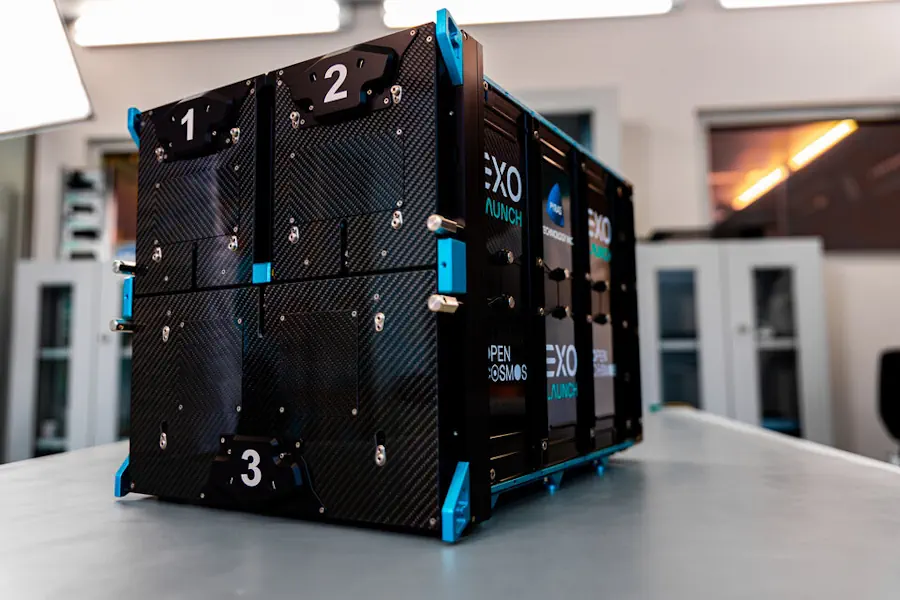
Geomaticians

Marine

MSPglobal 2.0 Is Co-Developing A Data Toolbox To Support Countries In Developing Their Own Spatial Data Infrastructure

On the 24th and 25th of April 2024, the MSPglobal 2.0 initiative facilitated an online workshop to consult experts on ocean data and Spatial Data Infrastructure. The project aims to co-develop a Data Toolbox to support countries in developing their own SDI for MSP. About 30 participants from across the globe joined the sessions to ...
ioc.unesco.org

Iceye Launches Radar Satellite Service To Monitor The High Seas

Iceye, a company that builds and operates a constellation of microsatellites equipped with synthetic aperture radar (SAR) sensors, has launched a new maritime surveillance product called Ocean Vision. The service, announced March 7, aims to provide comprehensive monitoring of the world’s oceans. SAR satellites detect the signatures of vessels that stand out against the dark ...
spacenews.com
New Mapping Method Developed For Critical Marine Habitat

New Mapping Method Developed For Critical Marine Habitat

Researchers at The University of Western Australia have led the development of a new technique for accurately mapping shallow and coastal marine habitats. Dr Sharyn Hickey and Dr Stan Mastrantonis, from UWA’s School of Agriculture and Environment, School of Biological Sciences and Oceans Institute, were co-authors of the research published in the ISPRS Journal of ...
uwa.edu.au

Al Via La Prima Mappa Delle Coste Italiane

Il progetto MER è la prima campagna di monitoraggio delle coste dell’Italia. L’intento è fornire dati ad altissima risoluzione volti a migliorare il processo decisionale dei governi locali per la protezione degli habitat e delle specie marine di interesse conservazionistico. A gestire il bando l’ISPRA che ha assegnato al consorzio guidato da Fugro l’azione di ...
canaleenergia.com
Projeto Biogeomar Convida O Público A Fotografar Animais E Plantas Marinhos

Projeto Biogeomar Convida O Público A Fotografar Animais E Plantas Marinhos

Onde estão as espécies do litoral brasileiro? Buscando conhecer melhor a biodiversidade marinha brasileira, o Programa BioGeoMar acaba de lançar a campanha de ciência cidadã BioBlitz Verão 2024. Nela, o público é convidado a explorar, identificar e registrar a vida dentro e fora da água, sejam animais ou plantas, encontrados em praias, mergulhos ou em ...
ufpr.br

NGA Issues Million Dollar Challenge To Stop Illegal Fishing

The National Geospatial-Intelligence Agency (NGA) and the National Security Innovation Network (NSIN) are looking for people with innovative solutions to help stop illegal fishing. This new challenge has a million-dollar prize pool. Illegal, unreported and unregulated fishing is a critical issue threatening the sustainability of marine ecosystems. It contributes significantly to the decline and potential ...
fox2now.com

Croatia’s National Map Of Maritime Habitats Launched

This marked the culmination of the project “Mapping Coastal and Submarine Habitats in the Adriatic Sea under National Jurisdiction,” spearheaded by the Ministry of Economy and Sustainable Development of the Republic of Croatia (MINGOR) in collaboration with a consortium of over 200 experts. Institute of Oceanography and Fisheries said that the project aimed to enhance ...
croatiaweek.com
World’s First Map Of Industrial Ocean Use

World’s First Map Of Industrial Ocean Use

Illegal fishing practices through spoofing tracking devices in ships have become a common practice in the industrial use of our oceans. A new study published in the journal Nature corroborates the trend and offers a view of the changing oceanic activities and landscape. Led by Global Fishing Watch, a company founded by Google, the study ...
geospatialworld.net
China Delivers 1st 'Floating Oil Factory' With Digital Twin Technology

China Delivers 1st ‘Floating Oil Factory’ With Digital Twin Technology

China has delivered its first “floating oil factory” with land-sea integrated operation system, marking a new breakthrough in the country’s application of the digital twin technology. Haiyang Shiyou 123 (Offshore Oil 123) ship is a floating production storage and offloading (FPSO) unit that can process oil and gas on the sea, saving the process of ...
news.cgtn.com

Largest Global Map Of Marine Life Protections Released

ProtectedSeas Navigator—the first global map of the world’s marine life regulations and their boundaries is now available. Navigator is a free, interactive map of over 21,000 marine protected and managed areas across 220 countries and territories and in over 25 languages. Navigator offers a global view of marine life protections to help inform progress towards ...
eurekalert.org