Geomaticians

LST

Mapping Urban Heat From The Ground Up

Mapping Urban Heat From The Ground Up

Just one year ago, scientists at the U.S. Department of Energy’s (DOE) Brookhaven National Laboratory assembled a unique mobile observatory for surveying the climate in urban environments. The completely off-the-grid platform maintained by Brookhaven’s Center for Multiscale Applied Sensing (CMAS) employs a suite of instruments to measure atmospheric conditions at fixed locations in individual neighborhoods ...
phys.org
Space Data Tracks Record-breaking UK Heatwave

Space Data Tracks Record-breaking UK Heatwave

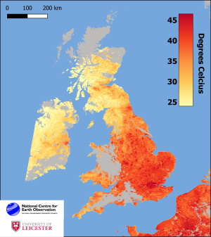
Leicester scientists affiliated with the National Center for Earth Observation (NCEO), headquartered at Space Park Leicester, have mapped measures of land surface temperature—topping out at 52°C—as measured by the pair of Sentinel-3 satellites in orbit more than 800km (500 miles) above Earth. Their map shows the temperature of the Earth’s surface at approximately 10:20 am ...
phys.org
City Heat Extremes Captured By Instrument On The ISS

City Heat Extremes Captured By Instrument On The ISS

An instrument, carried on the International Space Station, has captured the recent land-surface temperature extremes for some European cities, including Milan, Paris and Prague. For ESA, this particular instrument, which is called ECOSTRESS and owned by NASA’s Jet Propulsion Laboratory (JPL), is important because it is helping in the development of a new Copernicus Sentinel ...
phys.org