Geomaticians

LIS

University Of Nevada, Reno Team Develops New Vegetation Mapping Tools

University Of Nevada, Reno Team Develops New Vegetation Mapping Tools

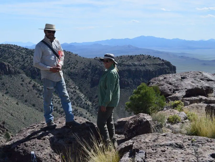
Powerful new digital mapping tools developed by University of Nevada, Reno researchers hold promise to improve management of rangeland, particularly public lands in the far-flung Western United States. The significant improvements in mapping of vegetation enabled by the University’s research provide managers of rangeland, ranchers as well as federal managers of public lands, with better ...
unr.edu
CLCP Develops New Tools To Support Land Protection Decisions In Florida

CLCP Develops New Tools To Support Land Protection Decisions In Florida

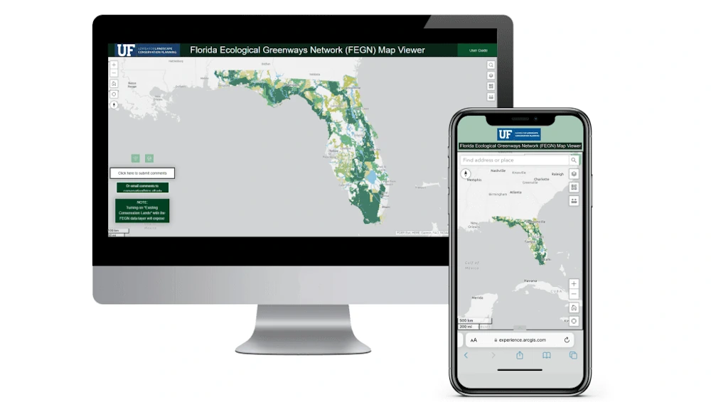
The University of Florida’s Center for Landscape Conservation Planning (CLCP) and GeoPlan Center have developed two new tools to support land protection decisions in Florida – a web map viewer and web-based dashboard for the Florida Ecological Greenway Network (FEGN). The FEGN is a statewide database that identifies and prioritizes a functionally connected statewide ecological ...
dcp.ufl.edu

New PSGA Data Will Help Speed Up Emergency Response Times

A new selection of location datasets, including two new products, have been released today (Thursday 28 March) as part of the Public Sector Geospatial Agreement (PSGA). The new data and products have been delivered by Ordnance Survey (OS) and are set to support customers across a range of markets, including the emergency services, sustainability, land ...
gov.uk

California Is Finally Digitizing Its 100-Year-Old Paper Water Rights

In a Sacramento office building, university students carefully scan pieces of paper that underpin California’s most contentious and valuable water disputes. One by one, they’re bringing pieces of history into the digital era, some a century old and thin as onion skin. The massive undertaking will unmask the notoriously opaque world of California water. Right ...
insider.govtech.com
Biodiversity Survey Tool For Meeting New Net Gain Obligations

Biodiversity Survey Tool For Meeting New Net Gain Obligations

Esri UK partner Temple has created a biodiversity assessment tool, which could assist construction and engineering firms in meeting the biodiversity net gain (BNG) legislation that came into effect in England earlier this year. Environment, planning and sustainability consultancy Temple has joined geographic information system (GIS) software provider Esri UK’s partner network. This allows Temple ...
geplus.co.uk
سامانه اطلس سرمایه‌گذاری كشور رونمایی شد

سامانه اطلس سرمایه‌گذاری كشور رونمایی شد

این مراسم با حضور رئیس سازمان سرمایه‌گذاری و کمک‌های اقتصادی و فنی ایران، رئیس سازمان نقشه‌برداری کشور، “مجتبی توانگر” رئیس کمیته اقتصاد دیجیتال و “عزت الله اکبری” رئیس کمیسیون صنایع و معادن مجلس شورای اسلامی و تعدادی از معاونان وزارت اقتصاد برگزار شد. اطلس سرمایه گذاری در پاسخ به ضرورت موجود اطلس سرمایه گذاری کشور ...
shada.ir
Áncash Realizan Lanzamiento Del Observatorio Territorial Www.Infogel.Pe

Áncash: Realizan Lanzamiento Del Observatorio Territorial Www.Infogel.Pe

En las instalaciones de la Cámara de Comercio de Áncash, se realizó el lanzamiento del Observatorio Territorial INFOGEL, portal web que permite recopilar, analizar y difundir información relevante a través de datos espaciales, para tener conocimiento de lo que acontece en 20 distritos del área de influencia operativa de Antamina. Instituciones públicas de Áncash y ...
ancashnoticias.com

Geo-Tagging Of Properties Mandatory To Avail Property Tax Exemption In Delhi: MCD

Municipal Corporation of Delhi has made geo-tagging of all kinds of properties mandatory to avail of the property tax exemption, an official statement said on Tuesday. If any taxpayer fails to geo-tag their properties by 31 January, they will not be able to avail 10 per cent rebate on lump sum advance payment of tax ...
realty.economictimes.indiatimes.com
Researchers Propose New Method for Large-Scale Urban Building Function Mapping Using Web-Based Geospatial Data

Researchers Propose New Method for Large-Scale Urban Building Function Mapping Using Web-Based Geospatial Data

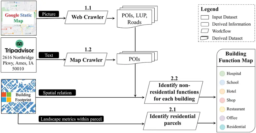
In a pioneering study published in Geo-spatial Information Science, a research group led by Yuyu Zhou from The University of Hong Kong developed an integrated framework that achieves 94% accuracy in mapping building functions across 50 U.S. cities using multi-source web-based geospatial data, offering potential for worldwide application. The team utilized TripAdvisor.com and Google Maps ...
newswise.com

El Proyecto DATAPASS Elabora El Primer Mapa Interactivo Sobre Vivienda Que Integra Las Bases De Organismos Públicos Transfronterizos

El proyecto DATAPASS de cooperación transfronteriza, en el que participa el Gobierno de Navarra y Nasuvinsa-Lursarea, ha elaborado un mapa interactivo que integra las bases de datos de los organismos implicados en el diseño de políticas públicas en ordenación del territorio y urbanismo, en el marco de un estudio sobre vivienda y territorio en el ...
pamplonaactual.com

Casablanca-Anfa : Lancement D’une Vaste Opération De Recensement Des Bâtiments Menaçant Ruine

Un appel d’offres relatif au recensement et à l’expertise des bâtiments menaçant ruine au niveau de la préfecture d’arrondissements de Casa-Anfa a été lancé récemment, à l’initiative de l’Agence nationale pour la rénovation urbaine et la réhabilitation des bâtiments menaçant ruine. Concrètement, cette opération va permettre de recenser et d’expertiser un parc de 5.000 bâtiments ...
lavieeco.com

Greater Noida Authority To Undertake GIS Mapping To Protect Government Land

With a view to protect government land from encroachment in all 124 villages under its jurisdiction, the Greater Noida authority has decided to carry out a geographic information system (GIS) survey soon, officials aware of the matter said. “The survey will determine how much land has been grabbed in each village. After that, the authority ...
hindustantimes.com

In A First, CIDCO To Use AI, Satellite Imagery To Detect Illegal Structures

The City and Industrial Development Corporation (CIDCO for the first time is eyeing the possibility of using automated technology to identify illegal constructions happening in its area. The application that CIDCO plans to develop will enable officials to do extensive area-based study with the help of high resolution satellite imagery. “This technological intervention will supplement ...
hindustantimes.com
Presentan Servicio De “Teledetección Con Drones” Para Digitalizar Y Registrar Información Geoespacial Forestal

Presentan Servicio De “Teledetección Con Drones” Para Digitalizar Y Registrar Información Geoespacial Forestal

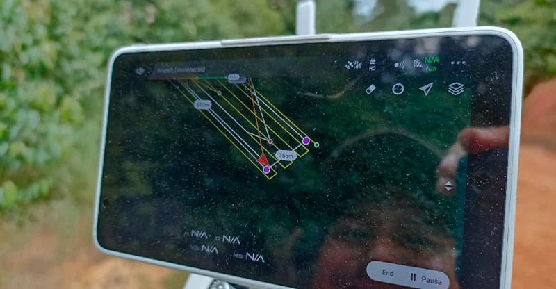
En la Expoamazónica 2023, el Instituto Tecnológico de la Producción (ITP), a través del CITEforestal Maynas, presentó el servicio de “teledetección con drones”, el cual beneficiará al sector forestal de la región de Loreto. Durante la exhibición que albergó a un gran número de participantes, los especialistas del CITE mostraron como dicha tecnología de vanguardia, ...
agroperu.pe

Emater-MG Usa Imagens De Satélite Para Mapear A Citricultura Em Município Do Sul De Minas

A Empresa de Assistência Técnica e Extensão Rural de Minas Gerais (Emater-MG) está realizando um mapeamento pioneiro das áreas ocupadas com a citricultura em Campanha, no Sul do estado. O trabalho de georreferenciamento, que poderá servir de modelo para outros municípios mineiros, é um cruzamento de diversas informações geradas por satélites, por imagens feitas por ...
agenciaminas.mg.gov.br

Esri Canada Acquires Ratio.City To Help Address Canada’s Housing Crisis

Esri Canada, today announced its acquisition of Ratio.City, a Toronto-based urban planning software and data company. This acquisition expands Esri Canada’s community planning solutions portfolio, enabling customers to better collaborate within the land development and planning community, and accelerating the design and approval of more affordable housing. “Ratio.City’s extensive expertise in planning, design and development ...
directionsmag.com

Online Mapping Tool To Identify Policy-Suitable Land For Renewables

Researchers at the University of Strathclyde have created a new geospatial mapping tool that enables developers to identify land for renewable energy development that complies with both policy and technical requirements. Called Geospatial Opportunity Mapping (GOMap), the new tool is built on the available QGIS framework. “External plugins have been developed specifically for QGIS to ...
pv-magazine.com

Compulsory For UP Developers To Tag Projects With GIS-based Master Plans

The Uttar Pradesh Real Estate Regulatory Authority (UP RERA) will soon make it mandatory for developers to tag the maps of their projects with the Geographic Information System (GIS)-based master plans in 13 major cities across the state. This move is meant to check whether the upcoming project is on a bona fide site as ...
daijiworld.com
Geospatial Tech Can Help Cities Get Ahead Of Real Estate Speculators

Geospatial Tech Can Help Cities Get Ahead Of Real Estate Speculators

In 2021, investors spent $50 billion purchasing 80,000 homes, accounting for about 18% of all homes sold in the United States that year. And as home prices increase, residential properties grow more attractive to investors who can resell renovated homes for higher prices or charge higher rents. It’s a trend that concerns local leaders nationwide, ...
route-fifty.com

با اتمام مرحله اول طرح «آمایش ملی فضاها، منابع و خدمات کتابخانه‌های عمومی کشور؛ سرور‌های نهاد کتابخانه‌‌های عمومی به نسخه پایه سامانه WebGIS مجهز می‌شود

جلسه ارائه گزارش مرحله اول طرح «آمایش ملی فضاها، منابع و خدمات کتابخانه‌های عمومی کشور در سامانه WebGIS، ۵ شهریورماه ۱۴۰۲ در کتابخانه مرکزی پارک شهر تهران برگزار شد. سید‌عباس رجایی، رئیس مؤسسۀ جغرافیای دانشگاه تهران، اظهار داشت: «فارغ از آمایش و نمایش اطلاعات کتابخانه‌ها بر روی وب، تحلیل‌ها و تعیین محدوده‌های خدمت نیز مطرح ...
ibna.ir
Ejecutivo Destinará Más De 12 Millones De Pesos A Fortalecer Gestión Territorial De Intendencias

Ejecutivo Destinará Más De 12 Millones De Pesos A Fortalecer Gestión Territorial De Intendencias

El ministro de Vivienda y Ordenamiento Territorial (MVOT), Raúl Lozano, suscribió convenios de cooperación financiera y técnica para el desarrollo y planificación territorial de los departamentos de Artigas, Cerro Largo, Durazno, Maldonado, Montevideo, Río Negro, Rivera, Rocha, Salto, Soriano, Tacuarembó y Treinta y Tres. Cada intendencia recibirá 1.100.000 pesos y se prevé ampliar dicho acuerdo ...
gub.uy
Queensland’s Spatial Cadastre Updated For Inland Rail

A two-year project to survey and model nearly 233,000 hectares of land — equivalent to the size of the Australian Capital Territory — to upgrade Queensland’s spatial cadastre, has been completed as a vital part of delivering the Inland Rail project. The spatial cadastre is used to accurately identify the location of the new rail ...
spatialsource.com.au
Esri Canada Launches Assessment Analyst Valueit For Accurate Property Assessment Values

Esri Canada Launches Assessment Analyst Valueit For Accurate Property Assessment Values

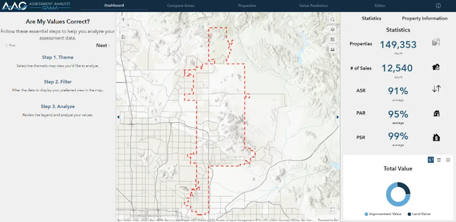
Esri Canada today announced the launch of Assessment Analyst ValueIT, a powerful visualization and analytic application that revolutionizes property assessment by providing clarity and control over the accuracy of assessment values. With AA ValueIT, assessors can confidently determine if assessments meet local or state standards by leveraging the full potential of computer-assisted mass appraisal (CAMA) ...
directionsmag.com

Satellogic And Quant Data & Analytics Announce 3-year Agreement

Satellogic Inc., a leader in sub-meter resolution Earth Observation data (“EO”) collection, announced today that it has signed an agreement with Quant Data & Analytics (“Quant”), a leading Saudi provider of Data & AI Products and Enterprise Solutions focused on the real estate and retail sectors. This strategic agreement leverages Satellogic’s high-resolution satellite imagery to ...
spaceref.com

제주도, 농수산업에 ‘위성·항공·드론’ 융합영상 활용한다

제주특별자치도는 ‘공간지능정보(Geo-AI) 융합 영상분석 행정서비스 구축’을 위한 사업자를 선정하고 본격적인 사업 추진에 앞서 지난 18일 착수보고회를 개최했다고 밝혔다. 착수보고회에는 공동주관기관인 한국국토정보공사와 한국항공우주연구원, 한국교통연구원 등에서 자문위원이 참석해 사업 방향을 논의했다. 도는 이번 사업을 통해 위성·항공, 드론 영상을 융합해 인공지능으로 처리하는 데이터 분석 플랫폼을 만들고 데이터 분석결과를 활용해 지능형 행정서비스를 구축할 방침이다. 분석결과가 적용되는 지능형 행정서비스 모델은 ...
agrinet.co.kr
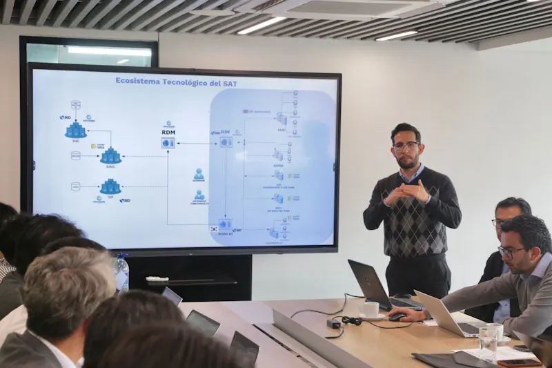
DNP Recibe Apoyo De Misión De Corea Del Sur Para Avanzar En La Implementación Del Sistema De Administración Del Territorio-SAT

DNP Recibe Apoyo De Misión De Corea Del Sur Para Avanzar En La Implementación Del Sistema De Administración Del Territorio-SAT

En el marco de la cooperación bilateral entre Colombia y Corea del Sur, se empezaron a definir las acciones que se desarrollarán conjuntamente para avanzar en la implementación del Sistema de Administración del Territorio-SAT, una de las principales apuestas planteadas en el Plan Nacional de Desarrollo 2022-2026,“Colombia, Potencia Mundial de la Vida”. El SAT es ...
areacucuta.com

Nowe Regulacje Usprawnią Standaryzację Zbiorów Danych Przestrzennych

Na stronach Rządowego Centrum Legislacji pojawił się projekt zmiany rozporządzenia Ministra Rozwoju i Technologii, który stawia ważny krok w kierunku standaryzacji tworzonych zbiorów danych przestrzennych. Zmiany dotyczącą dokładnie projektu regulacji zmieniających rozporządzenie w sprawie zbiorów danych przestrzennych oraz metadanych w zakresie zagospodarowania przestrzennego(1). Jego celem jest aktualizacja oraz rozszerzenie regulacji w zakresie tworzenia zbiorów obejmujących ...
teraz-srodowisko.pl

Govt To Undertake GIS Mapping Of Urban Areas

In order to plug revenue leakages, the state government will conduct a geographic information system (GIS) mapping of all properties in municipal areas in the state, Urban Development Minister Vishwajit Rane informed the Goa legislative assembly on Thursday. Rane said the work of GIS mapping has already started in North Goa and the tender process ...
navhindtimes.in

제주알마켓 하루방앱, ‘토지미래가치 예측기술’ 특허 등록

금일 제주알마켓 하루방앱은 ‘토지 미래가치 예측 기술’ 관련 특허 등록을 완료했다고 밝혔다. 이번에 특허받은 기술은 GIS(지리 정보 시스템)와 빅데이터 기술을 융복합한 토지의 미래가치 예측기능이 구비된 지도정보서비스시스템의 제어방법이다. 본 특허는 △개별토지의 환경적 및 사회적 가치 평가, △토지의 미래가치 예측 및 산출, △필지별 용도지역 분석, △용도지역 변경 이력 추적, △개발행위 허가 여부 판단, △개별공시지가 변동 추이 파악 ...
youthassembly.kr
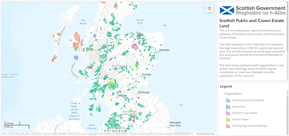
Tennessee Department Of General Services Launches New GIS Map To Display State-owned Land

Tennessee Department Of General Services Launches New GIS Map To Display State-owned Land

The Tennessee Department of General Services is pleased to announce the launch of the new State-Owned Land Dashboard, a Geographic Information System (GIS) public-facing map displaying all the land the state owns. The map gives users access to a comprehensive list of state-owned properties with numerous data points for each property, including address, District, State ...
clarksvilleonline.com