Geomaticians

ISRO

TRISHNA Mission

TRISHNA Mission: Advancing High-Resolution Thermal Imaging For Climate And Resource Management

The TRISHNA (Thermal Infra-Red Imaging Satellite for High-resolution Natural Resource Assessment) mission, a collaborative endeavor between ISRO and CNES, is engineered to deliver high spatial and high temporal resolution monitoring of Earth’s surface temperature, emissivity, biophysical and radiation variables for surface energy budgeting at regional to global scale. This mission addresses critical water and food ...
isro.gov.in

MoSPI Signs MoU With ISRO On Urban Frame Survey Using Bhuvan

The NSSO (FOD) under Ministry of Statistics and Programme Implementation (MoSPI) has entered into a Memorandum of Understanding (MoU) with the National Remote Sensing Centre (NRSC) under the Indian Space Research Organization (ISRO) to facilitate Urban Frame Survey (UFS) in a digital mode using the state-of-the-art Geo ICT tools and techniques using Bhuvan Platform. The ...
pib.gov.in

AWS Ties Up With ISRO And IN-SPACe To Advance India’s Space Capabilities With Cloud Technologies

Amazon Web Services (AWS) India Private Limited has signed a strategic Memorandum of Understanding with the Indian Space Research Organization (ISRO) and Indian National Space Promotion and Authorization Centre (IN-SPACe) to support space-tech innovations through cloud computing. This collaboration will give space startups, research institutes and students access to cutting edge cloud technologies that accelerate ...
aboutamazon.in
U.S. And India To Expand Spaceflight Cooperation

U.S. And India To Expand Spaceflight Cooperation

The governments of the United States and India have agreed to work more closely together in spaceflight, with India signing the Artemis Accords and the two countries planning for a joint mission of some kind to the International Space Station. In a fact sheet distributed by the White House, the governments said they agreed that ...
spacenews.com

ISRO To Launch New Navigation Satellite On May 29

Five years after launching the last navigation satellite in 2018, ISRO is gearing up to launch a new one on May 29 from Sriharikota to replace an old satellite. The aim is to maintain a constellation of functional seven satellites needed to keep its navigation system operational and running. Confirming the launch, a senior Isro ...
timesofindia.indiatimes.com

Scientists From Country’s Top Space Research Institutes Join Climate Change Deliberations At Kashmir University

Distinguished scientists from the country’s top research organisations involved in satellite earth observation including ISRO and other institutions of national importance joined deliberations on the use of satellite earth observation for climate services during a national-level workshop on ‘Earth Observations for Climate Services’ at the University of Kashmir on Thursday. Vice-Chancellor Prof Nilofer Khan inaugurated ...
greaterkashmir.com
ISRO To Launch Singapore’s EO Satellite

ISRO To Launch Singapore’s EO Satellite

The Indian Space Research Organisation (ISRO) will launch the Singaporean Earth Observation satellite TeLEOS-02 on Saturday, April 22. The launch will take place at 2.19 pm from the first launch pad at Sriharikota. The satellite on board will be TeLEOS 2—a 750kg earth observation satellite that has synthetic aperture radar capable of providing data in ...
geospatialworld.net

US Aerospace Firm Lockheed Martin Space Looking To Work With ISRO, Indian Pvt Space Sector

American defence-aerospace firm Lockheed Martin’s Space division has been in talks with the Indian Space Research Organisation (ISRO) and the emerging Indian private space sector for collaboration, said a top official. This is a result of India’s space sector being reformed to permit private firms to carry out end-to-end space activities and seek government support ...
wionews.com
ISRO Set To Lift-off New User-friendly Launch Vehicle Designed For Smaller Satellites

ISRO Set To Lift-off New User-friendly Launch Vehicle Designed For Smaller Satellites

Indian Space Research Organisation will be making its second attempt to launch the Small Satellite Launch Vehicle. This second development flight — SSLV-D2 — will be launched from Sriharikota tomorrow at 9.18 a.m. SSLV-D2 will inject three satellites, namely EOS-07, Janus-1 and AzaadiSAT-2 into a 450 kilometre circular orbit during its 15-minute flight. Among the ...
indianarrative.com

Policy To Make Adoption Of Indian Standard Time Mandatory On Anvil: Government Official

The government is planning to come out with a comprehensive policy for mandatory adoption of Indian Standard Time (IST) nationwide, a senior consumer affairs ministry official said. The purpose is to ensure synchronization of all networks and computers to IST and adoption of IST by Telecom Service Providers, Internet Service Providers, power grids, banks, stock ...
outlookindia.com
GIS Energy Map For Resource And Infra Planning

GIS Energy Map For Resource And Infra Planning

The Geospatial Energy Map of India by the NITI Aayog, in collaboration with ISRO, identifies and locates all primary and secondary sources of energy along with their transportation and transmission networks. The idea is to develop a web-GIS-based information system for the visualisation of spatial and non-spatial data associated with conventional energy sources in India ...
geospatialworld.net

ISRO To Develop “Spatial Data Infrastructure Geoportal ‘Geo-ladakh’ For Ut-ladakh”

Union Minister of State (Independent Charge) Science & Technology; Minister of State (Independent Charge) Earth Sciences; MoS PMO, Personnel, Public Grievances, Pensions, Atomic Energy and Space, Dr Jitendra Singh today informed that Government of UT – Ladakh has approached the Indian Institute of Remote Sensing (IIRS), a unit of Indian Space Research Organisation (ISRO) for ...
indiaeducationdiary.in

India’s Latest Earth Observation Satellite Starts Serving Images

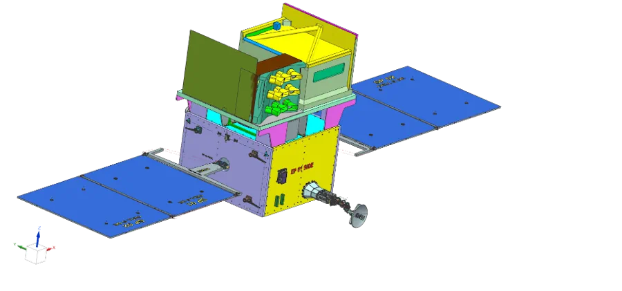
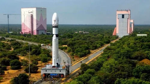
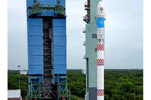
The Earth Observation Satellite-06 launched by the Indian Space Research Organisation on November 26 has started serving images, the national space agency said on Wednesday. Bengaluru-headquartered ISRO shared on Twitter the first-day images received on Tuesday at National Remote Sensing Centre, Shadnagar, Telangana, covering the Himalayan region, Kutch region of Gujarat and the Arabian Sea. ...
thehindu.com
Nagaland To Utilise Satellite Tech To Monitor Projects In Remote Areas

Nagaland To Utilise Satellite Tech To Monitor Projects In Remote Areas

The Nagaland government will utilise satellite technology in proper monitoring of projects in remote areas which are otherwise difficult to reach, due to the rough terrain of the state, officials said on Tuesday. Principal Secretary and Development Commissioner, Amardeep Singh Bhatia, addressing at a day-long workshop for nodal officers of line departments on the implementation ...
daijiworld.com

UIDAI-ISRO Portal To Locate Your Nearest Aadhaar Centre In Few Clicks

Today, a 12-digit unique number is facilitating mobility for millions of people who migrate from one part of the country to another, as it is a universal identity across India. The National Remote Sensing Centre (NRSC), one of the core centres of the Indian Agency – ISRO, have collaborated with the Unique Identification Authority of ...
newsonair.com