Geomaticians

Hydrology

Grundwassermangel Im Nordwesten So Knapp Ist Die Ressource

Grundwassermangel Im Nordwesten: So Knapp Ist Die Ressource

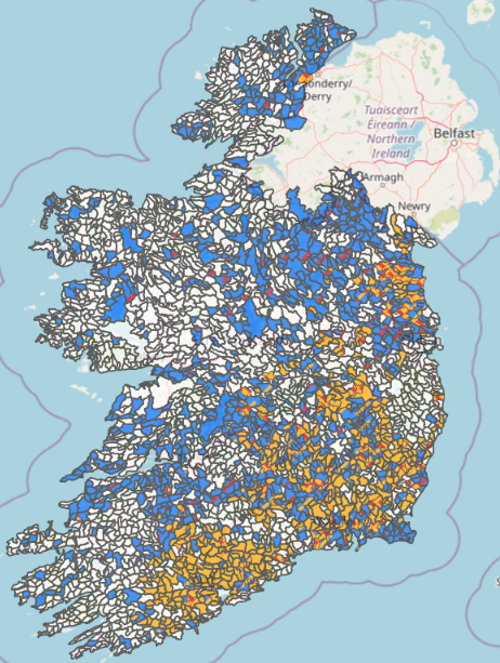
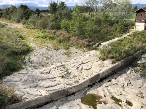
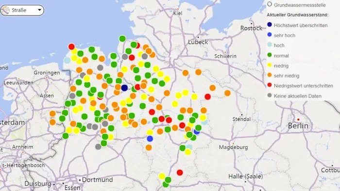
Der Nordwesten leidet wie weite Teile Deutschlands unter anhaltender Dürre. Das wirkt sich auch auf den Grundwasserspiegel aus. Wo genau, zeigt eine Karte. Herausgegeben wird die Karte, die stets tagesaktuelle Werte ausgebe, vom niedersächsischen Landesbetriebs für Wasserwirtschaft, Küsten- und Naturschutz, kurz NLWKN, teilte die Behörde mit. Da in Folge langanhaltender Dürre und immer wiederkehrender Trockenjahre ...
t-online.de

GeoHub: Nueva Aplicación Monitorea Riesgos Ambientales Y Ante Desastres En La Cuenca Del Río Maipo

El objetivo de esta plataforma, desarrollada por el Centro de Investigación para la Gestión Integrada del Riesgo de Desastres (CIGIDEN) y el Observatorio de la Costa, es transferir conocimiento científico relacionado con la gestión de cuencas y áreas litorales. La aplicación incorpora herramientas de captura, catalogación y visualización de datos geoespaciales. El trabajo es liderado ...
uc.cl

Índice Ambiental Municipal Pode Ser Acessado No Painel De Indicadores Do Sisema

Maior interatividade, agilidade e acessibilidade. Essas são as características que a consulta ao Índice de Desempenho Ambiental Municipal (Idam) passa a ter no Painel de Indicadores (Power Bi) do Sistema Estadual de Meio Ambiente e Recursos Hídricos (Sisema). A partir desta segunda-feira (26/6), é possível saber como está o desempenho ambiental das cidades de Minas, ...
agenciaminas.mg.gov
Using Geospatial Tools To Assess Sewer Risk

Using Geospatial Tools To Assess Sewer Risk

Anglian Water is the largest water and water recycling company by geographic area in England and Wales, serving much of the Eastern portion of the United Kingdom. Recently, the utility company created a geospatial tool in order to get a real-time picture of sewer risk and identify specific hotspots to prioritize where work is most ...
geoweeknews.com
New Salt Lake Program Uses Weather Data, Satellite Imagery To Help Residents Water More Efficiently

New Salt Lake Program Uses Weather Data, Satellite Imagery To Help Residents Water More Efficiently

Water supply in Utah’s capital city is in a good place after a robust snowpack runoff that’s all but over. As the irrigation season moves forward, Salt Lake City is turning to a new tool to help reduce overwatering in the summer. Salt Lake City officials announced a new pilot program with Utah State University ...
ksl.com
Global Water Reservoir Volumes Decline Despite Construction Boom, Study Says

Global Water Reservoir Volumes Decline Despite Construction Boom, Study Says

Water is an essential and indispensable component of humanity’s everyday existence. As the global population grows and the climate warms, so does the water demand. Over the past two decades, global reservoirs have become increasingly empty despite an overall increase in total storage capacity due to the construction of new reservoirs. Led by Dr. Huilin ...
today.tamu.edu
İSKİ, Yeni Coğrafi Bilgi Sistemi Altyapısı İSKABİS+ İle Tanıtıldı

İSKİ, Yeni Coğrafi Bilgi Sistemi Altyapısı İSKABİS+ İle Tanıtıldı

İstanbul Büyükşehir Belediyesi (İBB) kurumu İstanbul Su İşleri ve Kanalizasyon İdaresi (İSKİ), yeni Coğrafi Bilgi Sistemleri (CBS) altyapısı olan “İSKİ Altyapı Bilgi Sistemi”ni (İSKABİS+) tanıttı. İSKİ’nin İstanbul içme suyu, atık su-yağmur suyu altyapı ve üstyapı tesislerinin konumsal olarak sorgulandığı, çeşitli network analizleri ile modelleme çalışmalarının yapıldığı coğrafi bilgi sistemi uygulaması, “İSKİ Altyapı Bilgi Sistemi” yenilendi.
sondakika.com
El IRTA Desarrolla Una Web Predictiva Para La Demanda Hídrica De Lleida

El IRTA Desarrolla Una Web Predictiva Para La Demanda Hídrica De Lleida

En un contexto de cambio climático, las comunidades de regantes juegan un rol muy importante a la hora de gestionar y garantizar la disponibilidad del agua, tal y como se está viendo en la situación de extrema sequía actual. Por eso, es esencial que se modernicen y dispongan de herramientas para saber la demanda de ...
retema.es
کنفرانس ملی سیستم اطلاعات مکانی در صنعت آب و برق در واحد علوم و تحقیقات برگزار شد

کنفرانس ملی سیستم اطلاعات مکانی در صنعت آب و برق در واحد علوم و تحقیقات برگزار شد

هفتمین کنفرانس ملی سیستم اطلاعات مکانی (GIS)، به همت معاونت پژوهشی واحد علوم و تحقیقات، با همکاری وزارت نیرو و شرکت توزیع نیروی برق تهران بزرگ با هدف دستیابی به آخرین یافته‌های علمی و پژوهشیGIS در ایران و جهان و تبادل تجربیات حاصله در صنعت آب و برق کشور و با حضور جمعی از پژوهشگران، ...
iau.ir

인천 중·북부 상수도 시설,, 지리정보 시스템 갖춘다

인천시는 22일 북부, 중부의 총 133.56㎞에 달하는 상수도 시설물의 위치와 깊이 등 정보의 정확도를 높이기 위한 ‘2023년 상수도 지리정보시스템(GIS 정보 수정・갱신사업)’의 착수했다. 이번 사업은 기존에 단순 도면 전산화로 구축한 기존 상수관로 지리정보시스템(GIS) 정보를 위성통신을 활용해 상수시설물의 위치, 깊이, 관 재질 등 정보를 갱신하고 측정 정보 지리정보시스템(GIS)을 개선하는 사업이다. 부평정수장 탐사측량 시연회에서 전자유도탐사기·토탈스테이션 등의 장비를 동원해 ...
newsfreezone.co.kr
Deep Learning for the Earth Sciences

Deep Learning for the Earth Sciences: A Comprehensive Approach to Remote Sensing, Climate Science, and Geosciences

Deep learning is a fundamental technique in modern Artificial Intelligence and is being applied to disciplines across the scientific spectrum; earth science is no exception. Yet, the link between deep learning and Earth sciences has only recently entered academic curricula and thus has not yet proliferated. Deep Learning for the Earth Sciences delivers a unique ...
onlinelibrary.wiley.com

Tracasa Global Implantará El Sistema GIS Para Gestionar Las Redes De Agua En 11 Municipios De La Costa Del Sol

Tracasa Global, empresa pública del Gobierno de Navarra, implantará el sistema de información geográfica (GIS) para la gestión de redes de agua en Acosol, que da servicio a 11 municipios de la Costa del Sol, en la provincia de Málaga. La empresa navarra, que comenzará a introducir sus servicios GeoSAS -con la tecnología Utility Network ...
aguasresiduales.info

State Unveils Interactive Soil, Water Sampling Map

The Pennsylvania Department of Environmental Protection (DEP) on Tuesday released a new interactive mapping tool that shows final sample results from soil and water testing conducted by DEP in the wake of the Feb. 3 East Palestine train derailment. Pennsylvanians can use this tool to review sampling results in the vicinity of the derailment. The ...
latrobebulletinnews.com
How Much Do We Value Healthy Rivers And Streams

How Much Do We Value Healthy Rivers And Streams?

The economic benefit of water quality improvements depends on where those improvements occur. But which water quality changes do New England residents value the most, and where would they prefer these changes to occur across large river and stream networks? Robert J. Johnston, director of the George Perkins Marsh Institute and professor of economics, and ...
clarknow.clarku.edu
Sivas Belediyesi Su Kaçaklarını Yapay Zekalı Sistemle Tespit Edecek

Sivas Belediyesi Su Kaçaklarını Yapay Zekalı Sistemle Tespit Edecek

Yeni nesil teknoloji şirketi Cerebrum Tech, Sivas Belediyesi Su ve Kanalizasyon İşleri (Sibeski) Müdürlüğü ve Kore Çevresel Endüstri ve Teknoloji Enstitüsü (KEITI), su kaçaklarının yönetimi ve tespitinin sağlanması için birlikte çalışmaya başlıyor. 8 ay sürecek olan ‘Akıllı Su Kaybı Yönetimi Projesi’nde, iki Bölgesel Ölçüm Alanında (DMA) yaklaşık 5000 aboneyi kapsayan bir çalışma gerçekleştirilecek. DMA kontrolünü ...
yenigungazetesi.net
New Project Will Track Changes To Water, Ecosystems And Land Surface

New Project Will Track Changes To Water, Ecosystems And Land Surface

Scientists routinely rely on data-intensive analysis and visualization of satellite observations to track Earth’s ever-changing surface. A new project will make it possible for anyone with an internet connection to begin to answer these questions and more about changes to our dynamic planet. The OPERA (Observational Products for End-Users from Remote Sensing Analysis) project is ...
sciencex.com
Neural Networks Map The Ebb And Flow Of Tiny Ponds

Neural Networks Map The Ebb And Flow Of Tiny Ponds

Small ponds emit a surprisingly large amount of methane compared with larger water bodies. Because ponds are so tiny, they have been difficult to track, and their contributions to terrestrial greenhouse gas emissions are largely unaccounted for. In a new study, Mullen et al. used deep learning to construct a fine-grained map of ponds in ...
eos.org

Civil Engineers Use Public Satellite Images To Study Why The Jagersfontein Dam Failed

On 11 September 2022, a diamond mine waste storage facility, known as a tailings dam, failed in the town of Jagersfontein in the Free State province of South Africa. In the failure, one person was killed and multiple homes destroyed. Tailings are the finely ground leftovers that remain after valuable metals are removed from rock ...
sciencedaily.com
Deutschland Verlor In Den Letzten Zwei Jahrzehnten Durchschnittlich 760 Millionen Tonnen Wasser Pro Jahr

Deutschland Verlor In Den Letzten Zwei Jahrzehnten Durchschnittlich 760 Millionen Tonnen Wasser Pro Jahr

Die letzten fünf Jahre in Deutschland waren von massiven Sommerdürren geprägt. Sehr viel Wasser ging verloren. Nur: Wie hoch die Verluste genau waren und ob sich daraus ein Trend für die Zukunft ableiten lässt, sind nach wie vor offene Fragen. Ein Team des Deutschen GeoForschungsZentrums (GFZ) hat nun mit Kolleg:innen die Jahre 2002-2022 genauer untersucht. ...
idw-online.de
Córdoba Suma Tecnología A La Producción Agrícola

Córdoba Suma Tecnología A La Producción Agrícola

Con datos de la campaña 2021/22 que se suman a los existentes de 2020/21 y el relevamiento en marcha de la vigente campaña 2022/23, Córdoba consolida una nueva metodología de estimaciones agrícolas que incluye el mapeo de cultivos y estimación de rindes y producción a escala semi-predial. El nuevo modelo, desarrollado por el Ministerio de ...
Water-Tracking Satellite Reveals First Views

Water-Tracking Satellite Reveals First Views

The international Surface Water and Ocean Topography (SWOT) mission—led by NASA and the Centre National d’Études Spatiales (CNES)—has sent back some of its first glimpses of water on the planet’s surface, showing ocean currents like the Gulf Stream in unprecedented detail. The spatial resolution of SWOT ocean measurements is 10 times greater than the composite ...
earthobservatory.nasa.gov
How A Florida Water District Uses Google Tools For Quality Management

How A Florida Water District Uses Google Tools For Quality Management

The South Florida Water Management District oversees water resources for more than 9 million residents, from Orlando to the Florida Keys. That means monitoring water quality, especially in Lake Okeechobee, the largest freshwater lake in the state and the 10th largest lake in the country. That’s no small task. In partnership with Google Public Sector, ...
statetechmagazine.com

South West Water Interactive Map Created To Show Water Quality At Beaches

An interactive map has been created by South West Water showing sewage releases around the coast. The WaterFit Live map is designed to share information about the region’s bathing beaches, location and performance of storm overflows, as well as the company’s plans to improve water quality. The government is making it mandatory for all water ...
itv.com
National Geographic Society And Utrecht University Launch World Water Map

National Geographic Society And Utrecht University Launch World Water Map

The National Geographic Society launched the World Water Map as part of its five-year World Freshwater Initiative to better understand developing freshwater shortages around the world and inspire sustainable action. The Map was created by the National Geographic Society in cooperation with Utrecht University and Esri to identify water availability hotspots, visualize global freshwater supply ...
blog.nationalgeographic.org
Lakes Can Change How Glaciers Move

Lakes Can Change How Glaciers Move

At the feet of mountain glaciers, melting ice forms pools of water that can be trapped behind moraines. And with warming temperatures, these pools are surging in both size and number. In Alaska and northwestern Canada, 183 new lakes appeared between 1984 and 2019, covering 483 square kilometers (190 square miles). New research showed that ...
eos.org
Wasserknappheit In Iran Ist Hausgemacht

Wasserknappheit In Iran Ist Hausgemacht

Forschende des Deutschen GeoForschungsZentrums GFZ haben zusammen mit Kolleg:innen der Universität Stuttgart und des Karlsruher Instituts für Technologie KIT die Entwicklung der letzten zwanzig Jahre für den gesamten Iran nachgezeichnet. Die Studie erschien kürzlich in der Fachzeitschrift Scientific Reports. Das Team nutzte dafür ausschließlich global verfügbare Datensätze, u.a. MODIS-Satellitenzeitreihendaten, Daten der GRACE/-FO-Satellitenmissionen und ERA5-Reanalyse-Klimadaten. Für ...
gfz-potsdam.de
EPA Creates Water Quality Map Of Farm-related Pressure Areas

EPA Creates Water Quality Map Of Farm-related Pressure Areas

The Environmental Protection Agency (EPA) has developed a map which highlights how water quality is affected by farming activity in different areas of the country. The map, which was published this month, is divided into sub-basins, which are colour-coded to highlight different issues related to farming activity. A single sub-basin may be colour-coded with different ...
agriland.ie
Grazer Forscher Stellen Schwere Dürre In Europa Fes

Grazer Forscher Stellen Schwere Dürre In Europa Fest

Kernstück des EU-Projekts, von dem die TU Graz wesentlicher Bestandteil ist, sind Zwillingssatelliten namens “Tom und Jerry”. In einer polaren Umlaufbahn in knapp 490 Kilometern Höhe umkreisen die Satelliten die Erde und liefern den Geodätinnen und Geodäten der TU Graz dabei die Daten aus dem Weltall, die sie für die Bemessung des Grundwasserspeichers brauchen. Das ...
meinbezirk.at

Yeraltı Sularının Kullanılması Nedeniyle…

Gümüşhane Üniversitesi Rektörü Prof. Dr. Halil İbrahim Zeybek, Mühendislik ve Doğa Bilimleri Fakültesi Harita Mühendisliği Bölüm Başkanı Doç. Dr. Sefa Yalvaç ile Mühendislik ve Doğa Bilimleri Fakültesi Jeoloji Mühendisliği Bölümü Uygulamalı Jeoloji Kürsüsü Öğretim Üyesi Doç. Dr. Selçuk Alemdağ, zemin çökmelerinin güncel jeodezik tekniklerle izlenmesi ve olası nedenlerinin araştırılmasına yönelik bilimsel çalışma başlattı. Çalışmalar kapsamında ...
torbaliguncel.com