Geomaticians

Hexagon

Hexagon Releases Power Portfolio 2023

Hexagon’s Safety, Infrastructure & Geospatial division announced the launch of Power Portfolio 2023, the latest version of its leading GIS, remote sensing, photogrammetry and geospatial data management products. Power Portfolio 2023 brings the most extensive upgrade to ERDAS APOLLO in a decade. Now built on LuciadFusion, a scalable platform for geospatial data management and publication, ...
directionsmag.com

Hexagon Updates Puerto Rico And U.S. Virgin Islands Aerial Imagery And Elevation Mapping Data

Hexagon’s Geosystems division has updated high-resolution aerial data covering the entire Commonwealth of Puerto Rico and the U.S. Virgin Islands as part of the HxGN Content Program. Captured during the 2021-2023 flying seasons, the data set includes four-band, 6-inch resolution orthorectified imagery of Puerto Rico — except Isla Mona and Isla Desecheo, which are offered at 12-inch ...
gpsworld.com
Leica Geosystems Presents Hybrid Imaging And Lidar Sensor For Extensive Airborne Surveys

Leica Geosystems Presents Hybrid Imaging And Lidar Sensor For Extensive Airborne Surveys

Leica Geosystems, a part of Hexagon, has launched the brand-new Leica CountryMapper, its most efficient solution yet for large-area imaging and Lidar mapping. The company unveiled this latest expansion to its hybrid sensor portfolio during the annual HxGN Live event. By integrating a large-format photogrammetric camera and a high-performance Lidar unit into a single system, ...
gim-international.com
Hexagon US Federal Announces The Digital Defense Summit At HxGN Live Global 2023

Hexagon US Federal Announces The Digital Defense Summit At HxGN Live Global 2023

Hexagon US Federal is involved in shaping a first-of-its kind Digital Defense Summit for U.S. Government and global attendees from federal civilian, defense, intelligence organizations, and industry partners and customers. The four-day event will take place during the HxGN Live Global 2023 digital reality conference, from June 12 – 15, 2023 in Las Vegas, NV.
businesswire.com
Hexagon Announces New Platform For Defense Mobile App

Hexagon Announces New Platform For Defense Mobile Apps

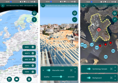
Hexagon’s Safety, Infrastructure & Geospatial division has introduced LuciadCPillar for Android, a platform for developing mobile applications for dismounted soldiers in the field. The new Android platform enables developers to build applications with 2D/3D views, featuring military symbology and supporting many geospatial data types, including vector data, raster data, elevation data, point clouds and 3D ...
directionsmag.com

Hexagon And OSASI Technos Partner To Develop Disaster Management And Prediction Solutions

Hexagon’s Safety, Infrastructure & Geospatial division and OSASI Technos Inc. have announced a partnership to deliver next-generation disaster management and monitoring solutions. Using 3D visualization capabilities, governments will be able detect, predict and simulate impending disasters, enabling them to better plan for and respond to impending disasters, enabling them to better plan for and respond ...
geospatialworld.net

Hexagon And Fujitsu Support Stuttgart Urban Digital Twin Project

Hexagon’s Safety, Infrastructure & Geospatial division and Fujitsu Limited have partnered to deliver a digital twin platform for Stuttgart, Germany, to support the city’s urban digital twin project. The Civil Engineering Office will use the SaaS solution to visualize and analyse data from IoT sensors across the city to promote sustainability and enhance quality of ...
gim-international.com

Leica Geosystems Announces New Leica DMC-4 Airborne Imaging Sensor Delivering Superior Image Fidelity

Leica Geosystems, part of Hexagon, today announced the introduction of the Leica DMC-4, a highly efficient airborne imaging sensor providing unsurpassed image quality for various applications and complex mapping environments. The new system continues Leica Geosystems’ tradition of combining industry-leading optics with precision mechanics to deliver the highest mapping performance. The sensor provides superior image ...
directionsmag.com

Hexagon Announces Aerial Data Collection Of Eight US States

Hexagon’s Geosystems division announced today that the HxGN Content Program will refresh data for eight U.S. states during this year’s collection season. All states — California, New York, Pennsylvania, Oregon, Kentucky, Michigan, North Carolina, and West Virginia — will be updated at a 6-inch (15-centimeter) resolution statewide, marking the program’s shift from a 12-inch to ...
geospatialworld.net