Geomaticians

Health

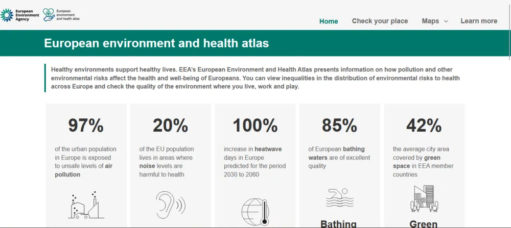
European Environment And Health Atlas Goes Live

European Environment And Health Atlas Goes Live

The interactive online tool, a first on such a scale for all of Europe, allows users to visualise how the environment around them affects their health and well-being via set of detailed maps. It covers topics like air quality, noise and quietness, green and blue spaces and climate change throughout the member and collaborating countries ...
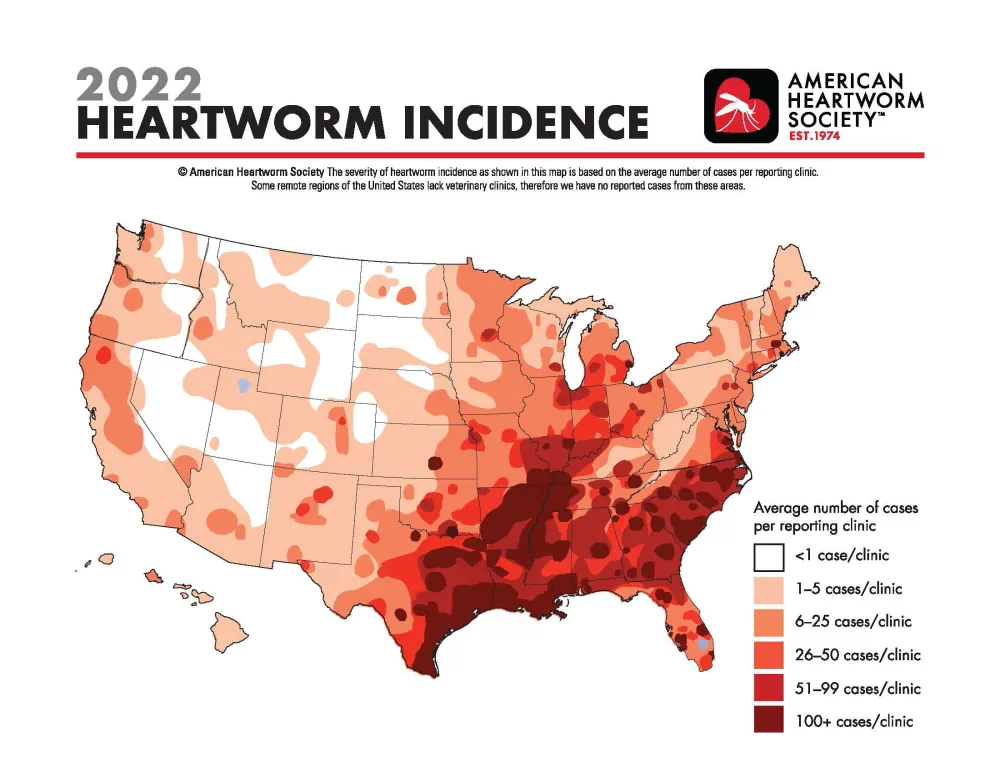
Map Shows Heartworm Rates Continue To Increase In Hot Spots, New Locations

Map Shows Heartworm Rates Continue To Increase In Hot Spots, New Locations

Incidence of heartworm disease has continued to rise not only in previously known hot spots but also in unexpected locations with previously low heartworm rates, according to the 2022 Heartworm Incidence Map from the American Heartworm Society (AHS). “For many pet owners—and even veterinarians—it can be all too easy to assume that heartworm isn’t common ...
avma.org
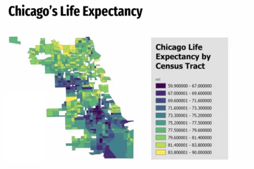
Mapping And Health Equity Project Created By UIC Alum, Student Addresses Chicago’s Health Disparities

Mapping And Health Equity Project Created By UIC Alum, Student Addresses Chicago’s Health Disparities

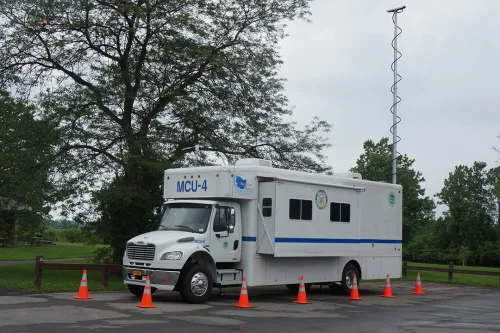
Near the end of the 2019 fall semester, Sonya Gupta was a University of Illinois Chicago undergraduate conducting research on the location and extent of healthcare deserts in the Chicago area and the potential of mobile health clinics to bridge the gap … In the fall of 2020, biological sciences major Ryan Zomorrodi started research ...
today.uic.edu

AIIMS To Launch India-made Real-time Navigation System

All India Institute of Medical Sciences (AIIMS), New Delhi, to launch an internal navigation system to help patients and their caregivers with accurate location. To help it materialise as soon as possible, a five-member team has been formed by Dr M Srinivas, Director, AIIMS. The team, headed by Dr Vivek Tandon from the neurosurgery department, ...
newindian.in
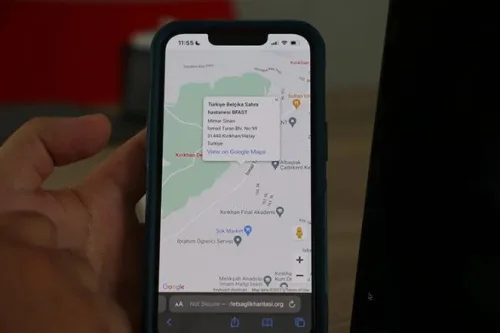
Afet Sağlık Haritası Hizmete Girdi

Afet Sağlık Haritası Hizmete Girdi

MEDAK, Kahramanmaraş merkezli depremlerin etkilediği illerde sağlık kuruluşları hakkında sahadaki insanların doğru ve güncel olarak bilgilendirilmesi için çalışma başlattı. Bu kapsamda dernek, deprem bölgesinde görev alan tüm yabancılar da dahil resmi ve özel yardım yardım kuruluşlarıyla temasa geçerek, gerek kendi görevlileri gerekse diğer kurumların yetkili kişileri tarafından illerde hizmet veren sabit veya gezici tüm sağlık ...
yenicaggazetesi.com.tr

Calgary Researcher Hoping To Drive Change For People With Dementia

“Physicians usually use a cognitive assessment, with pen and paper usually, to determine whether a driver is fit to drive. But these assessments are very limited,” said Dr. Sayeh Bayat, an assistant professor in both the University of Calgary’s department of biomedical engineering and geomatics engineering at the Schulich School of Engineering. Bayat recently received ...
globalnews.ca

South West Water Interactive Map Created To Show Water Quality At Beaches

An interactive map has been created by South West Water showing sewage releases around the coast. The WaterFit Live map is designed to share information about the region’s bathing beaches, location and performance of storm overflows, as well as the company’s plans to improve water quality. The government is making it mandatory for all water ...
itv.com

Esri GIS Helps Identify Gaps In Mental Health Service Provision

The Association of Mental Health Providers (AMHP) has created the first ever complete picture of mental health service provision across England, via a freely available interactive map, working in partnership with Esri UK. By combining data from the AMHP’s members and other mental health service providers, alongside demographic data, the map helps users understand where ...
directionsmag.com
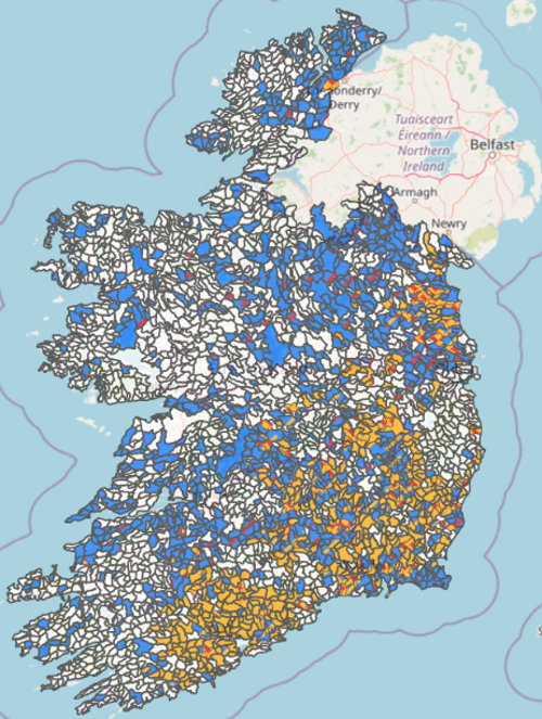
EPA Creates Water Quality Map Of Farm-related Pressure Areas

EPA Creates Water Quality Map Of Farm-related Pressure Areas

The Environmental Protection Agency (EPA) has developed a map which highlights how water quality is affected by farming activity in different areas of the country. The map, which was published this month, is divided into sub-basins, which are colour-coded to highlight different issues related to farming activity. A single sub-basin may be colour-coded with different ...
agriland.ie
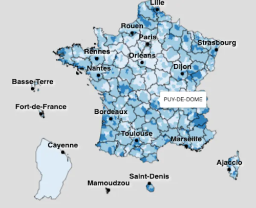
Identifier Les Déserts Médicaux La Question Sous-estimée De L’accès Des Patients Aux Soins

Identifier Les Déserts Médicaux : La Question Sous-estimée De L’accès Des Patients Aux Soins

En France, l’accessibilité aux soins et les difficultés qu’elle présente pour les citoyens sont tous les jours un peu plus au centre du débat public … Les principales mesures des difficultés d’accès aux soins utilisées en France reposent essentiellement sur des indicateurs de densité médicale et de temps d’accès au professionnel de santé le plus ...
theconversation.com
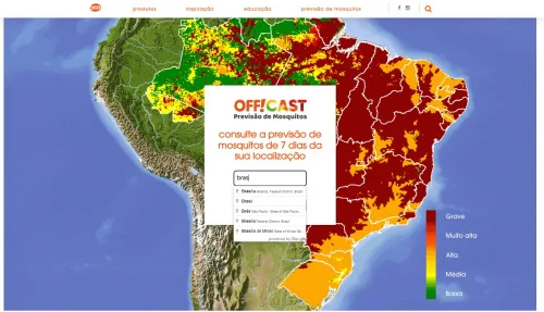
Google Lança Plataforma Que Prevê A Proliferação De Mosquitos Por Região Do País

Google Lança Plataforma Que Prevê A Proliferação De Mosquitos Por Região Do País

A plataforma “OFF!Cast Previsão de Mosquitos” já está no ar e mostra quais as chances de uma região no país ter maior ou menor presença de mosquitos. A ideia é prevenir a proliferação desses vetores, que trazem doenças como dengue, febre amarela, zika, malária e chikungunya. A OFF!Cast Previsão de Mosquitos é resultado de uma ...
olhardigital.com.br

Ankara Üniversitesi Türkiye’nin “Nadir Hastalık” Haritasını Çıkaracak

Ankara Üniversitesi (AÜ) bünyesinde, nadir hastalıklara yönelik ilaç, tanı kiti ve takipte kullanılabilecek yenilikçi yöntemler geliştirilmesi, biyobanka, hastalıklar açısından coğrafi haritanın oluşturulması ve tedavi modellerinin tanımlanması için Nadir Hastalıklar Uygulama ve Araştırma Merkezi kuruldu. Merkezin başkanı ve AÜ Tıp Fakültesi Öğretim Üyesi Prof. Dr. Fatma Tuba Eminoğlu, AA muhabirine yaptığı açıklamada, nadir hastalıkların 2 binde ...
aa.com.tr
NGIS And Google Earth Engine Work On Digital Twin

NGIS has collaborated with a range of organisations on the Australian Environmental Health (AusEnHealth) Strategic Planning Digital Twin project. The project aims to understand the landscape of environmental health data collection around the country. By 2030, the direct damage of costs to health is expected to be between $3 billion and $6 billion per year, ...
spatialsource.com.au

Rutgers Researcher Creates Algorithms To Predict Arsenic Contamination In Private Wells In New Jersey

“New Jersey has many naturally occurring arsenic sources, which can elevate the arsenic concentration in groundwater,” said Subhasis Giri, an assistant research professor in the Department of Ecology, Evolution and Natural Resources and lead author of the study published in the journal Science of the Total Environment. “Our work contributes to the understanding of this ...
newswise.com
Pesquisa Mostra Que Poluição Pode Impactar No Desempenho Escolar Dos Estudantes

Pesquisa Mostra Que Poluição Pode Impactar No Desempenho Escolar Dos Estudantes

Não é novidade que impactos negativos no meio ambiente são capazes de gerar inúmeras consequências para o mundo e para a sociedade. No entanto, para além das mudanças climáticas, e os riscos econômicos ocasionados pela poluição, pesquisadores da Escola de Políticas Públicas e Governo da Fundação Getulio Vargas (FGV EPPG), em Brasília, investigam o impacto ...
portal.fgv.br
New EWG Research Finds Many North Carolina Factory Farms Are At Risk Of Flooding

New EWG Research Finds Many North Carolina Factory Farms Are At Risk Of Flooding

A new Environmental Working Group geospatial analysis finds over 2 percent of North Carolina’s 7,352 swine and poultry factory farms are in or just outside floodplains. When these farms flood, they can contaminate water with bacteria and other health hazards. “The 156 factory farms we found in and near North Carolina’s floodplains are at a ...
ewg.org
RIT Researchers Explore How To Improve Emergency Management For The Deaf Community

RIT Researchers Explore How To Improve Emergency Management For The Deaf Community

At Rochester Institute of Technology and the National Technical Institute for the Deaf, a team of researchers is studying how to identify and bridge gaps in emergency management resources and services for the Deaf and Hard-of-Hearing community. Supported by a grant from the National Science Foundation Civic Innovation Challenge, the project is bringing together academic ...
rit.edu

Navigating Urban Spaces: Indoor And Outdoor Wayfinding Technology For Vision-impaired People

Navigating an unfamiliar place is uniquely challenging for people with disabilities. People with blindness, deafblindness, visual impairment or low vision, as well as those who use wheelchairs, can travel more independently in urban areas with the aid of effective wayfinding technology. A new report from the National Institute for Transportation and Communities (NITC) explores how ...
sciencedaily.com
High-Tech Map Promotes Access To Medicine And Pharmacy Services

High-Tech Map Promotes Access To Medicine And Pharmacy Services

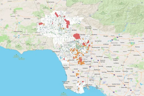
USC’s Dima M. Qato spent more than a decade working as a community pharmacist and public health advocate in underserved refugee and immigrant communities in Chicago. Through her experiences and public health training, Qato — the daughter of a pharmacist and now an associate professor at the USC School of Pharmacy — has come to ...
news.usc.edu

Study Finds Neighborhood Features Impact Mental And Physical Health For Better Or Worse

Sidewalks, single-lane roads and street signs could all be part of the path to a community’s mental and physical health, for better or worse, according to a new University of Maryland-led study. The research analyzed Google Street View images of diverse regions of the United States to correlate elements of the built environment to health ...
today.umd.edu

Likelihood Of Receiving An Autism Diagnosis May Depend On Where You Live

New autism diagnoses tend to be clustered within specific NHS service regions, suggesting that where an individual lives may influence whether they receive an autism diagnosis and access to special education needs support. The latest findings, from researchers from the University of Cambridge in collaboration with researchers from the London School of Economics and Political ...
cam.ac.uk
Try It Map Rates How Well Your Neighborhood Protects Cognition

Try It: Map Rates How Well Your Neighborhood Protects Cognition

Access to civic and social organizations, cultural centers such as museums and art galleries, and recreation centers may help protect against cognitive decline as a person ages, a new study suggests. A new interactive map allows you to plug in your address and assess how your neighborhood could support healthy cognitive aging, a theory the ...
futurity.org
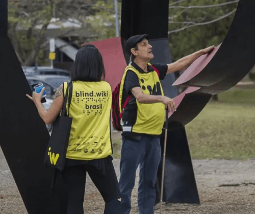
Aplicativo Cria Mapa Sensorial De Obras De Arte Para Pessoas Com Deficiência Visual

Aplicativo Cria Mapa Sensorial De Obras De Arte Para Pessoas Com Deficiência Visual

Pensando em dar voz a pessoas com algum tipo de deficiência visual e sensibilizar a sociedade sobre sua complexa relação com o espaço público urbano, a plataforma BlindWiki, criada pelo artista espanhol Antoni Abad, chega ao Brasil para gerar novas experiências a esse público. No jardim de esculturas do MAM, no Memorial da América Latina ...
casavogue.globo.com

Researchers Examine Link Between Pesticides And Thyroid Cancer Risk In Central California Area

The authors say this study provides the first evidence supporting the hypothesis that residential pesticide exposure from agricultural use is associated with an increased risk of thyroid cancer. The authors performed a case-controlled study using thyroid cancer cases from the California Cancer Registry (1999-2012) and controls sampled in a population-based manner. Study participants were diagnosed ...
eurekalert.org

Bringing Children Closer To Nature Helps Improve Their Lung Health

Getting children closer to green spaces as they grow up could improve their lung health, according to a study published today (Wednesday) in the European Respiratory Journal. The research found that children tended to have better lung function if their exposure to vegetation close to their homes increased in the first ten years of life. ...
eurekalert.org

Social Determinants Of Health Associated With Asthma Morbidity In Children

Study results published in Pediatrics showed that adverse social determinants of health (SDOH) were significantly associated with increased at-risk rates (ARRs) of pediatric asthma morbidity and that these ARRs varied widely across census tracts in Washington, DC. Researchers aimed to evaluate the associations between pediatric asthma morbidity and SDOH in the different census tracts using ...
ajmc.com

Researchers Identify Higher Rates Of Young-onset CRC Mortality In Midwest, Great Lakes Regions

Using CRC-specific mortality data from 3,036 U.S. counties from 1999 to 2019, researchers at the Lerner Research Institute and the Center for Young-Onset Colorectal Cancer at Cleveland Clinic categorized patients by age at diagnosis and adjusted for young-onset CRC risk factors and prognostic indicators. They identified new young-onset CRC mortality hot spots in the Midwest ...
healio.com

Detectan Influencias Ambientales En La Distribución De Parasitosis Intestinales

Investigadores de la Universidad Nacional de La Plata (UNLP) detectaron la influencia del medio ambiente en la distribución de parasitosis intestinales y estimaron que un calentamiento global hará proliferar esa enfermedad y su dispersión. Para el estudio utilizan el Sistema de Información Geográfica y sensores remotos que les permiten monitorear a distancia el riesgo de ...
grupolaprovincia.com
New Study Pegs Yellow Fever Mosquito’s Average Flight Range at 106 Meters

New Study Pegs Yellow Fever Mosquito’s Average Flight Range at 106 Meters

Because the yellow fever mosquito is the primary vector of human diseases like yellow fever, dengue, chikungunya, and Zika, figuring out how far the mosquito usually travels is an important data point for managing it. In a meta-analysis published May 31 in the Journal of Medical Entomology, researchers from the University of Arizona determined an ...
entomologytoday.org