Geomaticians

Health

Singapore Releases 10-Year Geospatial Master Plan

Singapore has launched its new Geospatial Master Plan (2024–33), the second iteration of the island state’s 10-year geospatial strategy. Led by the Singapore Land Authority (SLA) and the Maritime and Port Authority of Singapore (MPA), the Master Plan aims to “enable geospatial-enabled innovations to benefit more segments of society, while addressing the complex challenges Singapore ...
spatialsource.com.au

In A First, Japan Doctors Sue Google Over Negative Reviews On Firm’s Map App

A group of 63 doctors filed a lawsuit with the Tokyo District Court on Thursday against Google seeking ¥1.45 million (about $9,400) in compensation for causing harm to their businesses through what they described as one-sided, hateful reviews for their clinics on Google Maps. The suit is the first in Japan — and possibly the ...
japantimes.co.jp
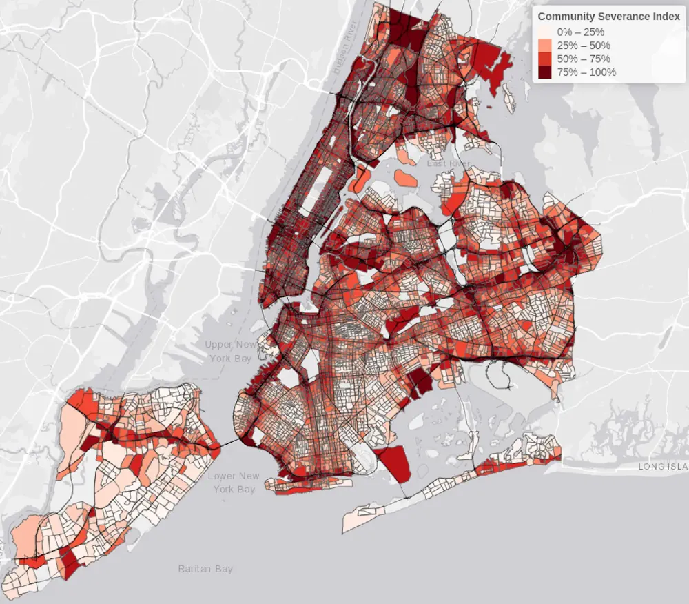
Communities Severed By Roads And Traffic Experience A Larger Number Of Collisions In New York City

Communities Severed By Roads And Traffic Experience A Larger Number Of Collisions In New York City

New York City neighborhoods with disrupted community connections, due to traffic, roads, and transport infrastructure, are experiencing an increase in traffic collisions. This increase is seen both in total collisions and for those in which pedestrians or cyclists are injured or killed, according to a new study from Columbia University Mailman School of Public Health. ...
phys.org

Poor Spatial Navigation Could Predict Alzheimer’s Disease Years Before The Onset Of Symptoms

People at risk of Alzheimer’s disease have impaired spatial navigation prior to problems with other cognitive functions, including memory, finds a new study led by UCL researchers. The research, published in Alzheimer’s & Dementia, used virtual reality to test the spatial navigation of 100 asymptomatic midlife adults, aged 43-66, from the PREVENT-Dementia prospective cohort study. ...
medicalxpress.com

Le Deep Learning Et La Cartographie Pour Établir Des Liens Entre Exposition Aux Pesticides Et Cancer

Présomption forte de lien entre exposition aux pesticides et six pathologies, dont plusieurs cancers et la maladie de Parkinson. C’est ce que confirme le rapport de l’Inserm (Institut national de la santé et de la recherche médicale) de 2021, en s’appuyant sur plusieurs études épidémiologiques récentes. Et cette conclusion concerne autant les professionnels du monde ...
cio-online.com
Students Analyze How U.S. Could Support Allies During Health Emergencies

Students Analyze How U.S. Could Support Allies During Health Emergencies

What if there were a public health crisis facing a U.S. ally? And what if the U.S. and other governments and international organizations were called on to offer humanitarian support? At Harvard T.H. Chan School of Public Health, three students with decades of experience in fields including data science, population health, and national security tackled ...
hsph.harvard.edu

Seniors Living Near Urban Open Spaces Report Less Mental Distress, A Dementia Risk Factor

With widening research, doctors have even more reasons to tell patients to spend time in open spaces for better mental health. Now, a statewide study suggests even small differences in nearness to urban green spaces and access to waterfronts have ties to improved self-reported mental health among people 65 and older. Such proximity to open ...
spokesman.com

Les Enfants Des Campagnes Ont Les Os Plus Solides Que Les Enfants Des Villes

Tout au long de leur croissance, et jusqu’à l’âge adulte, les enfants construisent leur capital osseux à l’aide de plusieurs apports : la génétique certes, mais aussi une bonne alimentation et un cadre de vie adapté. Mais selon une nouvelle étude menée sur de petits belges, le fait de profiter d’un environnement vert et d’être ...
doctissimo.fr
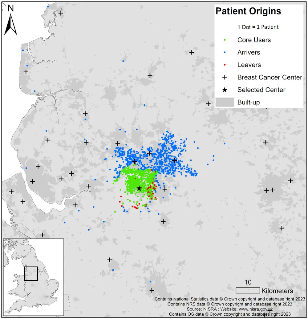
Many Women Bypass Nearest Hospital for Breast Cancer Surgery

Many Women Bypass Nearest Hospital for Breast Cancer Surgery

Many women undergoing breast-conserving surgery (BCS) or mastectomy bypass their nearest hospitals, according to a study published online Jan. 8 in Cancer. Ajay Aggarwal, M.D., Ph.D., from the London School of Hygiene and Tropical Medicine, and colleagues used linked administrative datasets from the English National Health Service to identify all women who underwent BCS or ...
healthday.com

Portal To Map Health Facilities Launched

The Department of Health Services (DoHS), on Wednesday launched the Geo Web Portal for Health Centres. Dr. HC Lyndem, the Director of DHS(MI), inaugurated the portal at the DHS headquarters in Shillong. The portal provides rich information through space technology mapping. It plays a crucial role in assessing existing health resources by considering factors such ...
themeghalayan.com
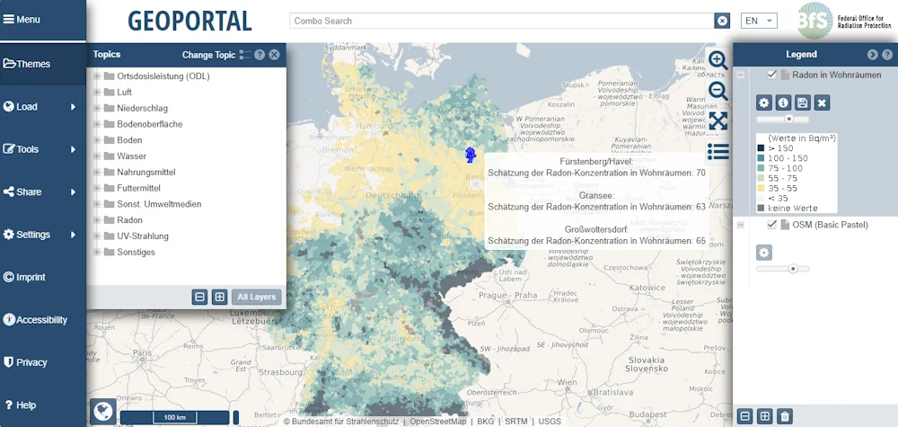
Neue Karte Zeigt Radon-situation In Wohnungen

Neue Karte Zeigt Radon-situation In Wohnungen

Man kann es weder sehen noch riechen oder schmecken: das radioaktive Gas Radon. In geringen Mengen ist es in jedem Gebäude vorhanden. Erhöhte Radon-Werte stellen ein ernst zu nehmendes Gesundheitsrisiko dar, denn dieser Innenraumschadstoff gehört – nach dem Rauchen – zu den häufigsten Ursachen von Lungenkrebs. Eine neue Karte des Bundesamtes für Strahlenschutz zeigt die ...
pro-physik.de
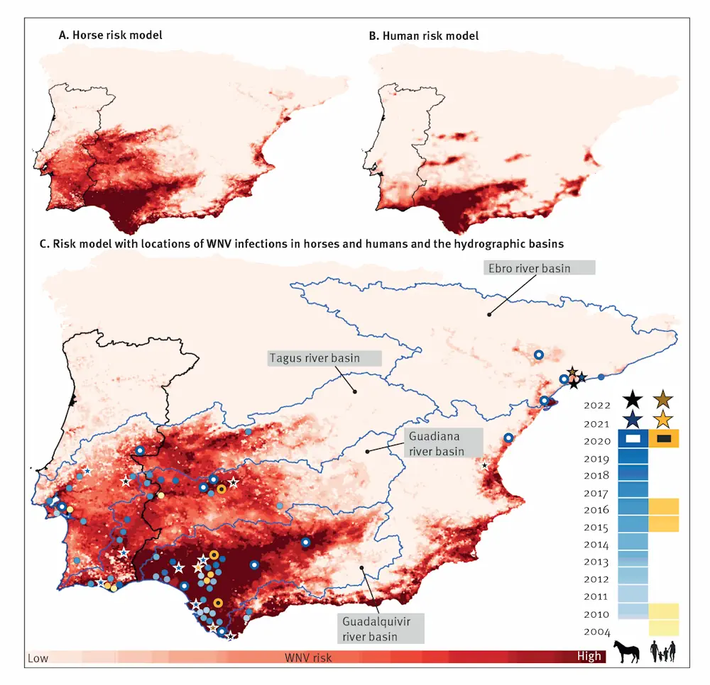
Elaboran Mapas Que Predicen El Riesgo De Contraer La Fiebre Del Nilo Occidental

Elaboran Mapas Que Predicen El Riesgo De Contraer La Fiebre Del Nilo Occidental

Científicos de la Universidad de Málaga evidencian que los caballos son buenos indicadores para anticipar su aparición en humanos. Se trata de un patógeno emergente en España que se transmite de aves a personas a través de las picaduras de mosquitos. El virus del Nilo Occidental es un patógeno emergente en España que se transmite ...
agenciasinc.es

Dorset Council Applies GIS To Optimising Home Care

Dorset Council has highlighted the role of interactive digital maps in a successful trial of an approach to optimise home care around the county. It has used the maps in a pilot project in which it worked with the Dorset Care Association, Home Care Forum and providers to reduce the average waiting time for a ...
ukauthority.com
Geospatial Analysis Identifies Areas With Individuals Eligible For Lung Cancer Screening

Geospatial Analysis Identifies Areas With Individuals Eligible For Lung Cancer Screening

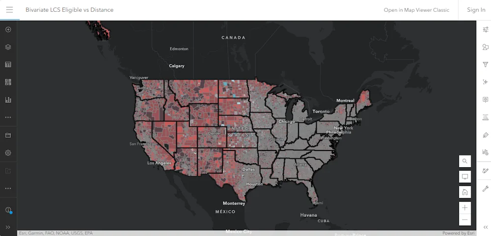
A model that incorporates demographic and smoking history data has identified regions populated with individuals eligible for lung cancer screening, according to study results presented at the CHEST annual meeting. “Geospatial techniques allow us to look at population-level trends as part of identifying next steps in lung cancer screening outreach and resource planning,” Christine Lambert, ...
healio.com
HHS Launches Climate And Health Outlook Portal To Identify Counties At Risk Of Climate-related Hazards

HHS Launches Climate And Health Outlook Portal To Identify Counties At Risk Of Climate-related Hazards

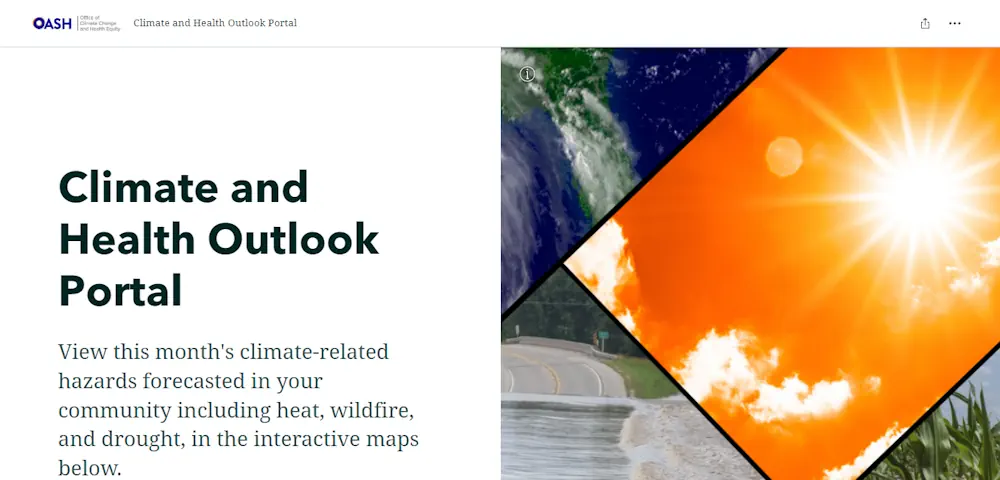
Today, in coordination with the White House Summit on Building Climate Resilient Communities, the U.S. Department of Health and Human Services’ (HHS) Office of Climate Change and Health Equity (OCCHE) and Administration for Strategic Preparedness and Response’s (ASPR) Geospatial Team launched the Climate and Health Outlook Portal , an interactive tool that provides actionable, county-level ...
hhs.gov
Guelph Study Aims To Improve Access To Public Washrooms

Guelph Study Aims To Improve Access To Public Washrooms

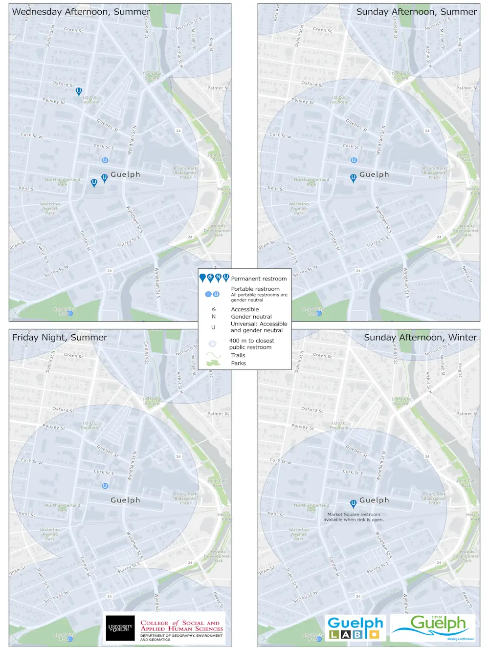
The Guelph Lab, a collaboration of The College of Social and Applied Human Sciences, University of Guelph and the City of Guelph, is working with the university’s Department of Geography, Environment and Geomatics to identify areas in the city without public washroom access so that facilities can be considered for the future. Guelph Lab facilitator ...
guelphtoday.com
Desarrollan Una Plataforma Con Información Espacial Para La Vigilancia De Enfermedades

Desarrollan Una Plataforma Con Información Espacial Para La Vigilancia De Enfermedades

La Comisión Nacional de Actividades Espaciales (CONAE) finalizó el desarrollo de un sistema integrado de vigilancia basado en información espacial para enfermedades transmitidas por vectores, que próximamente estará online para el uso del público en general, gobiernos locales e instituciones de la salud pública. La herramienta fue desarrollada completamente con software libre y de código ...
argentina.gob.ar

Le Géoportail De Santé Publique : Un Allié Pour Les Interventions En Santé

Le Géoportail de santé publique du Québec est une plateforme cartographique qui permet de visualiser la variation géographique d’indicateurs de santé et de ses déterminants partout au Québec. La plateforme est accessible à tous les organismes ainsi qu’au grand public. Des indicateurs sont aussi disponibles en lien avec la qualité de l’air et bruit environnemental, ...
cdeacf.ca

Sask. Project Aims To Reduce Drug Overdose Deaths

Ninety-two confirmed overdose deaths and 199 more suspected deaths have occurred in the province this year as of Aug. 1, according to a report from Saskatchewan’s Coroner. Now, a new project between the University of Regina and AIDS Programs South Saskatchewan (APSS), called Project Reportneedles.ca, was launched on Wednesday, which will aim to change those ...
regina.ctvnews.ca

Study Shows Green Space-Bipolar Correlation

Settlements with more green spaces have a lower rate of bipolar disorder, a Taiwanese research team found. The researchers of the study shared the results yesterday at a press conference held by the Science Media Center Taiwan. The research team, using satellite remote sensing, machine learning and data analysis, found a significant negative association between ...
taipeitimes.com
NYC Introduces Rat Info Portal Featuring Map And Inspection Histories By Property

NYC Introduces Rat Info Portal Featuring Map And Inspection Histories By Property

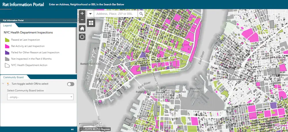
NYC Sanitation Commissioner Jessica Tisch famously said in 2022 that “the rats don’t run this city, we do” — but a newly launched map showing rodent-related violations shows it may be closer to a 50/50 split. The color-coded and searchable map was introduced Tuesday. It breaks down at a building-by-building level what places passed their ...
nbcnewyork.com
Where To Go SDSU Student Identifies Transit Line Needs

Where To Go? SDSU Student Identifies Transit Line Needs

An interdisciplinary team from San Diego State University analyzed the accessibility of public restrooms along transit lines countywide and found a shortage of facilities, particularly in the busiest stations, and a lack of important features in existing restrooms. Their project, “Where Can You Go On the Go?” was an initiative of SDSU’s Project for Sanitation ...
newscenter.sdsu.edu

UAH Researchers Team With Mental Health Nonprofit To Pioneer Use Of Artificial Intelligence To Improve Access To Care In North Alabama

Researchers at The University of Alabama in Huntsville (UAH) are teaming up with a local organization to pioneer the use of artificial intelligence (AI) to enhance the lives of autistic and neurodiverse individuals in North Alabama. The project is being funded by Little Orange Fish (LOF), a Huntsville, Ala., non-profit, to improve access to mental ...
uah.edu
Researchers Use Geospatial Mapping To Assist Burn Patients

Researchers Use Geospatial Mapping To Assist Burn Patients

University of Texas at Dallas researchers are using geospatial mapping techniques to identify social and environmental obstacles in communities that might impede burn injury survivors’ reentry into society. The project is designed to help patients with burn injuries better adapt to their lives after medical discharge, including improving patient access to transportation, employment, food and ...
news.utdallas.edu

New Study Finds Gaps In Maternal Immunization Data Sets

A study led by a University of Canterbury geospatial and population health expert has uncovered gaps in nationwide data that tracks maternal immunization rates. The study has been published in the New Zealand Medical Journal. Health Senior Lecturer Dr. Matt Hobbs is also co-director of the GeoHealth Laboratory in the University of Canterbury (UC) Geospatial ...
medicalxpress.com

Geo-Tracking System Enhances Polio Response In Congo

Since the Republic of Congo first confirmed a case of circulating variant poliovirus type 1 in March 2023 – the first such detection in more than two decades -, the country has been pioneering the deployment of Geospatial Tracking Systems (GTS) to help curb further transmission. Geospatial Tracking Systems have a critical role to play ...
afro.who.int

Tracasa Desarrolla Para Europa Una Aplicación Que Mide La Calidad Del Aire O El Ruido

La empresa pública navarra Tracasa Global ha desarrollado para la Agencia Europea de Medioambiente la aplicación Atlas Europeo de Medioambiente y Salud, con la que cualquier persona puede consultar la calidad del aire, el nivel de ruido o el número de espacios verdes, entre otros aspectos, en cualquier zona del continente. Esta herramienta interactiva, la ...
diariodenavarra.es
How Satellite Imagery Helps In The Fight Against Malaria

How Satellite Imagery Helps In The Fight Against Malaria

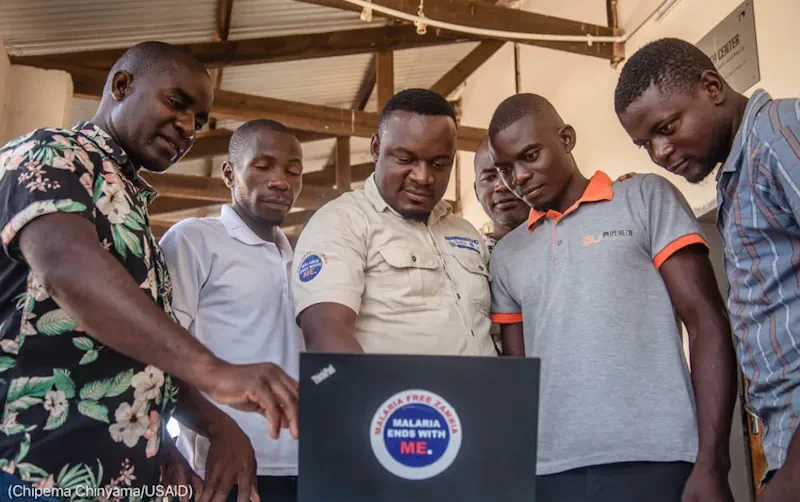
For malaria elimination officer Jerry Maambo, protecting eastern Zambia’s residents from the mosquito-borne disease starts with knowing where people live. Maambo and his team are working to curb rising malaria cases in the Katete district, where cases surged by nearly 50% in 2020 over the previous year. Malaria infects more than 200 million people annually ...

울산시, 방사능재난 대비 ‘시민행동 알림체계’ 시연회

울산시는 31일 오후 2시 시청 제2별관 4층 재난안전상황실에서 ‘방사능재난 대비 시민행동 알림체계(시스템)’ 시연회를 개최한다고 밝혔다. 이 시스템은 대규모 대피가 예상되는 방사능재난 상황 발생 시 시민들의 신속한 대피를 지원하기 위해 구축됐다. 또 흩어져 있는 각종 방사능재난 관련된 정보를 한곳에 모아 시민들이 쉽고 편리하게 사용할 수 있도록 기능을 구현했다. 한국원자력안전기술원 주민보호 지리정보시스템(PGIS), 국가교통정보센터, 울산시 지능형 교통 체계(ITS) ...
mobile.newsis.com

Geovet 2023 – Expanding Boundaries: Interdisciplinary Geospatial Research For The One Health Era

Since 2001, the GeoVet conference, held every 3 years, brings together a diverse group of international experts in spatial epidemiology, spatial statistics and Geographical Information Systems applied to animal health, public health and food safety. From September 19ᵗʰ to 21ˢᵗ 2023, in Silvi Marina, Teramo – Italy, experts from different disciplines will share their knowledge ...
eurekalert.org