Geomaticians

Global Warming

Caltech-Led Mission To Map Greenhouse Gas Emissions Named Finalist By NASA

Caltech-Led Mission To Map Greenhouse Gas Emissions Named Finalist By NASA

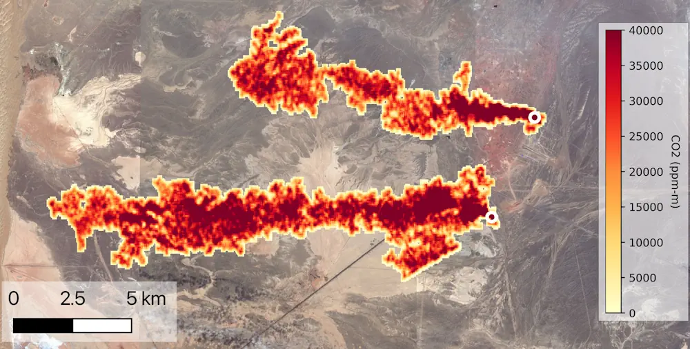
NASA has selected Carbon-I, a proposal to map carbon dioxide (CO2) and methane (CH4) emissions globally at a higher-than-ever resolution, as a finalist for an upcoming space mission. Carbon-I, which is short for the Carbon Investigation, was among four proposals selected to receive $5 million for a one-year feasibility study. After the feasibility studies are ...
caltech.edu
Satellite Data Illuminate Carbon Sequestration Success In Drought-Stricken Southwest China

Satellite Data Illuminate Carbon Sequestration Success In Drought-Stricken Southwest China

Recent research highlights a significant rise in Southwest China’s aboveground carbon levels between 2013 and 2021, showcasing the area’s capacity to counterbalance the negative impacts of severe droughts. This development emphasizes the vital role of Southwest China as a carbon sink, attributed to substantial ecological efforts and the deployment of cutting-edge remote sensing methodologies. For ...
spacedaily.com

Google To Share Oil And Gas Methane Leaks Spotted From Space

Google and environmental group Environmental Defense Fund on Wednesday unveiled a partnership to expose sources of climate-warming emissions from oil and gas operations that will be detected from space by a new satellite. MethaneSAT will launch next month, one of several satellites that are being deployed to monitor methane emissions across the globe to pinpoint ...
nbcnews.com
Satellite Imagery Analysis Firm Launches Free Greenhouse Gas Tracker

Satellite Imagery Analysis Firm Launches Free Greenhouse Gas Tracker

French satellite imagery analysis provider Kayrros launched a free version of its global methane tracking map Nov. 29 to help hold governments and businesses to account for their emissions. The public platform uses data from the European Space Agency’s Sentinel-5P satellite and a sensor on the International Space Station to provide daily snapshots of the ...
spacenews.com

Younger Trees Champion Carbon Capture As Seen By ESA’s Biomass Earth Explorer Satellite

Thanks to their ability to absorb and store carbon dioxide from the atmosphere, forests have long been recognised as a key tool in the fight against climate change – but not all forests are equal. New research based on data from ESA’s SMOS satellite mission has found that, surprisingly, young trees are champions at carbon ...
spaceref.com
Some Emperor Penguin Sites Experienced 'Total Breeding Failure' Because Of Sea Ice Loss

Some Emperor Penguin Sites Experienced ‘Total Breeding Failure’ Because Of Sea Ice Loss

Using satellite images, scientists at the British Antarctic Survey were able to see that sea ice in the central and eastern Bellingshausen Sea region last year broke up long before the start of the birds’ fledgling period, when penguin chicks would have developed their waterproof feathers. The research, published Thursday in the journal Communications Earth ...
nbcnews.com
Trees Are Moving North From Global Warming. Look Up How Your City Could Change.

Trees Are Moving North From Global Warming. Look Up How Your City Could Change.

As greenhouse gas emissions nudge temperatures higher, trees’ growing ranges are shifting northward, projections from the U.S. Forest Service show. Trees near the southern edge of their geographic ranges — what scientists refer to as “plant hardiness zones” — will be left behind, while northern latitudes will welcome new species from the south. Plant hardiness ...
washingtonpost.com
Carbon Brief Interactive Map

Carbon Brief Interactive Map

Carbon Brief reveals visually just how much the world’s most populous regions have been affected by extreme heat since 2013.
interactive.carbonbrief.org

Mapping The Risks Of Isolation Due To Sea Level Rise Associated With Global Warming

A trio of environmental engineers, two with the University of Canterbury in New Zealand, the third with the University of Maryland, has developed a way to illustrate the impact of sea level rise isolation associated with global warming. In their paper published in Nature Climate Change, Tom Logan, M. J. Anderson and Allison Reilly describe ...
phys.org
Satellite Study Shows Most Forests Around The World Are Becoming Less Resilient To Change

Satellite Study Shows Most Forests Around The World Are Becoming Less Resilient To Change

A small team of researchers with members from institutions in Italy, France and the U.S. has found that most forests around the world are becoming less resilient to environmental changes due to global warming. In their paper published in the journal Nature, the group describes their study of satellite pictures of forested parts of the ...
phys.org

Detectan Influencias Ambientales En La Distribución De Parasitosis Intestinales

Investigadores de la Universidad Nacional de La Plata (UNLP) detectaron la influencia del medio ambiente en la distribución de parasitosis intestinales y estimaron que un calentamiento global hará proliferar esa enfermedad y su dispersión. Para el estudio utilizan el Sistema de Información Geográfica y sensores remotos que les permiten monitorear a distancia el riesgo de ...
grupolaprovincia.com