Geomaticians

GIS

Barcelona Bus Route Removed From Map Apps To Tackle Tourist Overcrowding

While some places will go to any lengths to attract visitors, residents of La Salut neighbourhood in Barcelona are celebrating a move to wipe themselves off the map. For years, residents had complained that they could not get home because the number 116 bus was always crammed with tourists visiting Antoni Gaudí’s Park Güell. The ...
theguardian.com

Microsoft, Siemens Join Forces To Standardize Digital Twin Languages

In a collaborative move with the W3C Consortium, Siemens and Microsoft have announced their commitment to converge the Digital Twin Definition Language (DTDL) with the Thing Description standard from international standards organization, W3C. By unifying both languages, customers are offered consistent modeling experiences, mitigating fragmentation in an evolving IoT landscape. With customers typically deploying a ...
thefastmode.com

The Integrated Transport Centre Signs A MoU With A Leading Japanese Company “Location Mind” In Research And Development

On the sidelines of the 10th session of the Abu Dhabi Japan Economic Council, held in the capital Abu Dhabi, the Integrated Transport Centre (ITC) of the Department of Municipalities and Transport (DMT) in Abu Dhabi signed a strategic Memorandum of Understanding (MoU) with “Location Mind”, a leading Japanese company in the field of research, ...
zawya.com
London Gatwick Airport Builds Geospatial Platform With Esri GIS

London Gatwick Airport Builds Geospatial Platform With Esri GIS

London Gatwick has created a new geospatial platform using Esri’s ArcGIS to support multiple operational areas at the airport, including engineering and environmental services. The system is already making engineering and construction works safer by reducing accidental strikes on buried utilities and enabling better management of the airports biodiversity. London Gatwick is one of the ...
gim-international.com

Geospatial Mapping And AI To Help Tackle Energy Gap In Africa

Energy modellers and researchers have developed a geospatial mapping model they say can help address the electricity access gap in Africa. The model has been developed by the International Energy Agency (IEA), researchers at Massachusetts Institute of Technology, University of Massachusetts Amherst and Electricity Growth and Use In Developing Economies. By mapping which buildings are ...
esi-africa.com

New PSGA Data Will Help Speed Up Emergency Response Times

A new selection of location datasets, including two new products, have been released today (Thursday 28 March) as part of the Public Sector Geospatial Agreement (PSGA). The new data and products have been delivered by Ordnance Survey (OS) and are set to support customers across a range of markets, including the emergency services, sustainability, land ...
gov.uk

Dublin Urban Rivers Life Project Selects ESRI To Reduce Levels Of Wastewater

Geographic information systems (GIS) provider Esri Ireland has been chosed by Dublin Urban Rivers Life (DURL) project to help prevent preventing circa 13 million litres of polluted wastewater from entering Dublin rivers annually. DURL is a joint venture between South Dublin and Dún Laoghaire-Rathdown County Councils, with funding received from the EU Life Programme. It ...
techcentral.ie

Geospatial Commission-Funded Tool Demonstrates Potential For AI To Transform Decisions About Land Use

The Geospatial Commission, part of the Department for Science, Innovation and Technology (DSIT), has partnered with The Alan Turing Institute to explore the role that artificial intelligence (AI) can play in long-term decisions about how to use land. The UK is facing significant and competing pressures for its land. Advances in spatial data science and ...
gov.uk

Organic Farms Can Have Mixed Effects On Pesticide Use Depending On Their Neighbors

Organic agriculture may be as old as dirt, but that doesn’t mean its impacts are fully understood. A team of scientists in the United States and Canada are doing their part to change that. Researchers at UC Santa Barbara, University of British Columbia, and University of Colorado Boulder discovered that organic farming significantly affects the ...
news.ucsb.edu

제주 ‘전자 지도’ 만든다···‘날아다니는 차’ 도입 코앞

제주에서 도심항공 교통(UAM)의 밑그림이 될 ‘지도’가 그려진다. 제주특별자치도는 국토교통부가 주관하는 ‘2024년 고정밀 전자지도 구 축 챌린지’ 사업기관에 선정돼 도시계획·개발, 지하시설물 매설 등 각종 사 업의 기본도로 활용되는 전자지도를 구축한다고 21일 밝혔다. 고정밀 전자지도는 도로, 건물, 하천 등 다양한 인공지물과 자연 지형을 일정한 축척에 따라 기호와 문자, 속성 등으로 표현한 디 지털 지리정보다. 국내에서 제작되는 수치지도 ...
news.zum.com
Crean Plataforma Para Democratizar La Información Histórica De Bogotá De Hace Más De Dos Siglos

Crean Plataforma Para Democratizar La Información Histórica De Bogotá De Hace Más De Dos Siglos

Con la intención de acercar y facilitar el acceso a toda la información de Bogotá, la Sociedad de Mejoras y Ornato de Bogotá creó la plataforma digital DataCivilidad, una herramienta que recoge cientos de miles de datos de la capital desde hace más de dos siglos para que, tanto personas naturales como organizaciones estatales y ...
diariodelcauca.com.co

Investigadores De La UJA Y Guatemala Colaboran En El Desarrollo De Técnicas Que Ayuden A Documentar Y Preservar El Patrimonio

Los grupos de investigación ‘Informática Gráfica y Geomática’ y ‘Tecnologías Avanzadas en Ingeniería Civil: Construcción y Transporte Terrestre’ de la Universidad de Jaén mantienen desde hace unos años una intensa colaboración en materia de investigación y docencia con la Facultad de Arquitectura de la Universidad de San Carlos de Guatemala (FARUSAC). Fruto de esta cooperación ...
ondacerojaen.es

Geospatial Commission Joins UK Centre For Seabed Mapping

The Geospatial Commission had today (Wednesday 20 March) become the 31st member of the UK Centre for Seabed Mapping (UK CSM). The UK CSM, which is administered by the UK Hydrographic Office (UKHO), was created in June 2022 to spearhead a coordinated approach to the collection, management and access of seabed mapping data and to ...
gov.uk

Conferenza Nazionale Di Geomatica E Informazione Geografica #ASITA2024 Primo Annuncio E Call For Abstract

ASITA è il luogo dove professionisti, docenti, ricercatori, tecnici e professionisti, soggetti istituzionali e territoriali, società commerciali e più in generale tutti coloro che operano nei diversi campi della Geomatica possono confrontarsi su temi specifici, promuovendo una visione multidisciplinare e integrata del settore della Geomatica nel tentativo di delineare le cosiddette “best practices” utili ad ...
rivistageomedia.it

Nueva Alianza Entre Organismos Nacionales Para Mejorar La Información Geográfica Marítima Y Terrestre

El Ministerio de Transportes y Movilidad Sostenible ha anunciado la firma de un protocolo con el Ministerio de Defensa, específicamente con la Armada, para fomentar la colaboración entre el Instituto Geográfico Nacional (IGN), su Centro Nacional de Información Geográfica (CNIG) y el Instituto Hidrográfico de la Marina (IHM). Esta alianza estratégica busca compartir y mejorar ...
elestrechodigital.com

Esri Se Asocia A Acutel Para Hacer Accesible Su Tecnología Geoespacial A Los Operadores De Telecomunicaciones Neutros Y Locales

Esri, empresa líder en tecnología geoespacial, ha firmado un acuerdo de colaboración con Acutel, la Asociación Nacional de Operadores de Telecomunicaciones y Televisión Local de España, entidad que aglutina a casi 250 compañías que ofrecen servicios de internet, telefonías fija y móvil y televisión, y cuyo objetivo es que los operadores de telecomunicaciones locales puedan ...
dirigentesdigital.com

Saudi Ministry Launches GIS-Enabled Digital Platform For Water Management

The Ministry of Environment, Water, and Agriculture has announced a significant step forward in water management and planning by signing a contract to establish a geographical information system (GIS) for water planning. This initiative aims to create a smart water digital platform aligning with international best practices for the water sector within the Kingdom. Dr. ...
zawya.com

California Is Finally Digitizing Its 100-Year-Old Paper Water Rights

In a Sacramento office building, university students carefully scan pieces of paper that underpin California’s most contentious and valuable water disputes. One by one, they’re bringing pieces of history into the digital era, some a century old and thin as onion skin. The massive undertaking will unmask the notoriously opaque world of California water. Right ...
insider.govtech.com
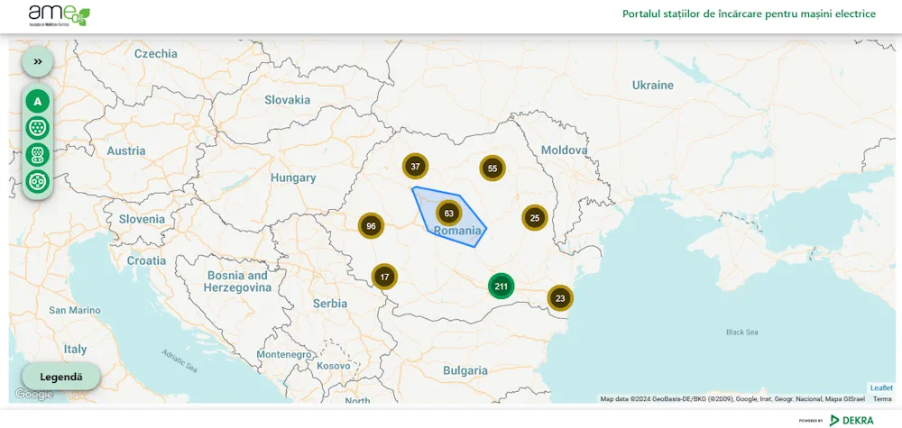
Romania’s Energy Ministry Makes Map Of EV Charging Points Available

Romania’s Energy Ministry Makes Map Of EV Charging Points Available

A map with charging points for electric cars was recently unveiled by Romania’s Energy Ministry. The map is featured on the website of the institution, and was made in partnership with local authorities across the country. Romanian energy minister Sebastian Burduja said that the map is part of the EU-wide project of reaching 75 million ...
romania-insider.com
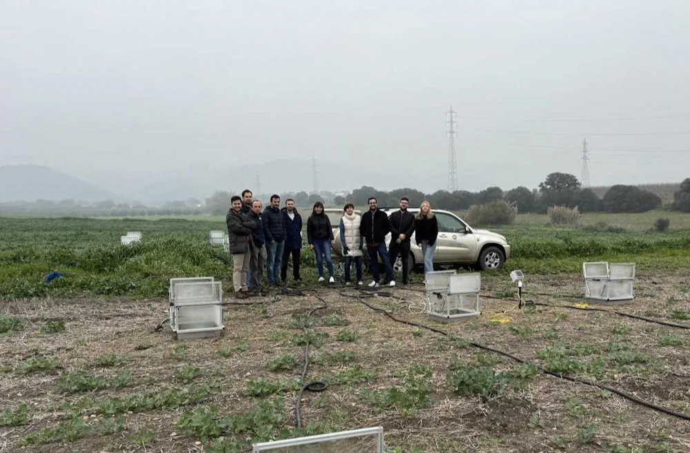
Investigadores De La UCO Y La UMA Trabajan En El Desarrollo De Un Gemelo Digital De Una Finca De Regadío

Investigadores De La UCO Y La UMA Trabajan En El Desarrollo De Un Gemelo Digital De Una Finca De Regadío

Una experiencia piloto en el Campus de Rabanales será la base del proyecto GEDIER, que busca crear un sistema de apoyo a la toma de decisiones para una gestión más eficiente de los recursos Avanzar hacia un uso plenamente eficiente de los recursos es el reto más ambicioso al que se enfrenta la agricultura, tanto ...
aenverde.es
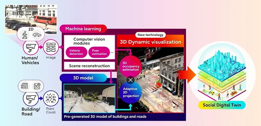
Fujitsu And Carnegie Mellon University Develop AI-Powered Social Digital Twin Technology With Traffic Data From Pittsburgh

Fujitsu And Carnegie Mellon University Develop AI-Powered Social Digital Twin Technology With Traffic Data From Pittsburgh

Fujitsu Limited and Carnegie Mellon University today announced the development of a new technology to visualize traffic situations, including people and vehicles, as part of joint research on Social Digital Twin that began in 2022. The technology transforms a 2D scene image captured by a monocular RGB camera (1) into a digitalized 3D format using ...
fujitsu.com
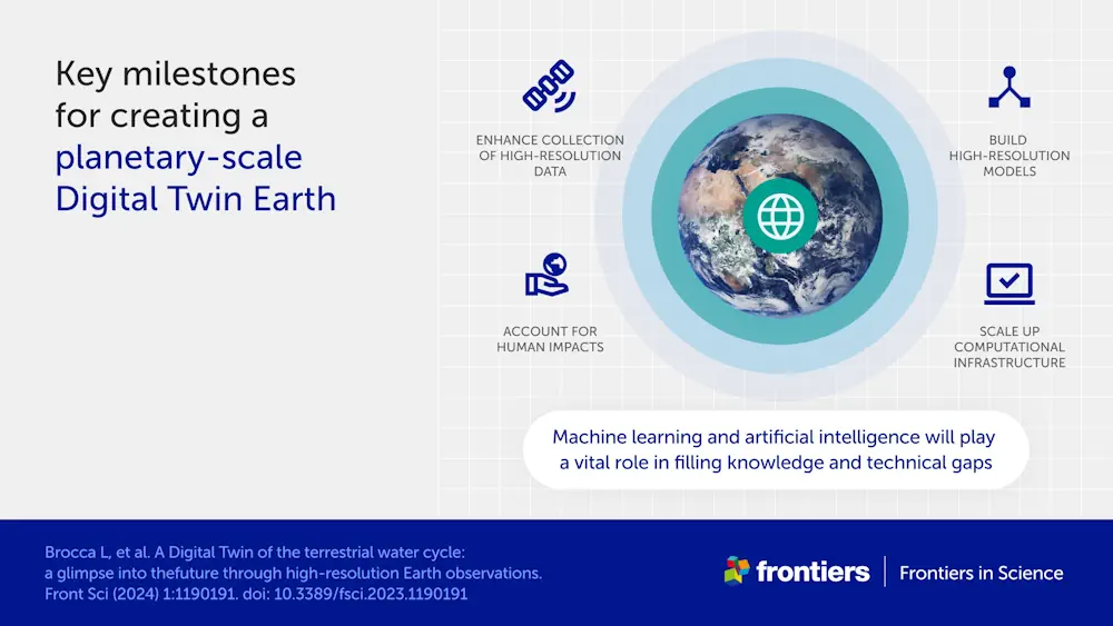
New 'Digital Twin' Earth Technology Could Help Predict Water-Based Natural Disasters Before They Strike

New ‘Digital Twin’ Earth Technology Could Help Predict Water-Based Natural Disasters Before They Strike

The water cycle looks simple in theory—but human impacts, climate change, and complicated geography mean that in practice, floods and droughts remain hard to predict. To model water on Earth, you need incredibly high-resolution data across an immense expanse, and you need modeling sophisticated enough to account for everything from snowcaps on mountains to soil ...
phys.org

Philsa, DENR Team Up To Create Mangrove Map Using Satellite Data

The Philippine Space Agency (PhilSA) and the Department of Environment and Natural Resources (DENR) have collaborated to develop a nationwide mangrove map using remote sensing data, a vital tool for conservation efforts. The mangrove mapping initiative is part of the DENR’s development of a national geospatial database for its environment and natural resource accounting program. ...
philstar.com
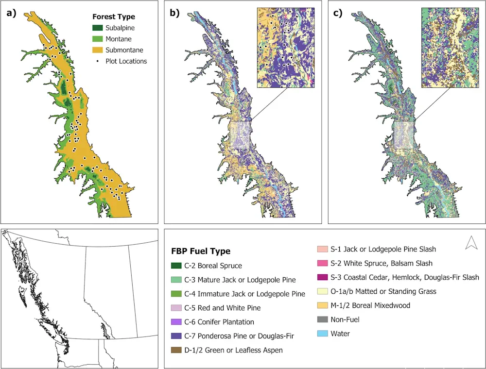
Inaccurate Government Data May Be Stoking Wildfires UBC Study

Inaccurate Government Data May Be Stoking Wildfires: UBC Study

Wildfire fighting and forest management decisions are potentially being hampered by inaccurate government data that misrepresents forest fuel loads in British Columbia’s Interior, a new study has found. The B.C. government says the provincial wildfire service is working with the study’s lead author and others to close the data gap, which involves “mismatches” between remotely-sensed ...
cbc.ca
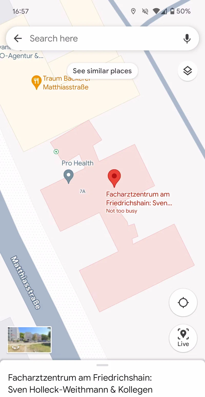
Google Maps Tests Showing Building Entrances

Google Maps Tests Showing Building Entrances

Google Maps has become an invaluable tool to navigate and to find the best spots to eat, get coffee, or to see sights. But with some bigger buildings and attractions, it can get hard to find the entrance. That’s where a new experiment comes in that Google appears to be testing with a few users ...
androidpolice.com
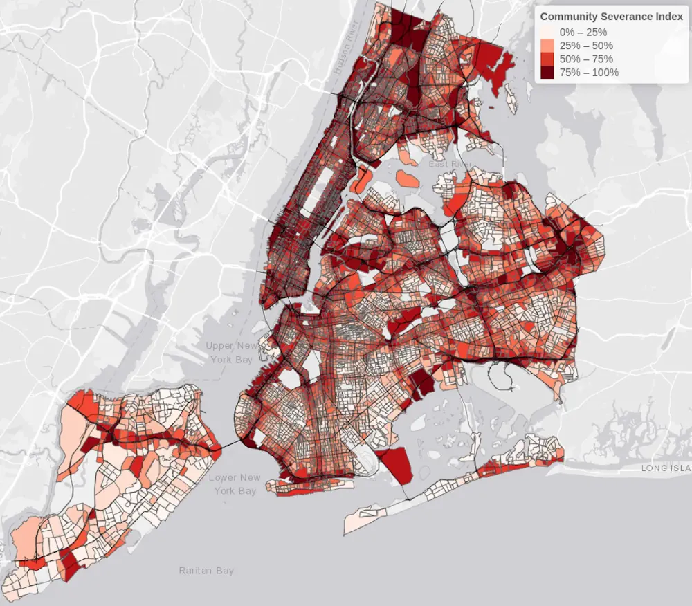
Communities Severed By Roads And Traffic Experience A Larger Number Of Collisions In New York City

Communities Severed By Roads And Traffic Experience A Larger Number Of Collisions In New York City

New York City neighborhoods with disrupted community connections, due to traffic, roads, and transport infrastructure, are experiencing an increase in traffic collisions. This increase is seen both in total collisions and for those in which pedestrians or cyclists are injured or killed, according to a new study from Columbia University Mailman School of Public Health. ...
phys.org

Combining Big Data And Machine Learning To Predict Power Outages And Help Consumers Prepare

Unplanned power outages due to environmental conditions (wind, lightning, tree growth, etc.) leave those without power on their own, sometimes for long periods of time. Utility companies lack the ability to predict when forced outages will occur, so no mitigation measures targeting consumers are deployed ahead of time to reduce the impact of an outage. ...
techxplore.com
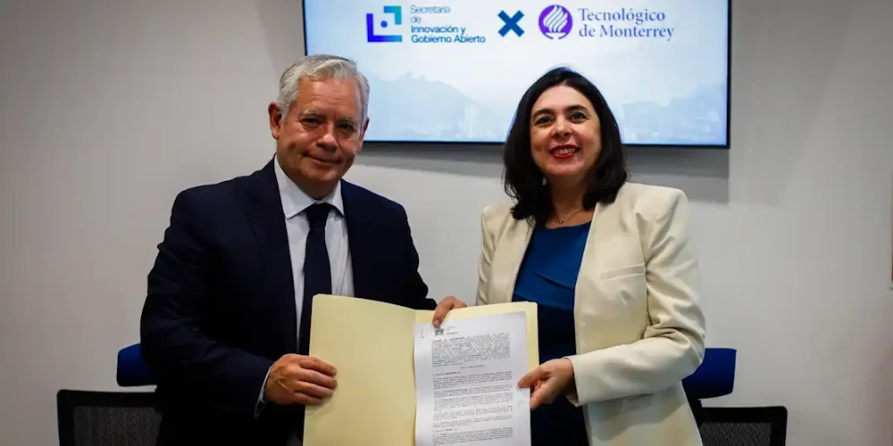
Tendrá Monterrey Su “Gemelo Digital”

Tendrá Monterrey Su “Gemelo Digital”

El Gobierno de la Ciudad y el Tecnológico de Monterrey firmaron un convenio de colaboración para desarrollar una réplica virtual del territorio del municipio, comúnmente conocida como “gemelo digital”. Se trata de una representación virtual de la ciudad que será construida a partir de la cartografía con la que cuenta el Gobierno Municipal en conjunto ...
detona.com
IHME, Microsoft, And Planet Collaborate To Map Climate-Vulnerable Populations In Unprecedented Detail

IHME, Microsoft, And Planet Collaborate To Map Climate-Vulnerable Populations In Unprecedented Detail

Climate change intensifies disasters, which drives displacement. That can, among many impacts, push internally displaced people from rural areas into urban slums. That in turn raises the risks of forced evictions and secondary urban displacement, as well as increased risks of public health crises, and so on, in a dispiriting causal chain. Knowing, in detail, ...
planet.com

MoSPI Signs MoU With ISRO On Urban Frame Survey Using Bhuvan

The NSSO (FOD) under Ministry of Statistics and Programme Implementation (MoSPI) has entered into a Memorandum of Understanding (MoU) with the National Remote Sensing Centre (NRSC) under the Indian Space Research Organization (ISRO) to facilitate Urban Frame Survey (UFS) in a digital mode using the state-of-the-art Geo ICT tools and techniques using Bhuvan Platform. The ...
pib.gov.in