Geomaticians

GIS

Tube Map Redesigned By Essex Lecturer Goes Viral

Tube Map Redesigned By Essex Lecturer Goes Viral

A new version of the London Underground map designed by a University of Essex lecturer has gone viral. Harry Beck’s 1933 Tube map is the one people usually use, but Maxwell Roberts, from Walton-on-the-Naze, created his own version in 2013. Mr Roberts has now updated his creation, and it has had a million engagements within ...
bbc.com
How You Can Use Google Maps To Track Wildfires And Air Quality

How You Can Use Google Maps To Track Wildfires And Air Quality

Climate change has brought an increasing number of wildfires and air quality problems. In the US, the West Coast has seen more than its fair share of fires over the past several years. Here on the East Coast, we were affected by wildfires in Canada last year, creating a haze across the skies and warnings ...
zdnet.com
Estudo Com Participação De Professor Da UFPB Aponta Perda De Habitat Vital Em Rio Nos Estados Unidos

Estudo Com Participação De Professor Da UFPB Aponta Perda De Habitat Vital Em Rio Nos Estados Unidos

Um estudo realizado com a participação de um docente da Universidade Federal da Paraíba (UFPB) aponta que entre os anos de 2001 e 2019, houve uma perda contínua de habitat vital no rio Mobile-Tensaw do Alabama nos Estados Unidos. Os dados utilizados no estudo foram obtidos por meio de sensoriamento remoto, modelagem geoespacial e análises ...
ufpb.br
Las Médulas Impulsan Su Turismo Ecológico Gracias A Una Beca RALBAR

Las Médulas Impulsan Su Turismo Ecológico Gracias A Una Beca RALBAR

Raquel Vega, estudiante del grado en Ingeniería Geomática y Topografía en el campus de Ponferrada de la Universidad de León (ULE), presentó su proyecto ‘Médulas Bioreseve: conservación de la biodiversidad y turismo ecológico’ al programa de Becas RALBAR de la ULE y la Fundación Banco Sabadell y fue seleccionado para desarrollarlo durante este verano en ...
infobierzo.com
La Agencia Nacional De Seguridad Vial Lanza Nueva Herramienta Para La Seguridad Vial

La Agencia Nacional De Seguridad Vial Lanza Nueva Herramienta Para La Seguridad Vial

El Centro de Gestión de Seguridad Vial (CGSV) es una herramienta avanzada que, a través de un visor web, permitirá a los usuarios visualizar datos de seguridad vial en mapas, tableros de control y reportes de manera intuitiva y amigable. Este aplicativo es auspiciado por la Agencia Nacional de Seguridad Vial (ANSV) y desarrollado por ...
caracol.com.co
La Lucha Contra Los Incendios Suma IA Y Tecnología Geoespacial Para Identificar Los Focos De Manera Temprana Y Precisa

La Lucha Contra Los Incendios Suma IA Y Tecnología Geoespacial Para Identificar Los Focos De Manera Temprana Y Precisa

La época estival es la más crítica del año en lo que a incendios se refiere, por ello contar con un sistema que permita identificar los focos de manera temprana y que geolocalice con precisión la ubicación de las llamas puede inclinar la balanza hacia el éxito en la lucha contra el fuego. Una red ...
lavanguardia.com
Where Is Plastic Produced

Where Is Plastic Produced?

There is a lot of concern about microplastics, as they have been found just about everywhere- from isolated Rocky Mountain lakes to the deepest part of the ocean, as well as in our own bodies. When we think about microplastics, most people think about broken down bits of larger plastic items. However, the origin of ...
environmentamerica.org
CopernicusLAC Chile Lanza Inéditos Servicios De Mapas De Cobertura Y Uso De Suelos Y Atlas Urbano Para América Latina Y El Caribe

CopernicusLAC Chile Lanza Inéditos Servicios De Mapas De “Cobertura Y Uso De Suelos” Y “Atlas Urbano” Para América Latina Y El Caribe

De libre acceso, inicialmente con 12 tipos de superficies de datos (7 de suelos y 5 de ciudades) y diseñados en el Centro de Modelamiento Matemático de la Facultad de Ciencias Físicas y Matemáticas de la Universidad de Chile. El Centro Regional Copernicus para América Latina y el Caribe (CopernicusLAC Chile), anunció el inicio de ...
uchile.cl
SAMUDRA App Benefitting Fishing Communities

SAMUDRA App Benefitting Fishing Communities

The Indian National Centre for Ocean Information Services (INCOIS), operating under the Ministry of Earth Sciences (MoES), has launched a mobile application named ‘SAMUDRA’ (Smart Access to Marine Users for Ocean Data Resources and Advisories). “SAMUDRA” is envisioned to give easy access for users to the ocean information and advisory services. This app serves as ...
geospatialworld.net
TÜBİTAK Updates Türkiye's Earthquake Map With Active Fault Data

TÜBİTAK Updates Türkiye’s Earthquake Map With Active Fault Data

The Scientific and Technological Research Council of Türkiye (TÜBİTAK) is working on updating Türkiye’s earthquake hazard map, TÜBİTAK President Hasan Mandal reported recently, to share a comprehensive list of active and live fault lines with the public by the end of 2025. Under the leadership of TÜBİTAK, in collaboration with the Disaster and Emergency Management ...
dailysabah.com
French Watchdog Publishes Map Of Beaches Where Swimmers Risk Illness

French Watchdog Publishes Map Of Beaches Where Swimmers Risk Illness

You can now consult a list of places to avoid or target as an environmental watchdog has published a map showing the water quality at 1,854 beaches in France. The map comes from environmental association Eau et Rivières de Bretagne (ERB), which recently published a study showing that one in five beaches in France was ...
connexionfrance.com

Land Records To Be Digitised Separately For Urban And Rural Areas: FM Sitharaman

Recorded manually ever since the charting of land rights began, land records are awaiting a digital makeover. Thanks to the Geographic Information System (GIS), land record digitization has become possible. Coupled with methods such as Satellite Imagery and Airborne Surveys, accurate mapping of land has been on the cards for over a decade in India. ...
geospatialworld.net

New App Maps Out Addis Ababa’s Public Transport Routes

Seven-year-old company Bandira AddisMap Enterprise (BAME) has launched a public transport route management app after comprehensively mapping out the capital’s public transport network. Boosted by a $30,000 fund secured by winning the Digital Transport 4 Africa Innovation Challenge two years ago and a collaboration with the Trufi Association, an international NGO promoting easier access to ...
shega.co

QU Leads Research To Enhance Food, Water Security In Arid Regions

Qatar University (QU) is directing research into improving the sustainability of food and water security in arid regions. Dr Ammar Abulibdeh, an associate professor of geography and GIS (geographic information system) at the QU’s College of Arts and Sciences, leads the research team focused on developing a comprehensive model to interconnect food, water, and ecosystems ...
gulf-times.com

Seychelles To Introduce National Addressing System, Pilot Rollout Planned For March 2025

The Seychelles’ Cabinet of Ministers has approved the implementation of the National Addressing System (NAS) to provide a standardised, accurate, and efficient addressing framework to improve service delivery. In a cabinet decisions press briefing on Thursday, Vice President Ahmed Afif said that Seychelles, unlike other countries, does not have a postal code, which is a ...
seychellesnewsagency.com
Geospatial Information Knowledge Platform (GeoIKP)

Geospatial Information Knowledge Platform (GeoIKP)

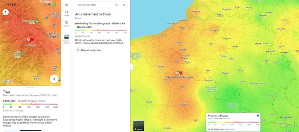
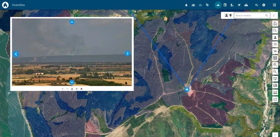
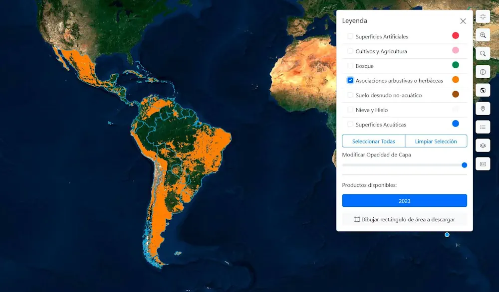
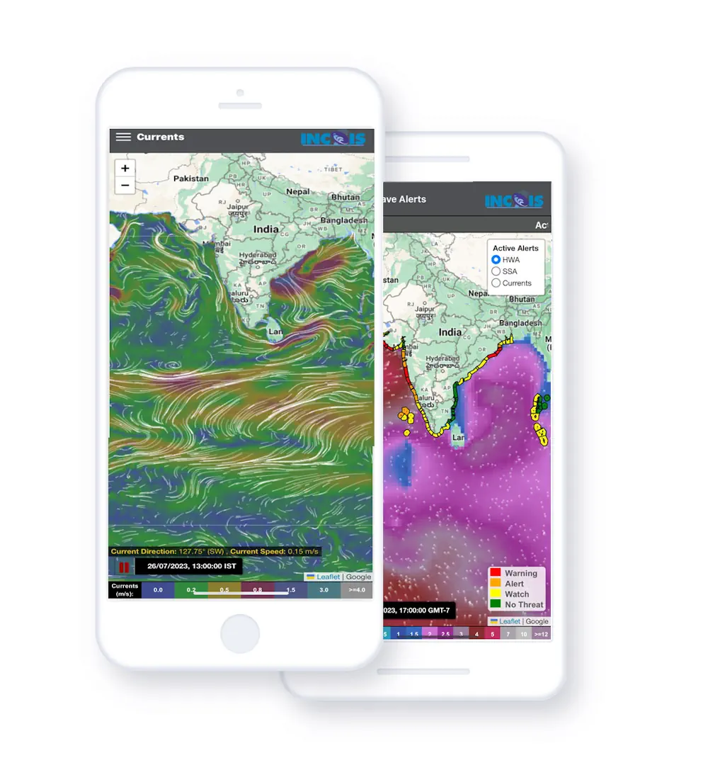
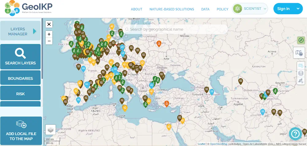
The Geospatial Information Knowledge Platform (GeoIKP) is a collaborative environment designed to support the development and implementation of Nature-Based Solutions (NBS) for mitigating hydro-meteorological hazards. It facilitates access to data, tools, and knowledge exchange, aiding decision-making for citizens, policymakers, companies, scientists, and other users. Developed within the OPERANDUM project (2018-2022), the platform promotes sustainable solutions ...
unesco.org
Designing A Decision-Support Tool For Climate Adaptive Urban Planning

Designing A Decision-Support Tool For Climate Adaptive Urban Planning

Heat stress and air pollution ravages cities more and more. In a new Horizon Europe project, researchers will develop a digital twin that supports decision makers to design resilient urban areas that can cope with the changing climate. Researchers from TU Delft and 18 other partners receive the Horizon Europe grant for their project called ...
tudelft.nl
Project To Show Insights Into New Zealand’s Exotic Forests

Project To Show Insights Into New Zealand’s Exotic Forests

A research project to capture an inventory of all exotic planted forests in New Zealand could provide a valuable tool for commercial forestry decisions. Crown Research Institute Scion showed Forest Insights at its stand at Mystery Creek in June, as part of the 2024 Fieldays Forestry Hub. Grant Evans is Scion’s new value digital forests ...
nzherald.co.nz
China And Malaysia Collaborate On “Digital Twin Cities” Project To Drive Data Innovation

China And Malaysia Collaborate On “Digital Twin Cities” Project To Drive Data Innovation

China’s Lingang New Area and Malaysia’s Cyberjaya have joined forces to launch the “Digital Twin Cities” project, marking a significant step forward in global data innovation collaboration. This initiative, signed on July 9th, establishes a framework for cooperation in eight key areas, including data economy, cross-border data flows, and policy support. The project leverages the ...
w.media
“Balady Maps”, A Navigation Feature Enabling Users To Quickly Access Locations Within Saudi Cities

“Balady Maps”, A Navigation Feature Enabling Users To Quickly Access Locations Within Saudi Cities

Balady App provides users with an advanced navigation system through the “Balady Maps” feature, which includes a set of data and information updated daily, needed by city residents and visitors for easy navigation and reaching their destinations. This feature is part of the efforts of the Ministry of Municipal, Rural Affairs and Housing to enhance ...
momrah.gov.sa
This Is How Much Hotter Urban Sprawl Makes US Cities Feel

This Is How Much Hotter Urban Sprawl Makes US Cities Feel

Nearly 34 million people across 65 US cities — roughly one in 10 Americans — live in a place where the built environment makes temperatures feel at least 8 degrees Fahrenheit hotter than it would without that urban sprawl. That’s according to a new study by the nonprofit Climate Central, which mapped the impact of ...
theverge.com
Wellington Launches Platform To Map Underground Infrastructure

Wellington Launches Platform To Map Underground Infrastructure

New Zealand’s capital, Wellington, has become the first city in the country to create an online data sharing platform to map all underground infrastructure either owned by the city or other utility operators. The platform will map buried pipes and cables that could save infrastructure organisations millions of dollars each year. The platform aims to ...
cities-today.com
How A Texas Man Turned Whataburger Into The State’s Power Outage Tracker

How A Texas Man Turned Whataburger Into The State’s Power Outage Tracker

Hurricane Beryl had pummeled Southeast Texas on Monday, leaving millions in the Houston area without power. But with technical issues plaguing the tracker for the city’s main energy provider, there was no way to check the status of power outages — or find the still-lit pockets where residents could buy food, gas and other necessities. ...
w.washingtonpost.com
New Map Reveals Red Zones For Pedestrian Safety Risks

New Map Reveals Red Zones For Pedestrian Safety Risks

“Speed kills” is such a well-known mantra in transportation advocacy circles it’s at risk of becoming trite. So how can activists find new ways to communicate the crucial linkage between speeding drivers and the fatal crashes they cause? One answer to that question comes from a project by Portland Community College Student Jake Veto. Veto ...
bikeportland.org

CARTO Introduces AI Agents To Expand Access To Spatial Analytics

CARTO, the cloud-native spatial analysis platform, today announced the launch of CARTO AI Agents in private preview, the industry-leading AI tool that combines geospatial technology with AI. AI Agents enable decision-makers to address vital spatial questions quickly, democratizing access to spatial analytics and driving improved decision-making. The introduction of AI Agents aligns with the release ...
datanami.com
Felt Upgrades GIS Platform

Felt Upgrades GIS Platform

Felt has introduced Felt 3.0, which includes new features and native database integrations to improve Geographic Information Systems (GIS) capabilities. The goal of Felt 3.0 is to make data more accessible and actionable for stakeholders. It provides modern GIS tools for teams to visualize, analyze and present important insights and map data relevant to their ...
gpsworld.com
Govt Preparing One Map Policy Sustainability Document

Govt Preparing One Map Policy Sustainability Document

Coordinating Minister for Economic Affairs, Airlangga Hartarto, informed that the government is preparing a White Paper One Map Policy Beyond 2024, a document for the continuation of the One Map Policy, for the next government. “Based on the strategic value and usefulness of the One Map Policy, a White Paper One Map Policy Beyond 2024 ...
en.antaranews.com
Google Maps Patent Hints At A Multi-car Navigation Feature, Enabling Easier Group Travel

Google Maps Patent Hints At A Multi-car Navigation Feature, Enabling Easier Group Travel

Google Maps is one of the most widely used navigation apps in the world, with 60 million active users in India alone as of 2023, according to Miriam Daniel, Vice President and Head of Google Maps. The web mapping platform introduces new features and improvements to existing ones on a regular basis, helping solo travellers ...
gadgets360.com

Turkmenistan Advances Land Reform With New Administration System

Turkmenistan is currently in the process of establishing a comprehensive land administration system, which includes both a cadastre and a land registration system. Since 1990, the official land statistics of Turkmenistan have shown minimal individualization. This is largely due to the fact that former collective farms still list land now held in family leaseholds as ...
daryo.uz
New Map Shows The Highest Heat Risk Isn’t Always Where Temperatures Are Hottest

New Map Shows The Highest Heat Risk Isn’t Always Where Temperatures Are Hottest

An interactive map created by the Centers for Disease Control and Prevention rates each ZIP code in the mainland U.S. to identify areas “most likely to experience negative health outcomes from heat.” But CDC’s Heat and Health Index shows that heat risk is about much more than temperatures. Heat vulnerability varies sharply within cities and ...
scientificamerican.com