Geomaticians

GIS

Desarrollan Una Plataforma Con Información Espacial Para La Vigilancia De Enfermedades

Desarrollan Una Plataforma Con Información Espacial Para La Vigilancia De Enfermedades

La Comisión Nacional de Actividades Espaciales (CONAE) finalizó el desarrollo de un sistema integrado de vigilancia basado en información espacial para enfermedades transmitidas por vectores, que próximamente estará online para el uso del público en general, gobiernos locales e instituciones de la salud pública. La herramienta fue desarrollada completamente con software libre y de código ...
argentina.gob.ar

Survey And Geospatial Information Authority Releases Official Map Of Saudi Arabia

Saudi Arabia’s General Authority for Survey and Geospatial Information announced on Monday that it is the national authority responsible for producing the official map of the Kingdom with approved international borders. It also said it is responsible for providing maps to all government agencies, the private sector, the academic sector, individuals, and the media, Saudi ...
arabnews.com

Association For Royal Geographical Society Renew Collaboration

The Association for Geographic Information (AGI), the UK membership organisation for companies and individuals working in the geospatial sector, and the Royal Geographical Society (with the Institute of British Geographers) (RGS-IBG) have signed a new Memorandum of Understanding (MoU). This strategic alliance, in alignment with both organisation’s objectives and strategies, will strengthen communications to maximise ...
directionsmag.com
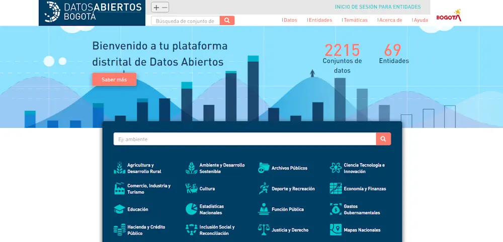
¿Sabías Que Hay Un Portal Web Con Más De 2.200 Datos Sobre Bogotá Conócelo Aquí

¿Sabías Que Hay Un Portal Web Con Más De 2.200 Datos Sobre Bogotá? Conócelo Aquí

El portal web Datos Abiertos Bogotá es una plataforma digital que reúne un vasto y diverso conjunto de datos geográficos y alfanuméricos que pueden ser útiles para investigadores, docentes, veedores, estudiantes y ciudadanía, interesados en explorar el pulso de la ciudad. El portal alberga una colección de más de 2.200 conjuntos de datos, publicados de ...
bogota.gov.co

Disponible El Sistema De Información Sobre Ocupación Del Suelo En España De Alta Resolución

El Sistema de Información sobre Ocupación del Suelo en España (SIOSE) de alta resolución, completado y publicado por el Ministerio de Transportes, Movilidad y Agenda Urbana (Mitma), describe la superficie terrestre de España en términos de cubiertas y usos del suelo. Esta información es fundamental para la gestión del territorio en aplicaciones públicas y privadas. ...
esmartcity.es
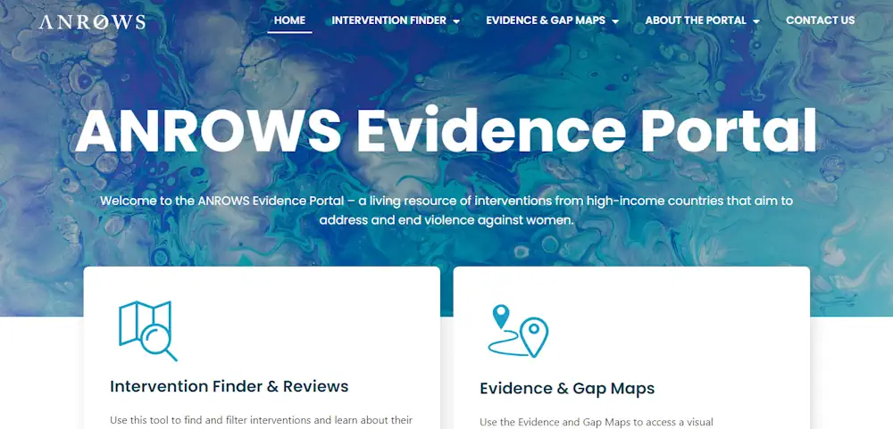
Open Access To Evidence On Family, Domestic And Sexual Violence

Open Access To Evidence On Family, Domestic And Sexual Violence

From today, anyone around the world will be able to access an Australian-led data initiative aimed at reducing the rates of family, domestic and sexual violence. The Evidence Portal is a new online tool created and maintained by Australia’s National Research Organisation for Women’s Safety (ANROWS), one of the leading research organisations in Australia on ...
ministers.dss.gov.au
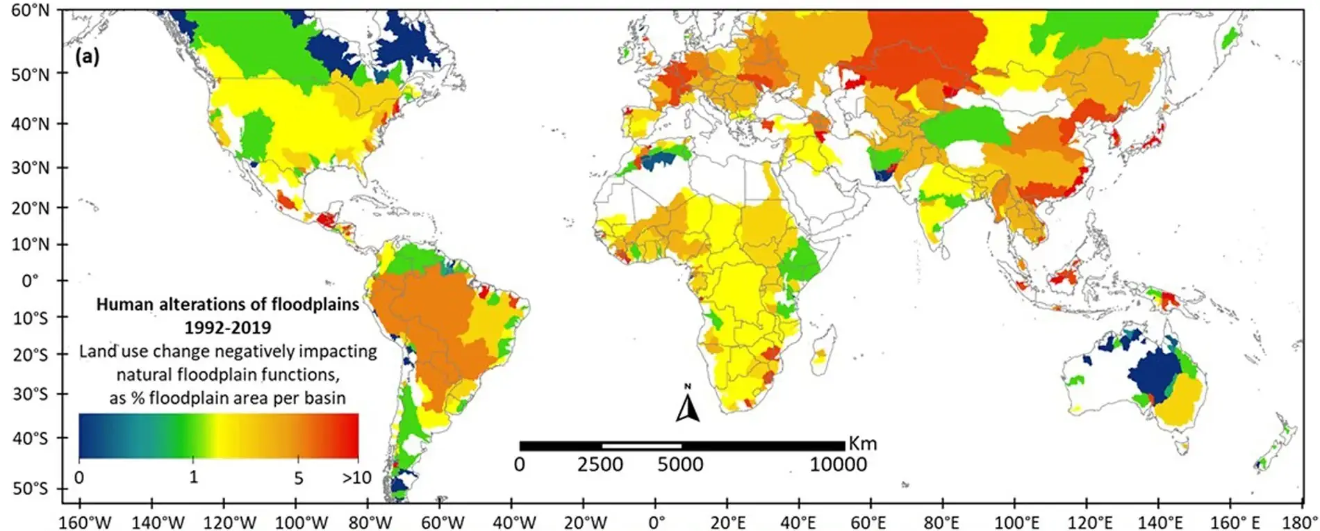
Study Reveals Human Destruction Of Global Floodplains

Study Reveals Human Destruction Of Global Floodplains

A University of Texas at Arlington hydrologist’s study in the Nature journal Scientific Data provides the first-ever global estimate of human destruction of natural floodplains. The study can help guide future development in a way that can restore and conserve vital floodplain habitats that are critical to wildlife, water quality and reducing flood risk for ...
eurekalert.org
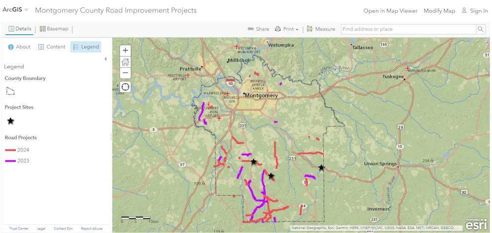
Track Montgomery County Road Projects With New Interactive Map

Track Montgomery County Road Projects With New Interactive Map

You have a new way to find out about road improvement projects in Montgomery County. A new interactive road improvement map has been launched online. It’s a new digital tool that provides information about recent and upcoming road projects. Using the GIS system, the map allows you to see which roads are set to be ...
waka.com

Lanzan Consulta Ciudadana Para Definir La Primera Política Nacional De Información Geoespacial De Chile

Los datos geoespaciales que levanta la IDE Chile (Infraestructura de Datos Geoespaciales de Chile) desde el Ministerio de Bienes Nacionales, han sido claves para Chile. Dicha información, que ha sido un insumo fundamental para las autoridades, y también para la investigación y el mundo privado, no contaba con una Política Nacional de Información Geoespacial. Hasta ...
latercera.com

Online Mapping Tool To Identify Policy-Suitable Land For Renewables

Researchers at the University of Strathclyde have created a new geospatial mapping tool that enables developers to identify land for renewable energy development that complies with both policy and technical requirements. Called Geospatial Opportunity Mapping (GOMap), the new tool is built on the available QGIS framework. “External plugins have been developed specifically for QGIS to ...
pv-magazine.com
Kaleiçi’ndeki Haritalandırma Çalışması Tamamlandı Kaynak Kaleiçi’ndeki Haritalandırma Çalışması Tamamlandı

Kaleiçi’ndeki Haritalandırma Çalışması Tamamlandı Kaynak: Kaleiçi’ndeki Haritalandırma Çalışması Tamamlandı

Türkiye’nin ilk sakin şehri Seferihisar’ın, tarihi Kaleiçi bölgesi ile ilgili yapılan haritalandırma çalışması tamamlandı. Kaleiçi’ne gelen ziyaretçiler, giriş noktalarına yerleştirilen haritalar üzerindeki karekodu okutarak, gitmek istedikleri adrese kolaylıkla ulaşabilecekler.Seferihisar Belediyesi, Sığacık’ta bulunan tarihi Kaleiçi bölgesi ile ilgili haritalandırma çalışması yaptı.Her yıl, on binlerce yerli ve yabancı turistin ziyaret ettiği ve araç girişinin olmadığı bölgede, adreslerin ...
turkiyeturizm.com

Le Géoportail De Santé Publique : Un Allié Pour Les Interventions En Santé

Le Géoportail de santé publique du Québec est une plateforme cartographique qui permet de visualiser la variation géographique d’indicateurs de santé et de ses déterminants partout au Québec. La plateforme est accessible à tous les organismes ainsi qu’au grand public. Des indicateurs sont aussi disponibles en lien avec la qualité de l’air et bruit environnemental, ...
cdeacf.ca

Ecuador Crea Su Primer Atlas Geográfico Y Estadístico Ambiental Y De Los Recursos Hídricos

Ecuador presentó su primer Atlas Geográfico y Estadístico Ambiental y de los Recursos Hídricos para facilitar el acceso a información oficial actualizada, validada y confiable sobre el patrimonio natural y los recursos hídricos, informó este viernes el Ministerio del Ambiente, Agua y Transición Ecológica. Esta herramienta de información está dividida en cinco secciones que contienen ...
lavanguardia.com

Chicago Uses Tech, Resident Input To Improve Services

The map-based Chicago Recovery Plan was created with feedback from residents. It also allows them to track progress on city projects to create safe neighborhoods and drive equitable economic growth. Launched in May 2023, the tool is “opening the books on neighborhood investments in a simple, accessible digital format,” Chief Technology Officer Nick Lucius said ...
govtech.com
Giovani Che Non Studiano Né Lavorano Oxfam Lancia Una Mappa Online Delle Opportunità

Giovani Che Non Studiano Né Lavorano: Oxfam Lancia Una Mappa Online Delle Opportunità

In Toscana ancora oggi oltre il 13,8% dei giovani tra i 15 e i 29 anni non studiano e non lavorano, né partecipano ad attività di formazione. Sono i cosiddetti “Neet”, ragazzi e ragazze che rischiano di restare indietro e non riuscire a costruire il proprio futuro a causa principalmente delle tante disuguaglianze territoriali, di ...
gonews.it
El Metro De Granada Y El Trambahía Recibirán Una Inversión De 2,2 Millones En Transformación Digital Por La Junta

El Metro De Granada Y El Trambahía Recibirán Una Inversión De 2,2 Millones En Transformación Digital Por La Junta

La Consejería de Fomento, Articulación del Territorio y Vivienda invierte 2,2 millones de euros en la implantación de un gemelo digital en el Metro de Granada y en el Trambahía, un novedoso sistema de realidad virtual que permite recrear situaciones que permitan planificar un óptimo mantenimiento de esta infraestructura y mejorar los parámetros de calidad ...
infocostatropical.com

Compulsory For UP Developers To Tag Projects With GIS-based Master Plans

The Uttar Pradesh Real Estate Regulatory Authority (UP RERA) will soon make it mandatory for developers to tag the maps of their projects with the Geographic Information System (GIS)-based master plans in 13 major cities across the state. This move is meant to check whether the upcoming project is on a bona fide site as ...
daijiworld.com
Geospatial Tech Can Help Cities Get Ahead Of Real Estate Speculators

Geospatial Tech Can Help Cities Get Ahead Of Real Estate Speculators

In 2021, investors spent $50 billion purchasing 80,000 homes, accounting for about 18% of all homes sold in the United States that year. And as home prices increase, residential properties grow more attractive to investors who can resell renovated homes for higher prices or charge higher rents. It’s a trend that concerns local leaders nationwide, ...
route-fifty.com

안동시, 국내 석학 초청해 공간정보 발전 포럼 개최

안동시는 지난 29일 국내 공간정보 분야 석학을 초청해 ‘안동시 공간정보 발전 포럼’을 29일 시청 웅부관 청백실에서 개최했다. 시는 최근 국토교통부 ‘디지털 트윈 국토사업’과 국토지리정보원 ‘고정밀 전자지도 챌린저 공모사업’에 선정됐다. 디지털 트윈으로 대표되는 3차원 공간에 안동의 문화유산 콘텐츠와 수자원 인프라 등을 구현해 문화시설과 콘텐츠를 담은 고정밀 전자지도를 구축하고 홍수와 가뭄 등 재해에도 선제적으로 대응하는 다양한 시정 ...
metroseoul.co.kr
El Mapa De Calor Del Ayuntamiento De Madrid Descubre Si Vives En Una Zona Con Temperaturas “Extremadamente Altas”

El Mapa De Calor Del Ayuntamiento De Madrid: Descubre Si Vives En Una Zona Con Temperaturas “Extremadamente Altas”

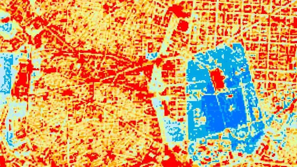
El Ayuntamiento de Madrid ha publicado un mapa en el que cada vecino puede comprobar si vive en un lugar afectado por su isla de calor o, por el contrario, resulta beneficiado gracias a la cercanía de parques como el Retiro, Casa de Campo o espacios de la periferia como Pradolongo, Entrevías o Valdebebas. Estos ...
eldiario.es

Das Geodatenportal Gibt’s Neu Auch In 3D

Das liechtensteinische Geoportal ermöglicht die Suche nach digitalen geographischen Informationen. Es enthält eine Fülle von Informationen übers Land – von sehr spezifischen Fakten wie etwa die Solarengerie-Eignung der Dächer, aber auch allgemeine Basis-Landkarten, raumplanerische Angaben oder Informationen über die Bodennutzung. Wie das Amt für Tiefbau und Geoinformation mitteilt, gibt’s das Ganze jetzt auch dreidimensional. Das ...
vaterland.li

با اتمام مرحله اول طرح «آمایش ملی فضاها، منابع و خدمات کتابخانه‌های عمومی کشور؛ سرور‌های نهاد کتابخانه‌‌های عمومی به نسخه پایه سامانه WebGIS مجهز می‌شود

جلسه ارائه گزارش مرحله اول طرح «آمایش ملی فضاها، منابع و خدمات کتابخانه‌های عمومی کشور در سامانه WebGIS، ۵ شهریورماه ۱۴۰۲ در کتابخانه مرکزی پارک شهر تهران برگزار شد. سید‌عباس رجایی، رئیس مؤسسۀ جغرافیای دانشگاه تهران، اظهار داشت: «فارغ از آمایش و نمایش اطلاعات کتابخانه‌ها بر روی وب، تحلیل‌ها و تعیین محدوده‌های خدمت نیز مطرح ...
ibna.ir
Ejecutivo Destinará Más De 12 Millones De Pesos A Fortalecer Gestión Territorial De Intendencias

Ejecutivo Destinará Más De 12 Millones De Pesos A Fortalecer Gestión Territorial De Intendencias

El ministro de Vivienda y Ordenamiento Territorial (MVOT), Raúl Lozano, suscribió convenios de cooperación financiera y técnica para el desarrollo y planificación territorial de los departamentos de Artigas, Cerro Largo, Durazno, Maldonado, Montevideo, Río Negro, Rivera, Rocha, Salto, Soriano, Tacuarembó y Treinta y Tres. Cada intendencia recibirá 1.100.000 pesos y se prevé ampliar dicho acuerdo ...
gub.uy
Satellites Detect Where Locust Infestations Begin

Satellites Detect Where Locust Infestations Begin

Locusts can destroy grain crops and pastures, threatening people’s livelihoods. In an international project, researchers from the German Aerospace Center (Deutsches Zentrum für Luft- und Raumfahrt; DLR) have now developed methods to help detect locust outbreaks as early as possible and take action against them. Earth observation images acquired by satellites play a central role ...
dlr.de
PCSDS Upgrades Coastal Mapping Through Google Earth Engine

PCSDS Upgrades Coastal Mapping Through Google Earth Engine

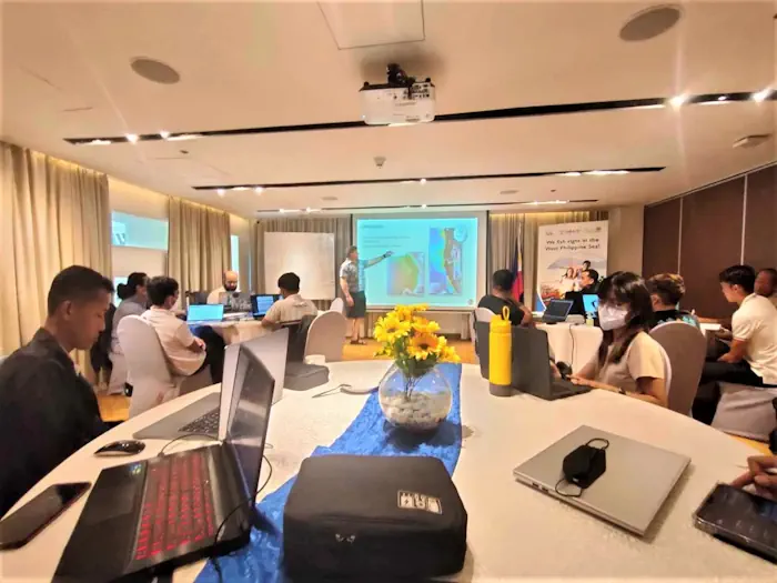
The Palawan Council for Sustainable Development, along with representatives of different government and public organizations dedicated to environmental conservation in Palawan, attended a training-workshop organized by the United States Agency for International Development (USAID) Fish Right program on August 21-23. The workshop consisted of using the features of Google Earth Engine, integrating it with the ...
palawan-news.com
Governo Lança Painel Que Detalha Ocorrências De Desastres Naturais No Rio Grande Do Sul

Governo Lança Painel Que Detalha Ocorrências De Desastres Naturais No Rio Grande Do Sul

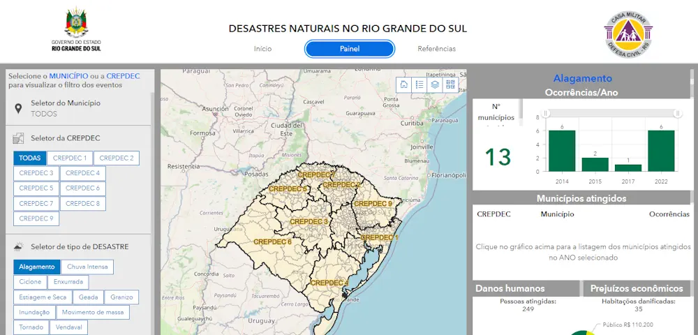
As informações sobre ocorrências de desastres naturais no Rio Grande do Sul entre os anos de 2003 e 2022 foram disponibilizadas pelo governo do Estado em um novo painel, apresentado nesta terça-feira (29/8) durante a 46ª Expointer, em Esteio. No portal, elaborado pela Secretaria de Planejamento, Governança e Gestão (SPGG) em parceria com a Defesa ...
estado.rs.gov.br

Queensland’s Spatial Cadastre Updated For Inland Rail

A two-year project to survey and model nearly 233,000 hectares of land — equivalent to the size of the Australian Capital Territory — to upgrade Queensland’s spatial cadastre, has been completed as a vital part of delivering the Inland Rail project. The spatial cadastre is used to accurately identify the location of the new rail ...
spatialsource.com.au
Esri Canada Launches Assessment Analyst Valueit For Accurate Property Assessment Values

Esri Canada Launches Assessment Analyst Valueit For Accurate Property Assessment Values

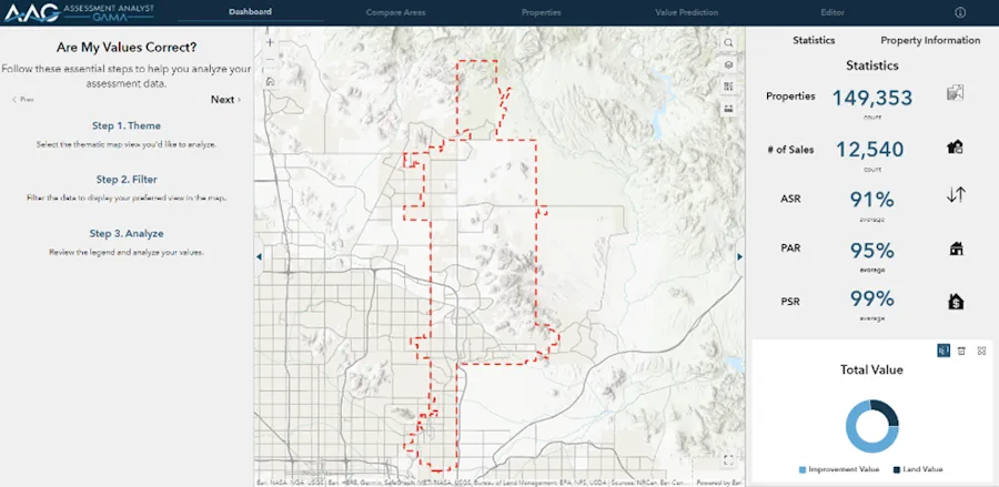
Esri Canada today announced the launch of Assessment Analyst ValueIT, a powerful visualization and analytic application that revolutionizes property assessment by providing clarity and control over the accuracy of assessment values. With AA ValueIT, assessors can confidently determine if assessments meet local or state standards by leveraging the full potential of computer-assisted mass appraisal (CAMA) ...
directionsmag.com

Location Data Can Help Build The EV Chargepoint Network Of Tomorrow

The Geospatial Commission has today (30 August 2023) published a report to support local authorities to make decisions about where to install electric vehicle (EV) chargepoints in their areas. Location data can arm local authorities with evidence to rollout a public charging network that gives current and prospective EV owners the confidence to make their ...
gov.uk
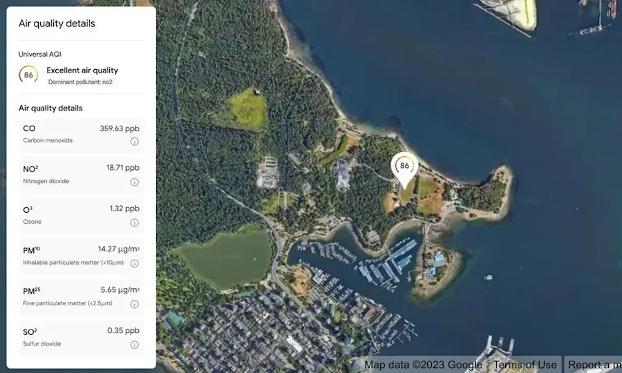
Google Expands Environmental Mapping Tools

Google Expands Environmental Mapping Tools

Google is expanding its sustainability offerings with new products from its Google Maps platform, including mapping technologies for solar energy, air quality, and pollen distribution. The mapping tools use AI and machine learning paired with aerial imagery and environmental data to provide valuable information for developers, businesses, and organizations to track and mitigate their environmental ...
environmentalleader.com