Geomaticians

Geodesy

German Campaign Aims To Get Youngsters Excited About Mapping And Surveying

German Campaign Aims To Get Youngsters Excited About Mapping And Surveying

The German Association for Geodesy (DVW) has launched a campaign to build young people’s awareness of the exciting career opportunities in the geospatial industry. The world of geoinformation is diverse, dynamic, challenging and – most importantly – indispensable in our rapidly changing world. While surveyors and other geospatial professionals are obviously aware of this fact, ...
gim-international.com

Cispa-forscher Christoph Lenzen Erhält Erneut Proof Of Concept Grant Vom ERC

Der aktuelle Mobilfunkstandard 5G sowie das in der Entwicklung befindliche 6G versprechen immens schnelle Datenübertragungsraten und eröffnen damit ganz neue Möglichkeiten. Das in der Informatik altbekannte Problem, große verteilte Netzwerke zeitlich synchron zu halten, sorgt allerdings dafür, dass das volle Potenzial der neuen Technologien kaum ausgeschöpft werden kann. CISPA-Faculty Dr. Christoph Lenzen und sein Team ...
idw-online.de
Entwicklung Neuer Messtechniken In Der Geodäsie

Entwicklung Neuer Messtechniken In Der Geodäsie

Im EU-Forschungsprojekt „Large-scale dimensional measurements for geodesy“ (GeoMetre) entwickelten Forschende der Frankfurt University of Applied Sciences (Frankfurt UAS) und weiterer europäischer Wissenschaftsinstitutionen feldtaugliche Systeme und Analysestrategien zur Verbesserung der Genauigkeit und Rückführbarkeit geodätischer Längenmessungen. Das vom Forschungs- und Innovationsprogramm der Europäischen Union Horizon 2020 (18SIB01) geförderte Projekt verzeichnet schon Erfolge: Die neuen Messinstrumente und -techniken ...
innovations-report.de
Cold Atoms For New Physics

Cold Atoms For New Physics

On 13 and 14 March CERN hosted an international workshop on atom interferometry and the prospects for future large-scale experiments employing this quantum-sensing technique. This quantum sensing technology holds great promise for making ultra-sensitive measurements in fundamental physics. Like light interferometry, atom interferometry involves measuring interference patterns, but between atomic wave packets rather than light ...
cerncourier.com
Bayesian Inversion Used To Recover Geometry Of Ruptured Fault

Bayesian Inversion Used To Recover Geometry Of Ruptured Fault

Large earthquakes generally produce ground deformation that can be measured by geodetic instruments. Geophysicists can use these measurements to invert the earthquake source parameters, that is, to recover the earthquake slip on the ruptured fault. However, the conventional inversion of geodetic data does not fully resolve the geometry of the broken fault at depth. Wei ...
eos.org

OGC Requests Public Comment On A Standardized Deformation Model And A Geodetic Data Grid Exchange Format

The Open Geospatial Consortium (OGC) is requesting public comment on the candidate Deformation Model Functional Model Abstract Specification Topic and the Geodetic data Grid eXchange Format (GGXF) Standard. Comments are due by May 19, 2023. These two Standards seek to improve the accuracy and exchange of coordinate references. The Deformation Model Functional Model is a ...
directionsmag.com

Signing Ceremony Of New Documents Of Cooperation Between Tajikistan And Azerbaijan

Following the meeting and negotiations at the highest level between Tajikistan and Azerbaijan, a ceremony of signing of new documents of cooperation took place. Agreement between the Government of the Republic of Tajikistan and the Government of the Republic of Azerbaijan on cooperation in the field of geodesy, cartography, land surveying, cadastre and remote land ...
einnews.com
Deutschland Verlor In Den Letzten Zwei Jahrzehnten Durchschnittlich 760 Millionen Tonnen Wasser Pro Jahr

Deutschland Verlor In Den Letzten Zwei Jahrzehnten Durchschnittlich 760 Millionen Tonnen Wasser Pro Jahr

Die letzten fünf Jahre in Deutschland waren von massiven Sommerdürren geprägt. Sehr viel Wasser ging verloren. Nur: Wie hoch die Verluste genau waren und ob sich daraus ein Trend für die Zukunft ableiten lässt, sind nach wie vor offene Fragen. Ein Team des Deutschen GeoForschungsZentrums (GFZ) hat nun mit Kolleg:innen die Jahre 2002-2022 genauer untersucht. ...
idw-online.de
Nowa Geodezyjna Ciekawostka Na Wawelu

Nowa Geodezyjna Ciekawostka Na Wawelu

Przy okazji obchodzonego 21 marca Światowego Dnia Geodetów na dziedzińcu Zamku Królewskiego na Wawelu posadowiony został geodezyjny medalion oznaczający symboliczną krakowską oś świata: Axis Mundi Cracoviensis. To już kolejna inicjatywa Mariusza Meusa z akcji „Honorowy Południk Krakowski”, członka Stowarzyszenia Geodetów Polskich. Wśród jego licznych geodezyjnych projektów można wymienić chociażby wyznaczenie współrzędnych geodezyjnego środka Polski oraz ...

La Universidad De Alicante Acoge Un Congreso Internacional Sobre Geodesia

La Sede Universitaria Ciudad de Alicante de la Universidad de Alicante (UA), en su edificio de la calle San Fernando, acogerá desde el 1 al 3 de marzo un congreso internacional de Geodesia. Enmarcado en un grupo de trabajo específico del Servicio Internacional de Rotación terrestre y Sistemas de referencia (IERS), este encuentro recibirá a ...
elperiodic.com
Wasserknappheit In Iran Ist Hausgemacht

Wasserknappheit In Iran Ist Hausgemacht

Forschende des Deutschen GeoForschungsZentrums GFZ haben zusammen mit Kolleg:innen der Universität Stuttgart und des Karlsruher Instituts für Technologie KIT die Entwicklung der letzten zwanzig Jahre für den gesamten Iran nachgezeichnet. Die Studie erschien kürzlich in der Fachzeitschrift Scientific Reports. Das Team nutzte dafür ausschließlich global verfügbare Datensätze, u.a. MODIS-Satellitenzeitreihendaten, Daten der GRACE/-FO-Satellitenmissionen und ERA5-Reanalyse-Klimadaten. Für ...
gfz-potsdam.de

Bilim Insanları Afet Bölgesinin Röntgenini Çekiyor! Belirlenen Noktalara GPS Cihazları Ve Sabit Istasyon Kurulacak

7.7‘lik büyük felaket sonrası TÜBİTAK’ın çağrısıyla afet bölgesine çıkarma yapan bilim insanları, 10 ilin röntgenini çekiyor. Fay hareketlerinin nasıl değiştiğini gözlemleyebilmek amacıyla bölgeye 3 ekibini gönderen Boğaziçi Üniversitesi Kandilli Rasathanesi Jeodezi Anabilim Dalı öğretim üyesi Prof. Dr. Semih Ergintav, “Belirlenen noktalara GPS cihazları ve sabit istasyon kuracağız. Amacımız bundan sonraki nesillere fay hareketliliği ile ilgili ...
sabah.com.tr
Erdbeben In Türkei Und Syrien Hat Gelände Langfristig Verändert

Erdbeben In Türkei Und Syrien Hat Gelände Langfristig Verändert

Nun vermeldet die Europäische Raumfahrtbehörde (ESA), dass die Erdbeben offenbar das Terrain in der Katastrophenregion langfristig verändert haben. So habe sich die Küstenstadt İskenderun stellenweise abgesenkt, was zu Überschwemmungen geführt habe. Zudem drohen in der Region zahlreiche Hänge abzurutschen. Nach dem Beben stellten 17 Weltraumorganisationen insgesamt 350 Satellitenbilder aus der Krisenregion zusammen, damit die Schäden ...
spektrum.de
Grazer Forscher Stellen Schwere Dürre In Europa Fes

Grazer Forscher Stellen Schwere Dürre In Europa Fest

Kernstück des EU-Projekts, von dem die TU Graz wesentlicher Bestandteil ist, sind Zwillingssatelliten namens “Tom und Jerry”. In einer polaren Umlaufbahn in knapp 490 Kilometern Höhe umkreisen die Satelliten die Erde und liefern den Geodätinnen und Geodäten der TU Graz dabei die Daten aus dem Weltall, die sie für die Bemessung des Grundwasserspeichers brauchen. Das ...
meinbezirk.at

Yeraltı Sularının Kullanılması Nedeniyle…

Gümüşhane Üniversitesi Rektörü Prof. Dr. Halil İbrahim Zeybek, Mühendislik ve Doğa Bilimleri Fakültesi Harita Mühendisliği Bölüm Başkanı Doç. Dr. Sefa Yalvaç ile Mühendislik ve Doğa Bilimleri Fakültesi Jeoloji Mühendisliği Bölümü Uygulamalı Jeoloji Kürsüsü Öğretim Üyesi Doç. Dr. Selçuk Alemdağ, zemin çökmelerinin güncel jeodezik tekniklerle izlenmesi ve olası nedenlerinin araştırılmasına yönelik bilimsel çalışma başlattı. Çalışmalar kapsamında ...
torbaliguncel.com

Nowość O Pomiarach Obiektów Naturalnych I Sztucznych

Nakładem Oficyny Wydawniczej Politechniki Wrocławskiej ukazała się książka pt. „Pomiary geometrii w ochronie środowiska, energetyce i górnictwie”. Jej autorem jest dr inż. Tadeusz Głowacki, adiunkt w Katedrze Geodezji i Geoinformatyki PWr. Książka poświęcona jest geodezji: nauce o pomiarach Ziemi, a także obiektów powstałych na jej powierzchni i ich wzajemnym przestrzennym rozmieszczeniu. Uwzględniane są obiekty naturalne ...
geoforum.pl

Gran Canaria Albergará Una Estación De Geodesia Espacial Y Astronomía

El presidente del Cabildo de Gran Canaria, Antonio Morales, ha formalizado este lunes la compra por un precio de 750.00 euros de una finca de 160.043,65 metros cuadrados, ubicada en Temisas, en el municipio de Agüimes, en la que se instalará y se pondrá en funcionamiento una estación de geodesia espacial y astronomía con un ...
eldiario.es
Tsunami Warning Systems Improved Using Signals From Earth’s Ionosphere

Tsunami Warning Systems Improved Using Signals From Earth’s Ionosphere

The study, ‘Spectral Characteristics of Ionospheric Disturbances Over the Southwestern Pacific From the 15 January 2022 Tonga Eruption and Tsunami,’ explores how evidence from the ionosphere explains why the tsunami grew larger and travelled faster than tsunami forecasts predicted. Due to tsunamis being an extremely rare natural disaster, current tsunami warning systems are far from ...
innovationnewsnetwork.com
Kostengünstiger Sensor Erfasst Den Pegel Von Flüssen

Kostengünstiger Sensor Erfasst Den Pegel Von Flüssen

Forschende der Universität Bonn haben ein Verfahren entwickelt, mit dem sich der Wasserstand von Flüssen rund um die Uhr überwachen lässt. Der kostengünstige Sensor eignet sich etwa für flächendeckende Hochwasser-Warnsysteme. Die Studie ist in der Zeitschrift Water Resources Research erschienen. „Kern unseres Geräts ist ein kostengünstiger GNSS-Empfänger“, erklärt Dr. Makan Karegar vom Institut für Geodäsie ...
innovations-report.de
광산구 ‘드론지적 측량’ 시범사업 실시

광산구 ‘드론지적 측량’ 시범사업 실시

광주 광산구(구청장 박병규)는 무인비행장치(드론)를 활용해 지역측지계에서 세계측지계로 변환하는 시범사업을 실시한다고 밝혔다. 이번 항공 드론 촬영 지역은 평동2차산업단지이며 총 403필지 171만8763.6㎡이다. 세계측지계 변환사업은 기존 일본 동경원점을 기준으로 설정된 지역 측지계에서 세계적으로 통용할 수 있는 지구 중심을 원점으로 지역적 오차가 없는 국제 표준 세계측지계로 변환하는 국책사업이다. 광산구 관계자는 “고해상도 드론 항공사진을 활용한 지적측량 시범사업은 지적기준점의 현황을 명확하게 ...
gjdream.com

Warszawa Zmodyfikuje System Geodezyjny Z Wolnej Ręki

Urząd m.st. Warszawy podpisał w trybie z wolnej ręki umowę na świadczenie usług utrzymania i wykonywania modyfikacji systemu do obsługi zasobu geodezyjnego i kartograficznego (System ZGiK). Kontrakt o wartości blisko 2,4 mln zł podpisano z firmą GeoTechnologies z Wrocławia. Dla porównania umowa na budowę i wdrożenie Systemu ZGiK, zawarta z tą spółką w 2017 r., ...
geoforum.pl
Red Argentina De Monitoreo Satelital

Red Argentina De Monitoreo Satelital

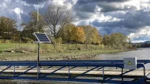
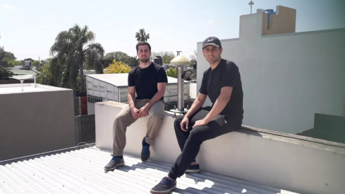
El Colegio de Profesionales de la Agrimensura de Santa Fe (distritos Norte y Sur) impulsa un proyecto que contempla la planificación, distribución, adquisición e instalación de 9 estaciones permanentes sobre el territorio provincial, para ampliar la red argentina de monitoreo satelital continuo. Y la UTN Regional Rafaela, junto al Instituto Geográfico Nacional, colaboran de manera ...
diariolaopinion.com.ar
IFCE Recebe Representante Da Nasa Para Projeto De Cooperação

IFCE Recebe Representante Da Nasa Para Projeto De Cooperação

Instituto Federal do Ceará (IFCE), Nasa, Agência Espacial Brasileira (AEB), Universidade Federal Rural do Semi-árido (Ufersa-RN) e Universidade Mackenzie firmaram acordo para realizar experimentos e projetos conjuntos em nível de pesquisa, desenvolvimento e inovação (PD&I), e em pós-graduação. As ações serão voltadas ao estudo da geodésia do planeta Terra, modelagens do campo gravitacional, radioastronomia, além ...
ifce.edu.br
Alidade and Sons

Alidade & Sons

On this post, I provided the definitions of Alidade, reviewed a timeline of creations of her sons (Groma, Dioptra, Astrolabe, Sextant, and Theodolite), and finally explained how they work.

راه اندازی مرکز کنترل و مدیریت سامانه CORS در دانشکده فنی و مهندسی مرند

در راستای تسهیل دسترسی به داده های سامانه های ماهواره ای ناوبری جهانی (GNSS) و استفاده از آن در کاربردهای علمی پژوهشی، سامانه ایستگاه مرجع دائمی فعال (CORS System) در دانشکده فنی مهندسی مرند راه اندازی شد. دکتر شهامت در ادامه افزود: با راه اندازی این سامانه در حومه شهرستان مرند به فاصله 30 کیلومتر ...
tabrizu.ac.ir
Zapowiedź Kolejnej Edycji Geodezyjnej Olimpiady

Zapowiedź Kolejnej Edycji Geodezyjnej Olimpiady

Komitet Główny Olimpiady Wiedzy Geodezyjnej i Kartograficznej oraz Stowarzyszenie Geodetów Polskich zapraszają uczniów i szkoły do udziału w 45. edycji tego wydarzenia w roku szkolnym 2022/2023. Organizatorem zawodów drugiego i trzeciego stopnia obecnej edycji będzie Zespół Szkół Budowlanych w Bydgoszczy oraz Zarząd Oddziału Stowarzyszenia Geodetów Polskich w Bydgoszczy. Organizatorzy przewidują, że zawody te zostaną przeprowadzone ...
geoforum.pl
The Routledge Handbook of Mapping and Cartography

The Routledge Handbook of Mapping and Cartography

This new Handbook unites cartographic theory and praxis with the principles of cartographic design and their application. It offers a critical appraisal of the current state of the art, science, and technology of map-making in a convenient and well-illustrated guide that will appeal to an international and multi-disciplinary audience. No single-volume work in the field ...
routledge.com
ESA Makes Ground Motion Data Freely Accessible

ESA Makes Ground Motion Data Freely Accessible

thanks to Europe’s environmental Copernicus program and the Sentinel-1 radar satellite mission, the first Europe-wide subsidence and soil movement analysis service is available to the public. The new European Ground Motion Service, the latest offering of the Copernicus Land Monitoring Service and implemented by the European Environment Agency, provides free and accessible ground motion data ...
phys.org