Geomaticians

Forest

NASA Could Help Brazil Monitor Amazon Deforestation

NASA Could Help Brazil Monitor Amazon Deforestation

President Luiz Inácio Lula da Silva on Monday hosted NASA administrator Bill Nelson and U.S. Ambassador Elizabeth Bagley at the presidential palace. According to a statement from the Brazilian government, Mr. Nelson spoke of the possibility of supporting Brazil’s fight against deforestation with the help of new aircraft capable of capturing precise photographs of fires, ...
brazilian.report

New Online ‘Forest Eye’ Will Daylight Old-Growth Logging In B.C.

An online tracking system developed by an international environmental group goes live today. It will enable the public to monitor where old growth is being logged and is designed to hold the province accountable for promises to reform forestry, said project lead Angeline Robertson, a senior investigative researcher with Stand.earth. Forest Eye — an online ...
nationalobserver.com
Un Proyecto Español Permitirá Saber Qué Árboles Plantar En Función Del Cambio Climático

Un Proyecto Español Permitirá Saber Qué Árboles Plantar En Función Del Cambio Climático

El pasado mes de mayo se dio el pistoletazo de salida al proyecto ForesteCCo (FORtaleciendo la RESTauración Ecológica y la infraestructura verde para la adaptación de especies forestales al Cambio ClimáticO). Este proyecto de investigación e innovación se desarrolla con el apoyo de La Fundación Biodiversidad del Ministerio para la Transición Ecológica y el Reto ...
elplural.com

Evaluating Measurement Error In Remote-Sensing Deforestation Data

Remote sensing methods are transformative tools used to study deforestation, but they are by no means perfect. In the new paper “Remotely Incorrect? Accounting for Nonclassical Measurement Error in Satellite Data on Deforestation,” published in the Journal of the Association of Environmental and Resource Economists, authors Jennifer Alix-Garcia and Daniel L. Millimet discuss how errors ...
eurekalert.org

L’observatoire Des Forêts Françaises Est Lancé

Le ministre de l’Agriculture Marc Fesneau et le ministre de la Transition écologique Christophe Béchu lancent l’Observatoire des forêts françaises, afin de rassembler et proposer en un lieu unique les informations indispensables au pilotage des forêts. Cet observatoire a « pour vocation de constituer un centre de partage et de production de données indispensables pour ...
lafranceagricole.fr
Building A Governance Framework For Forest Data In Eastern And Southern Africa

Building A Governance Framework For Forest Data In Eastern And Southern Africa

The East and Southern Africa Forest Observatory (OFESA) was launched at the Global Landscapes Forum (GLF)’s Nairobi conference in late 2018, with twin goals of supporting improved forest monitoring and reporting practices, and developing a data governance framework for the countries in the region. The Observatory’s geoportal, hosted by the Kenya-based Regional Centre for Mapping ...
forestsnews.cifor.org
Mapping Connecticut's Understory From Outer Space

Mapping Connecticut’s Understory From Outer Space

Distinguishing separate plant species from one another is hard even for human eyes; however, a team of UConn researchers was able to use data from a satellite nearly 500 miles (786km) above Earth’s surface to map Connecticut’s forest understory plant communities. The results of this study are published in Remote Sensing of Environment. The understory, ...
phys.org
Laboratório Da UFG Colabora Com Projeto Que Mapeia Biomas E Uso Da Terra Na Indonésia

Laboratório Da UFG Colabora Com Projeto Que Mapeia Biomas E Uso Da Terra Na Indonésia

O Laboratório de Processamento de Imagens e Geoprocessamento (Lapig), da Universidade Federal de Goiás (UFG), por meio do MapBiomas Brasil, recebeu convite para compartilhar conhecimentos e colaborar com o MapBiomas da Indonésia. Para tanto, o Lapig promoveu o treinamento da equipe indonésia no uso dos dados da Rede Global MapBiomas. O encontro durou dez dias, ...
sagresonline.com.br

Digitale Karte Dokumentiert Saure Waldböden

Die Zürcher Wälder sind wie viele andere Gebiete in Mitteleuropa von Bodenversauerung betroffen. Das Amt für Landschaft und Natur hat rund zehn Prozent der Waldböden im Kanton genauer untersucht und die Ergebnisse in einer digitalen Karte dokumentiert. Für die Bewirtschaftung dieser Wälder, gerade angesichts des Klimawandels, wird die Waldbodenkarte wertvolle Zusatzinformationen geben.
zh.ch
Venezuela’s Hidden Runways Bring Both Life And Destruction To Indigenous Lands

Venezuela’s Hidden Runways Bring Both Life And Destruction To Indigenous Lands

Flying over a dense jungle in southern Venezuela, the sea of trees below is suddenly replaced by large patches of bare soil, tree stumps and the turquoise waters of ponds from abandoned gold mines. An airstrip 600 meters long marks the entrance to one of Venezuela’s more than 3,700 gold mines. Only half of the ...
news.mongabay.com
Mapeamento Identifica Conservação De Manguezais Da Grande Reserva Mata Atlântica

Mapeamento Identifica Conservação De Manguezais Da Grande Reserva Mata Atlântica

Pela primeira vez, pesquisadores de diferentes áreas de conhecimento se reúnem para entender como está a saúde dos manguezais na linha de costa, na área conhecida como Grande Reserva Mata Atlântica. A pesquisa envolve trabalho de campo, nos bosques de mangue, e um mapeamento aéreo feito por drones equipados com câmeras altamente tecnológicas e imagens ...

Forest Remote Sensing Faces New Era With 10-cm Satellite Imagery

Scientists from the Aerospace Information Research Institute (AIR), Chinese Academy of Sciences (CAS), have proposed a new algorithm called AGAR, which makes it possible to detect tree heights only using 10-cm stereoscopic imagery, according to a study published in Remote Sensing of Environment on May 10. Current knowledge on the limitation of stereoscopic imagery is ...
miragenews.com
산림청-한국국토정보공사, 산림공간 디지털플랫폼 구현 업무협약 체결

산림청-한국국토정보공사, 산림공간 디지털플랫폼 구현 업무협약 체결

산림청은 이번 업무협약을 계기로 디지털트윈 국토 플랫폼을 활용한 △탄소중립 달성을 위한 디지털 산림 플랫폼 구현 △산림공간 디지털플랫폼 추진전략 기술 지원 △산불·산사태 등 산림재난 대응과 산림 관리를 위한 디지털트윈·확장 가상세계(메타버스) 서비스모델 발굴 및 공동 활용 △디지털트윈 정보 교류·기술 협력·자문 등을 상호 협력해 나갈 예정이다. 또한, 디지털플랫폼 정부 실현 기조에 따라 현행 아날로그 행정체계를 디지털 산림 플랫폼을 ...
boannews.com
Mapping And AI Apps Suggest Ceasing Management Of Forests Not Enough To Offset Carbon Emissions

Mapping And AI Apps Suggest Ceasing Management Of Forests Not Enough To Offset Carbon Emissions

A team of atmospheric and climatic scientists from several institutions in Europe has found that even if all human management of forestry land stopped immediately, it would not be sufficient to offset global carbon emissions. In their study, reported in the journal Science, the group used mapping and AI applications to model how much forest ...
phys.org
Desmatamento Em Terras Públicas Não Destinadas-4 A Área De Estudo

Desmatamento Em Terras Públicas Não Destinadas-4: A Área De Estudo

O estudo foi realizado no distrito de Santo Antônio do Matupi. “Distritos” são unidades administrativas dentro de um município, neste caso o município de Manicoré na porção sul do estado do Amazonas. O distrito de Matupi, também conhecido como “km 180”, está localizado na rodovia Transamazônica (BR-230). Esta estrada principal faz a ligação com o ...
amazoniareal.com.br

Pianificazione Forestale Di Precisione E Tecnologia Lidar

Come ha dimostrato la tempesta Vaia e l’attuale epidemia di bostrico, i cambiamenti climatici possono mettere a dura prova le foreste dell’arco alpino. Anche la programmazione della gestione forestale deve essere affrontata con strumenti al passo con i tempi. In Provincia di Bolzano l’intera superficie forestale viene gestita attraverso strumenti di pianificazione decennali attraverso circa ...
news.provincia.bz.it
A Map Of Every Tree In Africa Will Help Monitor Deforestation

A Map Of Every Tree In Africa Will Help Monitor Deforestation

High-resolution satellite imagery has been used to map every single tree in Africa, demonstrating a technique that could help improve the monitoring of deforestation across the world. Florian Reiner at the University of Copenhagen, Denmark, and his colleagues used images from satellites operated by US firm Planet and machine-learning models to map canopy cover across ...
newscientist.com
Brasil Queimou Área Equivalente A Colômbia E Chile Juntosentre 1985 E 2022

Brasil Queimou Área Equivalente A Colômbia E Chile Juntosentre 1985 E 2022

Um novo mapeamento da superfície queimada pelo fogo no Brasil revela que a área queimada entre 1985 e 2022 foi de 185,7 milhões de hectares, ou 21,8% do território nacional. A média anual alcança 16 milhões de hectares/ano, ou 1,9% do Brasil. São extensões comparáveis a países: no caso do acumulado em 38 anos, a ...
blogdopedlowski.com
Seasonal Effects On Aboveground Biomass Estimation In Mountainous Deciduous Forests

Seasonal Effects On Aboveground Biomass Estimation In Mountainous Deciduous Forests

Researchers from the Aerospace Information Research Institute (AIR) of the Chinese Academy of Sciences (CAS) have found that the proportion of sunlit background visible in remote sensing images controls the vertical distribution of stereoscopic point clouds. The higher the proportion of visible sunlit background, the stronger the ability to detect the understory terrain. The team ...
phys.org

Neue Plattform Beleuchtet Die Bioökonomie

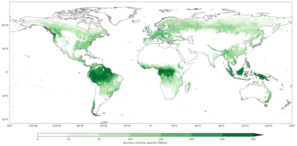
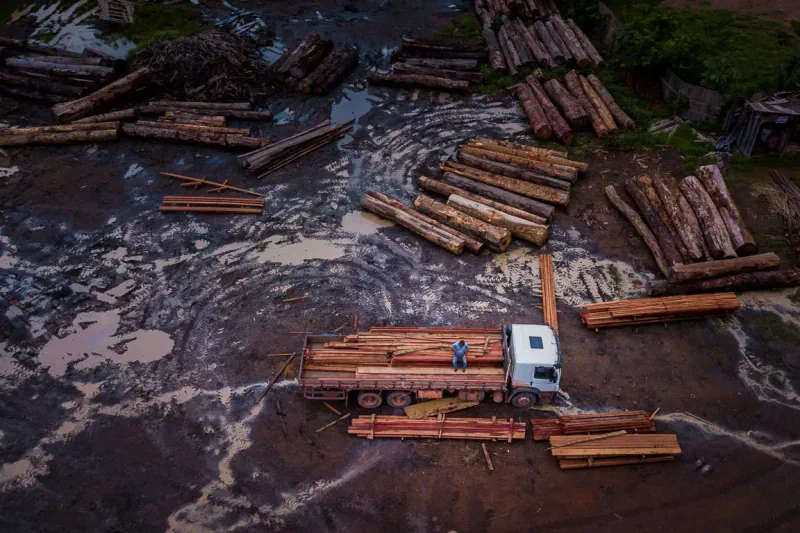
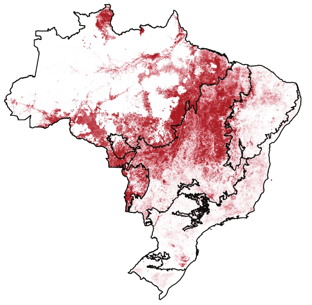
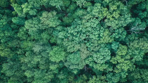
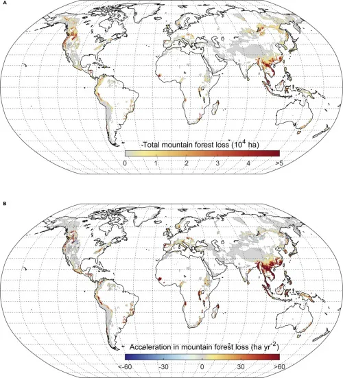
Eine biobasierte Wirtschaft, die sich an natürlichen Kreisläufen orientiert, nachhaltig und klimaneutral ist – das ist das Ziel der Bioökonomiestrategie der Bundesregierung. Doch entwickelt sich die Bioökonomie in allen Bereichen in die gewünschte Richtung? Die Nutzung von Biomasse kann zu Zielkonflikten führen, die nicht immer auf den ersten Blick sichtbar sind, weil sie global oder ...
idw-online.de
Study Shows Mountain Forests Being Lost At ‘Alarming Rate,’ Especially In Asia

Study Shows Mountain Forests Being Lost At ‘Alarming Rate,’ Especially In Asia

More than 7% of all mountain forests have been destroyed during the past two decades, according to a new study published in the journal One Earth. Using high-resolution satellite data and maps of mountain terrains, researchers found that 780,000 square kilometers (301,000 square miles) of mountain forest were lost worldwide between 2001 and 2018. The ...
news.mongabay.com
Terras Indígenas Na Amazônia Brasileira Ajudam A Prevenir Doenças Causadas Por Queimadas, Diz Estudo

Terras Indígenas Na Amazônia Brasileira Ajudam A Prevenir Doenças Causadas Por Queimadas, Diz Estudo

Novo estudo de dez anos, revisado por pares, sugere que as florestas administradas por Indígenas na Amazônia Brasileira absorvem milhares de poluentes de gases venenosos provenientes de incêndios florestais, evitando 15 milhões de dispendiosos casos de doenças todos os anos. Com base em uma análise de dados de dez anos, os autores do novo estudo ...
blogdopedlowski.com
This UC Doctoral Student Is Helping Pileated Woodpeckers Find Space In Hamilton County

This UC Doctoral Student Is Helping Pileated Woodpeckers Find Space In Hamilton County

As cities continue expanding, forested areas are becoming scarcer, and less dense. That’s bad news for the wildlife that call those areas home. A University of Cincinnati doctoral student is studying what local areas are important to North America’s largest woodpecker. “The pileated woodpecker is not considered as a vulnerable species, but it is an ...
wvxu.org
Türkiye Maps Northwestern Forest Migration Amid Climate Change

Türkiye Maps Northwestern Forest Migration Amid Climate Change

Türkiye on Friday released a map of the projected distribution of trees and the migration of forests around the country’s internal Marmara Sea until the end of this century. The initiative was part of a project carried out to explore the potential of the northwestern forests in the Marmara region to adapt to climate change. ...
aa.com.tr
Brazil Evicts Gold Miners From Amazon Rainforest

Brazil Evicts Gold Miners From Amazon Rainforest

Brazil has ousted almost all illegal gold miners from the Yanomami territory, its largest indigenous reservation, and will remove miners from six more reserves this year, the head of the federal police’s new environmental crimes division said on Tuesday. Enforcement operations supported by satellite imagery and aerial photography have destroyed 250 miner camps – many ...
climatechangenews.com
National Forest Maps Of Germany Based On Current Satellite Imagery And Terrestrial Data

National Forest Maps Of Germany Based On Current Satellite Imagery And Terrestrial Data

The Thünen Institute now offers interactive forest maps through the Thünen Atlas (http://atlas.thuenen.de) that provide a nationwide overview of the stocked forest area—i.e., the area on which trees grow—and the dominant tree species. The digital maps have a resolution of 10m x 10m. The map of dominant tree species is based on data from the ...
phys.org

Alunos Da UFMG Criam Solução Para Detectar E Emitir Alertas De Desmatamento

Um grupo de alunos do Programa de Pós-graduação em Análise e Modelagem de Sistemas Ambientais, do Instituto de Geociência da Universidade Federal de Minas Gerais (IGC/UFMG), desenvolveu um programa capaz de detectar e emitir alertas de desmatamento usando, entre outras coisas, inteligência artificial e imagens de satélite. Chamado de TerraChange, a plataforma é um produto ...
em.com.br

Tracking Land Use And Deforestation In The Amazon

Scientists monitoring the region via satellite found that between 2000 and 2021, the average deforestation rate in nonprotected areas was about 14 times higher than in protected areas and Indigenous lands. The research contributes to an ongoing conversation about conservation of the Amazon, said study lead author Yuanwei Qin, a research scientist at the University ...
eos.org

Drones E Modelagem 3D Auxiliarão A Recuperação De Florestas

A popularização dos drones comerciais, das inteligências artificiais e dos softwares de modelagem 3D permitiram o desenvolvimento de um novo método para controlar áreas de reflorestamento. Durante seu doutorado no Instituto de Energia e Ambiente (IEE) da USP, o engenheiro florestal e pesquisador Rafael Walter de Albuquerque criou um procedimento mais rápido e capaz de ...
Phone-based Measurements Provide Fast, Accurate Information About The Health Of Forests

Phone-based Measurements Provide Fast, Accurate Information About The Health Of Forests

The researchers, from the University of Cambridge, developed the algorithm, which gives an accurate measurement of tree diameter, an important measurement used by scientists to monitor forest health and levels of carbon sequestration. “When you’re trying to figure out how much carbon a forest is sequestering, these ground-based measurements are hugely valuable, but also time-consuming,” ...
eurekalert.org