Geomaticians

Energy

Inside The Department Of Energy Project Using Drones To Map Radioactive Waste Storage Vaults

Flyability’s Elios 3 has successfully completed a 3D mapping operation of a radioactive waste storage vault following more than a year of preparation and research. The information obtained in the mapping project will prove crucial to planning the vault’s removal. This is thought to be the first time a drone has been deployed to enter ...
dronelife.com

European Space Agency Backs Geospatial Project To Protect Utilities

MGISS, a UK geospatial company, aims to understand how satellite imagery can identify areas where developments could disrupt gas and water supply. The Interruption Prevention Alert Service project will use satellite data and services to automatically detect changes to the built environment in order to prevent outages in critical utilities. The company argued that a ...
placetech.net

A New Tool Helps Map Out Where To Develop Clean Energy Infrastructure

The Geospatial Energy Mapper (GEM) is a comprehensive, interactive online mapping tool that can help identify areas across the country that are suitable for wind, solar and more. First publicly launched in 2013 as the Energy Zones Mapping Tool (EZMT), GEM has been redesigned, rebranded and reengineered. GEM is hosted by the U.S. Department of ...
sciencedaily.com
Mapa De Calor En España

Mapa De Calor En España

El Instituto para la Diversificación y el Ahorro de la Energía (IDAE), entidad adscrita al Ministerio para la Transición Ecológica y el Reto Demográfico (MITECO), ha publicado el mapa de calor de España. El mapa impulsará los proyectos de calefacción y refrigeración eficientes, desde el momento en que permite identificar las demandas térmicas de todos ...
tiempo.com
GIS Energy Map For Resource And Infra Planning

GIS Energy Map For Resource And Infra Planning

The Geospatial Energy Map of India by the NITI Aayog, in collaboration with ISRO, identifies and locates all primary and secondary sources of energy along with their transportation and transmission networks. The idea is to develop a web-GIS-based information system for the visualisation of spatial and non-spatial data associated with conventional energy sources in India ...
geospatialworld.net
Kieler Forschende Bauen Für Stadt Einmaliges 3-d-energiemodell - Um Sparpotential Aufzuzeigen

Kieler Forschende Bauen Für Stadt Einmaliges 3-d-energiemodell – Um Sparpotential Aufzuzeigen

Angesichts der aktuell befürchteten Energieknappheit im Wärmesektor diskutieren Politik, Wirtschaft und Gesellschaft intensiv über den Heizenergiebedarf und mögliche Einsparmaßnahmen für Industrie, Gewerbe und private Haushalte. Grundlage dafür ist eine belastbare Datenbasis. Genau daran arbeiten jetzt Forschende der Christian-Albrechts-Universität zu Kiel (CAU) zusammen mit dem global tätigen Energie-Unternehmen Shell. Unterstützt werden sie dabei von dem Klimaschutzmanagement ...
uni-kiel.de

Mapa Powie, Czy Warto Inwestować W Pompę Ciepła

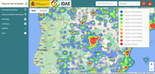
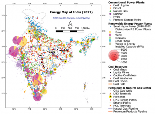
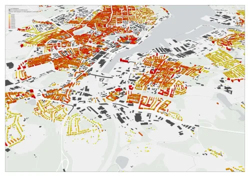
To, że technologie GIS-owe wspierają wykorzystanie alternatywnych źródeł energii, nie jest niczym nowym. W ostatnich latach powszechne stały się bowiem różnorodne lokalne serwisy mapowe prezentujące potencjał solarny budynków. Dzięki nim właściciel nieruchomości może łatwo sprawdzić, czy opłaca mu się instalować panele fotowoltaiczne, a bardziej szczegółowe serwisy wskazują nawet konkretne fragmenty dachu najlepiej nadające się do ...
geoforum.pl

This Atlas Wants To Map Every Solar And Wind Source In Your Country

It’s easy to spot a wind turbine or solar array from the window of your car, but counting each installation across the world is quite a different story. And since neither the Paris Agreement nor the United Nations Sustainable Development Goals can possibly be fulfilled without a broad adoption of renewable energy sources, having a ...
planet.com

Castelló Desarrolla Un ‘Mapa Solar’ De Los Tejados Para Promover Un Plan De Autoconsumo De Fotovoltaicas En Los Edificios

La Concejalía de Transición Ecológica del Ayuntamiento de Castelló de la Plana ha contratado un nuevo servicio que se encargará en los próximos meses de desarrollar un ‘mapa solar’ del término municipal que informe del potencial de las cubiertas para la instalación de placas fotovoltaicas y acelerar el autoconsumo en los edificios de la ciudad. ...
eldiario.es

Using Satellite Images, Scholars Develop A Model To Quantify Buildings’ Energy Use

In the face of climate change, reducing buildings’ energy consumption is critical, says Thomas Dougherty, a graduate student in civil and environmental engineering at Stanford University. By some estimates, buildings account for about 40% of the energy used in the United States. Reducing that usage in a significant way will require a comprehensive, holistic approach. ...
hai.stanford.edu