Geomaticians

DLR

DLR Develops Mobile Station For Satellite Laser Ranging

DLR Develops Mobile Station For Satellite Laser Ranging

Satellite Laser Ranging (SLR) is a very precise, laser-based method for determining the distance between a satellite and Earth with an accuracy of a few millimetres. SLR is primarily used in geodesy. This is because the precise measurement of satellite orbits helps to determine changes in Earth’s structure and rotation. The SLR method also makes ...
spacedaily.com
Satellites Detect Where Locust Infestations Begin

Satellites Detect Where Locust Infestations Begin

Locusts can destroy grain crops and pastures, threatening people’s livelihoods. In an international project, researchers from the German Aerospace Center (Deutsches Zentrum für Luft- und Raumfahrt; DLR) have now developed methods to help detect locust outbreaks as early as possible and take action against them. Earth observation images acquired by satellites play a central role ...
dlr.de
EUSI Invests In Ground Station Upgrade At The German Aerospace Center (DLR) For The Fastest VHR Satellite Imagery Delivery In Europe

EUSI Invests In Ground Station Upgrade At The German Aerospace Center (DLR) For The Fastest VHR Satellite Imagery Delivery In Europe

European Space Imaging (EUSI), the leading provider of Very High Resolution (VHR) satellite imagery in Europe, is thrilled to announce a multi-million euro investment into their ground station located at the German Aerospace Center (DLR) near Munich. This strategic upgrade extends the ability for EUSI to deliver imagery with unprecedented speed and efficiency, solidifying its ...
directionsmag.com

Terrabyte: Germany’s New High Performance Data Analytics Platform For Earth Observation

A new high performance data analytics platform called terrabyte has been announced that will enable researchers in Bavaria and Germany to use satellite and earth observation data for classical simulations and evaluation using artificial intelligence methods. The new system is jointly run by the German Aerospace Center (DLR), a national research center for aeronautics and ...
datanami.com
Galileo’s Next Ride Moving Towards Operational Status

Galileo’s Next Ride Moving Towards Operational Status

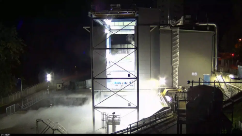
ESA’s Ariane 6 launch vehicle, on which the deployment of the EU’s Galileo GNSS satellite constellation now depends, has taken another step towards first flight. A fresh series of hot fire tests of the rocket’s upper stage and all-new Vinci engine is now underway at Germany’s DLR center for engine and stage testing in Lampoldshausen. ...
insidegnss.com

Czy Beidou Przyniesie Przełom W Realizacji Ziemskich Układów Odniesienia?

Zespół naukowców z Uniwersytetu Przyrodniczego we Wrocławiu (Radosław Zajdel) i Niemieckiej Agencji Kosmicznej DLR (Peter Steigenberger oraz Oliver Montenbruck) opublikował właśnie pracę, w której przeprowadzono ocenę potencjalnego wykorzystania chińskiej konstelacji BeiDou trzeciej generacji (BDS-3) z satelitami na średniej orbicie okołoziemskiej (MEO) do realizacji skali ziemskich układów odniesienia.
geoforum.pl