Geomaticians

Climate Change

Airborne Surveys Launched In Chile To Detect Sources Of Methan

Airborne Surveys Launched In Chile To Detect Sources Of Methane

Airborne surveys have been launched in Chile to detect sources of methane by Carbon Mapper, a California based nonprofit. This survey aims to point sources that potentially emit disproportionately high volumes of methane and therefore offer important mitigation opportunities. This survey kicks off a broader initiative to conduct airborne methane surveys in the Latin American ...
geospatialworld.net
How Climate Change Is Impacting Galleries, Libraries, Archives And Museums

How Climate Change Is Impacting Galleries, Libraries, Archives And Museums

To further understand the impact of climate change on these cultural and information repositories, the Institute of Museum and Library Services based in Washington, D.C. has awarded a grant to LSU School of Library & Information Science Associate Professor Edward Benoit III and LSU Department of Geography & Anthropology Associate Professor Jill Trepanier with collaborator ...
lsu.edu
Esri India Launches Carbon Footprint Awareness App

Esri India Launches Carbon Footprint Awareness App

Leading Geographic Information System (GIS) solutions provider Esri India announced on Tuesday the launch of an app in Hindi and English to enhance awareness about carbon footprint at an individual level. A simple to use app ‘Carbon Jagruk’ or ‘CarbonAware’ enables citizens to estimate and reduce their carbon footprint requires no login or download and ...
deccanchronicle.com

Au Rwanda, Un Nouvel Outil Cartographie La Teneur En CO2 Des Arbres

On connaît l’importance des écosystèmes forestiers pour séquestrer le carbone et lutter contre le dérèglement climatique. Mais la quantité de dioxyde de carbone que les arbres peuvent absorber reste difficile à évaluer de manière précise, ce qui entrave l’efficacité de mesures concrètes visant à limiter le réchauffement de la planète. Des chercheurs de l’université de ...
rtbf.be

Coclico, El Proyecto Europeo Que Analiza Riesgos Costeros E Implementa Medidas De Adaptación Más Eficientes Y Sostenibles

IHCantabria, junto a otras diecisiete instituciones socias como Deltares (Países Bajos), Sayers and partners LLP (Reino Unido) o el Global Climate Forum EV (Alemania), está desarrollando el proyecto Coastal Climate Core Service (CoCliCo) financiado por la Comisión Europea en la convocatoria H2020 cuya duración se extenderá hasta 2026. La finalidad del proyecto, liderado por BRGM ...
web.unican.es

The First Complete Picture Of Arctic Sea Ice Freeze-thaw Cycle Highlights Sea Ice Response To Climate Change

Years of research show that climate change signals are amplified in the Arctic, and that sea ice in this region is sensitive to increases in Arctic warming. Sea ice greatly modifies the exchanges of heat, momentum and mass between the atmosphere and the ocean. So, the timings of the sea ice melt and freeze onsets, ...
eurekalert.org
The Satellite Data Mapping Australia's New Climate Extremes

The Satellite Data Mapping Australia’s New Climate Extremes

For decades, satellites have been keeping a watchful eye on Earth, relaying increasingly precise, detailed and timelier information than ever before. Armed with the right mathematical tools, we can use this information to anticipate and mitigate climate extremes and associated hazards—from floods to landslides. So why isn’t this happening now? To harness its full potential, ...
phys.org

High-res Maps Of Entire Polar Regions Provide New Clues For Climate Researchers

A team of researchers led by the University of Minnesota Twin Cities has released four more years of high-resolution imagery data, which has been added to eight years of previous data, to create the most detailed polar region terrain maps ever created. The maps use high-resolution satellite data to show the polar regions in stunning ...
newswise.com

Mapping The Pressures Of Global Food Production

A map showing the environmental pressures from global food production has been developed by researchers, to identify ways of creating more sustainable and just food systems. The analysis looked at greenhouse gas emissions, water use, habitat disturbance and pollution, such as effluent or fertiliser run off from farms. The study, by the University of Leeds ...
leeds.ac.uk
NASA, USGS Map Minerals To Understand Earth Makeup, Climate Change

NASA, USGS Map Minerals To Understand Earth Makeup, Climate Change

NASA and the U.S. Geological Survey (USGS) will map portions of the southwest United States for critical minerals using advanced airborne imaging. Hyperspectral data from hundreds of wavelengths of reflected light can provide new information about Earth’s surface and atmosphere to help scientists understand Earth’s geology and biology, as well as the effects of climate ...
nasa.gov
Climap Una Mappa Partecipata Degli Eventi Climatici Estremi

Climap: Una Mappa Partecipata Degli Eventi Climatici Estremi

Una mappatura partecipata di tutti gli eventi meteo estremi che colpiscono il nostro Paese. Questo l’obiettivo di CLIMap, progetto di gisAction e Legambiente che vuole accendere i riflettori sul rischio climatico e sulla crisi climatica a partire dall’esperienza del singolo cittadino. Ogni utente potrà quindi segnalare l’evento climatico estremo che lo ha colpito e quali ...
ilgiornaledellaprotezionecivile.it
New Mapping Tool To Support The Search For High-quality Nature-based Carbon Credits

New Mapping Tool To Support The Search For High-quality Nature-based Carbon Credits

An interactive mapping software that will support the prospecting, development and management of nature-based carbon credit projects worldwide was launched on 22 September at the World Economic Forum – Champions for Nature event in New York during Climate Week NYC 2022. The open-access platform (http://carbonprospecting.org), dubbed the Carbon Prospecting Dashboard, was jointly developed by the ...
newswise.com
Climate Change Is Making Lakes Less Blue

Climate Change Is Making Lakes Less Blue

If global warming persists, blue lakes worldwide are at risk of turning green-brown, according to a new study which presents the first global inventory of lake color. Shifts in lake water color can indicate a loss of ecosystem health. While substances such as algae and sediments can affect the color of lakes, the new study ...
eurekalert.org

Using Satellite Images, Scholars Develop A Model To Quantify Buildings’ Energy Use

In the face of climate change, reducing buildings’ energy consumption is critical, says Thomas Dougherty, a graduate student in civil and environmental engineering at Stanford University. By some estimates, buildings account for about 40% of the energy used in the United States. Reducing that usage in a significant way will require a comprehensive, holistic approach. ...
hai.stanford.edu

SLU, NGA to host annual Geo-Resolution Conference focusing on climate change

The National Geospatial-Intelligence Agency (NGA) and Saint Louis University (SLU) will co-host the annual Geo-Resolution conference Wednesday, Sept. 28, at SLU. Geo- Resolution is an annual conference that encourages collaboration between government, academic and industry partners to foster geospatial technology innovation and applications, connect geospatial experts and students, and grow the geospatial ecosystem in the ...
newswise.com

Biden Administration Launches Portal To Help Communities Assess Exposure To Climate Hazards

Today, the Biden-Harris Administration in partnership with Department of Commerce’s National Oceanic and Atmospheric Administration (NOAA) and the Department of the Interior (DOI) jointly launched a new website to help communities across the nation understand the real-time climate-related hazards in their area, analyze projected long-term exposure to those hazards, and identify federal funds to support ...
noaa.gov

Mapping US Coastlines May ‘Drive More Equality’ In Climate Adaptation Policy

A Canadian technology company is using aerial imagery to build high-precision maps of US shorelines that will be used to help coastal communities adapt to climate change. By cataloguing which neighborhoods have more impervious surfaces like sidewalks and driveways compared to permeable ground with vegetation and trees, policymakers can better predict where heat waves or ...
financialpost.com

New Classification Of The World’s Coastlines To Improve Climate Action

A new classification of the world’s coastlines has been released to improve coastal climate change adaptation at local, regional and national level and strengthen coordinated climate action worldwide. The classification builds on the Coastal Hazard Wheel that is a universal coastal management framework and is developed by the Coastal Hazard Wheel initiative involving Deltares, the ...
Remote Sensing Helps In Monitoring Arctic Vegetation For Climate Clue

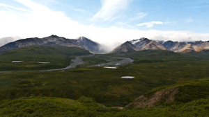
Remote Sensing Helps In Monitoring Arctic Vegetation For Climate Clues

Monitoring vegetation shifts in the Arctic can help scientists understand how the area is changing as the world warms. Already, researchers have documented expansion of boreal forests into the tundra. And at many sites in the region, the tundra is greening up, according to recent satellite observations. NASA postdoctoral fellow Andy Maguire says these vegetation ...
yaleclimateconnections.org
Biden Administration Launches Heat.Gov With Tools For Communities Facing Extreme Heat

Biden Administration Launches Heat.Gov With Tools For Communities Facing Extreme Heat

Today, the Biden Administration through the interagency National Integrated Heat Health Information System (NIHHIS) launched Heat.gov, a new website to provide the public and decision-makers with clear, timely and science-based information to understand and reduce the health risks of extreme heat. Heat.gov will provide a one-stop hub on heat and health for the nation and ...
noaa.gov
The Impacts Of Climate Change, Population Growth And Land-use Change On Protected Areas In Africa

The Impacts Of Climate Change, Population Growth And Land-use Change On Protected Areas In Africa

Ph.D. student Carola Martens together with other researchers from Senckenberg and South Africa’s Stellenbosch University has investigated how climate change could affect vegetation in protected areas in Africa. In their study, which was published in the journal Conservation Biology, the team shows where these effects may coincide with population growth and land use changes. According ...
phys.org

Geospatial, Mapping Central US Govt Climate Action: Top White House Aide

The US government is working on building a climate resilience portal that seeks to bring together all valuable information on climate change and its impacts under one umbrella. David J. Hayes, Special Assistant to the US President for Climate Policy, revealed this at Esri User Conference 2022 underway at San Diego.
geospatialworld.net
Study Reveals High Mountain Asia Hydropower Systems Are Threatened By Climate Change

Study Reveals High Mountain Asia Hydropower Systems Are Threatened By Climate Change

The Himalayas and neighboring mountain ranges (or High Mountain Asia), the planet’s most extensive icy systems outside the polar regions, have the world’s largest undeveloped hydropower potential and are seeing numerous dams and reservoirs under construction or planning. However, climate change is destabilizing the landscapes and threatening numerous hydropower projects according to a new study ...
phys.org
New Interactive Climate Map Shows Impact Of Heat, Flooding In Fairfax County

New Interactive Climate Map Shows Impact Of Heat, Flooding In Fairfax County

As Fairfax County finalizes its first-ever plan to address the future effects of climate change, community members can see how the phenomenon already affects them with a newly released interactive map. Launched last week, the climate map depicts heat and flooding data that can be viewed in conjunction with maps of the county’s population and ...
ffxnow.com