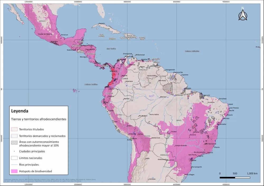
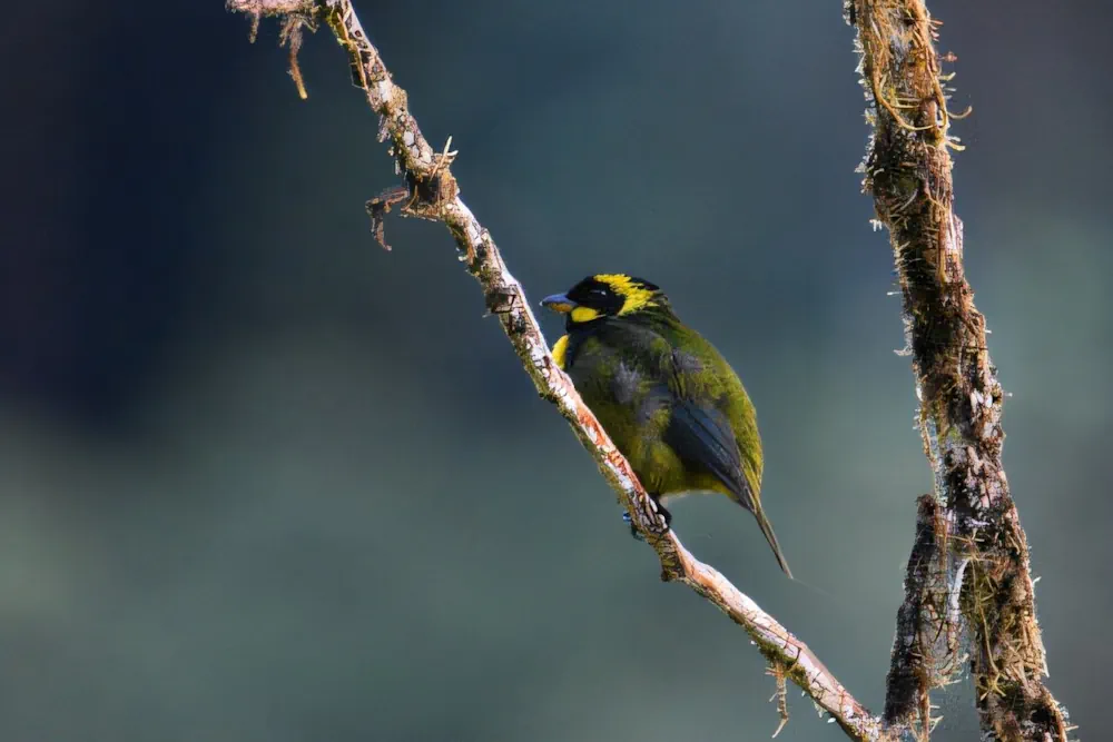
Geomaticians

Biogeography

University Of Nevada, Reno Team Develops New Vegetation Mapping Tools

University Of Nevada, Reno Team Develops New Vegetation Mapping Tools

Powerful new digital mapping tools developed by University of Nevada, Reno researchers hold promise to improve management of rangeland, particularly public lands in the far-flung Western United States. The significant improvements in mapping of vegetation enabled by the University’s research provide managers of rangeland, ranchers as well as federal managers of public lands, with better ...
unr.edu
Remote Sensing Research Unravels Plant Genetic Diversity And Evolution

Remote Sensing Research Unravels Plant Genetic Diversity And Evolution

A research team has recently published a comprehensive review on the innovative integration of spectral data and phylogeographic patterns to study plant genetic variation. The findings demonstrate the effectiveness of remote sensing technology in identifying and analyzing genetic variations in plants across different geographical regions. This methodology not only deepens our understanding of plant diversity ...
phys.org
Chornobyl Reserve Unveils New Online Mapping Portal Providing In-Depth Insights Into Exclusion Zone

Chornobyl Reserve Unveils New Online Mapping Portal Providing In-Depth Insights Into Exclusion Zone

The Chornobyl Radiation-Ecological Biosphere Reserve has launched a geoportal with information on 38 years of activity of various departments on the territory of the exclusion zone: from research and education to accounting for land, forest and water resources, reported the Chornobyl Reserve. “Here you will find a map of modern, anthropogenic landscapes of the territory, ...
life.liga.net
Satellites Track The Tiny Silver Fish Hugely Important To Marine Life

Satellites Track The Tiny Silver Fish Hugely Important To Marine Life

A new scientific endeavour has taken to the sky using high-tech drones and satellite images to understand better the annual spring herring spawn vital to salmon and wildlife on the West Coast. Between February and March each year, frigid ocean waters transform to a milky tropical-looking turquoise green when male herring release milt to fertilize ...
nationalobserver.com
New Mapping Method Developed For Critical Marine Habitat

New Mapping Method Developed For Critical Marine Habitat

Researchers at The University of Western Australia have led the development of a new technique for accurately mapping shallow and coastal marine habitats. Dr Sharyn Hickey and Dr Stan Mastrantonis, from UWA’s School of Agriculture and Environment, School of Biological Sciences and Oceans Institute, were co-authors of the research published in the ISPRS Journal of ...
uwa.edu.au

Philsa, DENR Team Up To Create Mangrove Map Using Satellite Data

The Philippine Space Agency (PhilSA) and the Department of Environment and Natural Resources (DENR) have collaborated to develop a nationwide mangrove map using remote sensing data, a vital tool for conservation efforts. The mangrove mapping initiative is part of the DENR’s development of a national geospatial database for its environment and natural resource accounting program. ...
philstar.com

Al Via La Prima Mappa Delle Coste Italiane

Il progetto MER è la prima campagna di monitoraggio delle coste dell’Italia. L’intento è fornire dati ad altissima risoluzione volti a migliorare il processo decisionale dei governi locali per la protezione degli habitat e delle specie marine di interesse conservazionistico. A gestire il bando l’ISPRA che ha assegnato al consorzio guidato da Fugro l’azione di ...
canaleenergia.com

برای نخستین بار؛ نقشه پراکنش گونه‌های شاخص حیات‌وحش تهیه می‌شود

حسن اکبری، معاون محیط زیست طبیعی و تنوع زیستی سازمان حفاظت محیط‌زیست گفت: برای نخستین بار نقشه پراکنش ۱۹ گونه جانوری شاخص حیات‌وحش کشور تهیه می‌شود که تاکنون ۵۰ درصد کار پیشرفت داشته است. جغرافیای وسیع و گسترده ایران گونه‌های جانوری زیادی را در خود جای داده است و در هر گوشه و کنار کشور ...
irna.ir
Mapeamento De Cabo Verde Para Proteger As Tartarugas Do Plástico

Mapeamento De Cabo Verde Para Proteger As Tartarugas Do Plástico

A estudante do Programa Doutoral em Biologia da FCUP, Diana Sousa Guedes, tem estado a mapear, com recurso a um drone, o lixo marinho das praias de Cabo Verde, num trabalho que procura perceber o impacto do plástico nas tartarugas-marinhas. O objectivo é proteger estas espécies ameaçadas de extinção, num cenário cujos resultados não são, ...
campeaoprovincias.pt
Projeto Biogeomar Convida O Público A Fotografar Animais E Plantas Marinhos

Projeto Biogeomar Convida O Público A Fotografar Animais E Plantas Marinhos

Onde estão as espécies do litoral brasileiro? Buscando conhecer melhor a biodiversidade marinha brasileira, o Programa BioGeoMar acaba de lançar a campanha de ciência cidadã BioBlitz Verão 2024. Nela, o público é convidado a explorar, identificar e registrar a vida dentro e fora da água, sejam animais ou plantas, encontrados em praias, mergulhos ou em ...
ufpr.br
Progress In High-Resolution Vegetation Mapping China's Leap Toward Advanced Environmental Monitoring

Progress In High-Resolution Vegetation Mapping: China’s Leap Toward Advanced Environmental Monitoring

For a study published in the Journal of Remote Sensing, a team of scientists led by Xihan Mu from Beijing Normal University has made a leap forward in environmental monitoring and ecological research. They have created seamless maps of Fractional Vegetation Cover (FVC) over China at 30-meter resolution and semimonthly intervals, covering the years 2010-2020. ...
phys.org
Newly Released Avian Data Monitoring Portal Available To Public And Researchers

Newly Released Avian Data Monitoring Portal Available To Public And Researchers

A newly released Avian Data Monitoring Portal brings together more than a decade of aerial survey photos along the northern Gulf of Mexico to provide an easily searchable database for researchers, natural resource managers, and the public. Found at avianmonitoring.com, the portal will help coastal managers, coastal restoration engineers, researchers, and others not only see ...
press-herald.com
New Research Reveals That Only 18 Percent Of Land Critical For Both Human Well-Being And Biodiversity Is Protected

New Research Reveals That Only 18 Percent Of Land Critical For Both Human Well-Being And Biodiversity Is Protected

A new study supported by One Earth and published in Nature Communications sheds light on a critical environmental issue: the balance between human well-being and biodiversity conservation. The research, conducted by an international team of researchers, reveals that conserving approximately half of the global land area is essential to maintain the majority of nature’s contributions ...
oneearth.org
The Sound Maps That Predict Poachers' Movements

The Sound Maps That Predict Poachers’ Movements

In the Upper Paraná Atlantic Forest lies the world-renowned Iguazu Falls. On one side of the towering cascades is the Iguazú National Park of Argentina, on the other is the Iguaçu National Park of Brazil. Greened by over 2,000 plant species, the landscape is home to an array of creatures, including the charismatic jaguar. And ...
bbc.com

Croatia’s National Map Of Maritime Habitats Launched

This marked the culmination of the project “Mapping Coastal and Submarine Habitats in the Adriatic Sea under National Jurisdiction,” spearheaded by the Ministry of Economy and Sustainable Development of the Republic of Croatia (MINGOR) in collaboration with a consortium of over 200 experts. Institute of Oceanography and Fisheries said that the project aimed to enhance ...
croatiaweek.com
How Artificial Intelligence Can Help Beavers Fight Floods, Droughts And Wildfires

How Artificial Intelligence Can Help Beavers Fight Floods, Droughts And Wildfires

A few years ago, a couple of Google employees reached out to a Minnesota scientist with an unusual proposal: What if they could teach computers to spot beaver habitats from space? “They wanted to know if I thought it was possible to find beaver wetlands from aerial imagery myself, and then if that could be ...
cbc.ca
Restoring Ecosystems To Boost Biodiversity Is An Urgent Priority – Our ‘Eco-index’ Can Guide The Way

Restoring Ecosystems To Boost Biodiversity Is An Urgent Priority – Our ‘Eco-index’ Can Guide The Way

Biodiversity continues to decline globally, but nowhere is the loss more pronounced than in Aotearoa New Zealand, which has the highest proportion of threatened indigenous species in the world. Planning large-scale biodiversity restoration projects – whether they’re run by NGOs, governments or Indigenous groups – requires high-quality data. Despite the rising demand, however, accessible biodiversity ...
theconversation.com
A Database Unifies The Information On Damage To European Forests Over The Last 60 Years

A Database Unifies The Information On Damage To European Forests Over The Last 60 Years

The University of Córdoba is participating in the creation of the first database that harmonizes the recording of disturbances caused by insects and diseases in forests in 8 European countries by combining remote sensing, satellite images and field data. Forest damage caused by insects and diseases is increasing in many parts of the world due ...
eurekalert.org
UB, NASA And Partners Begin Mapping South Africa’s Biodiversity From The Air

UB, NASA And Partners Begin Mapping South Africa’s Biodiversity From The Air

Over the next few weeks, NASA aircraft will fly over South Africa’s Greater Cape Floristic Region and collect ultraviolet, visual, thermal and other imagery of its terrestrial and aquatic ecosystems. These preliminary images will be publicly available and posted online here within hours of the aircraft landing each day. Combined with satellite imagery and field ...
buffalo.edu
Seminario Revelará Proyecto Que Utiliza Sensores Remotos Para Impulsar La Apicultura Natural Regenerativa

Seminario Revelará Proyecto Que Utiliza Sensores Remotos Para Impulsar La Apicultura Natural Regenerativa

Un enfoque que destaca la conservación de la diversidad floral natural como base para la alimentación de las abejas melíferas, es el que tiene el proyecto “Sensores remotos y apicultura natural regenerativa”, que desde 2022 desarrollan investigadores de INIA Quilamapu en la región de Ñuble. El investigador y director del proyecto, Marcelino Claret, indicó que ...
mundoagro.cl
University Researchers Map Out Vegetation In The Klamath Mountains

University Researchers Map Out Vegetation In The Klamath Mountains

Cal Poly Humboldt students and faculty across various disciplines are embarking on an ambitious project to map out vegetation in the Klamath Mountains. This data will have many applications, including understanding how vegetation regenerates after fires, and how plant communities are being affected by a drying and warming climate. In the long term, this project ...
now.humboldt.edu
New Online Map Helps Track Leesburg Lanternflies In Real Time

New Online Map Helps Track Leesburg Lanternflies In Real Time

According to Leesburg Tree Commission Chair Earl Hower, the lanternfly slowly spread throughout the mid-Atlantic states since it was first discovered in Pennsylvania in 2014. In the last two years, it has been found more commonly in D.C., Maryland and Northern Virginia. There’s a new invasive species locator map to see where the lanternflies are ...
wusa9.com
Satellites Detect Where Locust Infestations Begin

Satellites Detect Where Locust Infestations Begin

Locusts can destroy grain crops and pastures, threatening people’s livelihoods. In an international project, researchers from the German Aerospace Center (Deutsches Zentrum für Luft- und Raumfahrt; DLR) have now developed methods to help detect locust outbreaks as early as possible and take action against them. Earth observation images acquired by satellites play a central role ...
dlr.de
Alberta Scientists Tracking Blue-green Algae Blooms Using Satellite Imagery_gge

Alberta Scientists Tracking Blue-Green Algae Blooms Using Satellite Imagery

A team of experts is working to better understand the spread of blue-green algae in Alberta lakes by combining satellite technology with near-simultaneous water sampling. The project, funded through Alberta Innovates, is a collaboration between several groups, including Alberta Lake Management Society (ALMS), the Alberta Biodiversity Monitoring Institute (ABMI), and researcher Rolf Vinebrooke from the ...
cbc.ca
Some Emperor Penguin Sites Experienced 'Total Breeding Failure' Because Of Sea Ice Loss

Some Emperor Penguin Sites Experienced ‘Total Breeding Failure’ Because Of Sea Ice Loss

Using satellite images, scientists at the British Antarctic Survey were able to see that sea ice in the central and eastern Bellingshausen Sea region last year broke up long before the start of the birds’ fledgling period, when penguin chicks would have developed their waterproof feathers. The research, published Thursday in the journal Communications Earth ...
nbcnews.com
NYC Introduces Rat Info Portal Featuring Map And Inspection Histories By Property

NYC Introduces Rat Info Portal Featuring Map And Inspection Histories By Property

NYC Sanitation Commissioner Jessica Tisch famously said in 2022 that “the rats don’t run this city, we do” — but a newly launched map showing rodent-related violations shows it may be closer to a 50/50 split. The color-coded and searchable map was introduced Tuesday. It breaks down at a building-by-building level what places passed their ...
nbcnewyork.com
The USGS Estimates Potential Spread Of Invasive Species Carried By Hurricane-induced Flooding

The USGS Estimates Potential Spread Of Invasive Species Carried By Hurricane-induced Flooding

Hurricane-related flooding can result in a slow transformation of ecosystems found on land and in water, as floodwaters can carry invasive wildlife and plant species into new regions, accelerating their spread. When invasive species spread into new areas, there can be environmental, economic and human health effects that can cost the U.S. billions of dollars. ...
usgs.gov
Early Detection Helps States Control Invasive Species Before It’s Too Late

Early Detection Helps States Control Invasive Species Before It’s Too Late

As non-native plants invade new areas, state officials worry about their effects on local ecosystems, infrastructure and recreation. Japanese knotweed, an invasive plant commonly found in the Northeast along roadsides, wetland areas and waterways, for example, can damage highway and water infrastructure, according to a 2021 report from the U.S. Transportation Department. It can grow ...
Spying On Arctic Foxes From Space Reveals The Species Have A Green Thumb Effect On Tundra

Spying On Arctic Foxes From Space Reveals The Species Have A Green Thumb Effect On Tundra

The effects of climate change appear to be driving Arctic fox numbers down in northern Manitoba, threatening their role as “ecosystem engineers” that have a green thumb effect on relatively barren swaths of tundra. That’s according to two separate studies published this summer based on recent research in the Churchill area. “We have classified Arctic ...
cbc.ca
IAT Lança Plataforma Para Conservação E Restauração Da Biodiversidade

IAT Lança Plataforma Para Conservação E Restauração Da Biodiversidade

O Instituto Água e Terra (IAT) lançou nesta sexta-feira (28), Dia Mundial da Conservação da Natureza, uma nova ferramenta para colaborar com a preservação do meio ambiente no Paraná. A plataforma Áreas Estratégicas para a Conservação e Restauração da Biodiversidade (AECR), desenvolvida pelas equipes da diretoria de Patrimônio Natural e do Núcleo de Inteligência Geográfica ...
aen.pr.gov.br