Geomaticians

BIM

London Gatwick Airport Builds Geospatial Platform With Esri GIS

London Gatwick Airport Builds Geospatial Platform With Esri GIS

London Gatwick has created a new geospatial platform using Esri’s ArcGIS to support multiple operational areas at the airport, including engineering and environmental services. The system is already making engineering and construction works safer by reducing accidental strikes on buried utilities and enabling better management of the airports biodiversity. London Gatwick is one of the ...
gim-international.com

Conferenza Nazionale Di Geomatica E Informazione Geografica #ASITA2024 Primo Annuncio E Call For Abstract

ASITA è il luogo dove professionisti, docenti, ricercatori, tecnici e professionisti, soggetti istituzionali e territoriali, società commerciali e più in generale tutti coloro che operano nei diversi campi della Geomatica possono confrontarsi su temi specifici, promuovendo una visione multidisciplinare e integrata del settore della Geomatica nel tentativo di delineare le cosiddette “best practices” utili ad ...
rivistageomedia.it

Register Now For GEO Business 2024

Visitor registration is now open for GEO Business, the UK’s largest geospatial event. The free-to-attend expo designed for geospatial professionals who want to unlock the power of location intelligence, returns to ExCeL London on 5-6 June 2024. The highly anticipated 2024 instalment is set to be the best yet, as it returns for its landmark ...
suasnews.com

Esri’s ArcGIS Basemaps And ArcGIS Living Atlas Data To Be Integrated Into Autodesk Software Environment

Industry leaders are relying on the interoperability of geographic information systems (GIS) and building information modeling (BIM) to reduce costs and boost efficiency across construction projects. In support of these organizations, Esri, and Autodesk have cultivated a strategic alliance to unify GIS and BIM, delivering real business value to architects, engineers, planners, and contractors. Deepening ...
azobuild.com
KICT Develops Scan To BIM For Reverse Engineering From 3D Vision Data

KICT Develops Scan To BIM For Reverse Engineering From 3D Vision Data

Korea Institute of Civil Engineering and Building Technology (KICT, President Kim Byung-suk) has developed building scan to BIM (Building Information Modeling)-based reverse engineering technology required for 3D geospatial information modeling domains such as digital twin information modeling. Scan to BIM-based reverse engineering technology was studied to prevent errors and rework caused by manual work when ...
eurekalert.org
El Metro De Granada Y El Trambahía Recibirán Una Inversión De 2,2 Millones En Transformación Digital Por La Junta

El Metro De Granada Y El Trambahía Recibirán Una Inversión De 2,2 Millones En Transformación Digital Por La Junta

La Consejería de Fomento, Articulación del Territorio y Vivienda invierte 2,2 millones de euros en la implantación de un gemelo digital en el Metro de Granada y en el Trambahía, un novedoso sistema de realidad virtual que permite recrear situaciones que permitan planificar un óptimo mantenimiento de esta infraestructura y mejorar los parámetros de calidad ...
infocostatropical.com

Berlin Gears Up For Geospatial Excellence

As the host city of Intergeo 2023 this October, Berlin promises to deliver the perfect kick-start for the geospatial industry in these rapidly changing times. The vibrant German capital is renowned for its innovating and entrepreneurial spirit, and the event itself is being held in Berlin’s biggest and most modern venue, Hub27. Earth observation, unmanned ...
gim-international.com

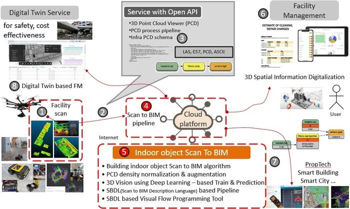
BIM E GIS Finalmente Integrati Con Usbim.Geotwin: La Soluzione ACCA Software Per Progettare E Gestire Edifici E Infrastrutture Integrando Dati GIS Con Modelli BIM

Integrando i due patrimoni informativi GIS, che offre una rappresentazione di contesto su scala urbana, regionale e/o nazionale, e BIM, che focalizza la propria attenzione sulla singola opera, è possibile ottenere un digital twin dell’opera contestualizzata nel proprio ambiente. usBIM.geotwin di ACCA software è la nuova piattaforma tecnologica per la digitalizzazione e la gestione geospaziale ...
professionearchitetto.it

Dubai Municipality Launches New Online System For Building Permits Services

Dubai Municipality has announced the launch of a new online system for building permits and control services aimed at streamlining procedures for customers in the emirate. The new system not only complies with the latest BIM standards and geographic information systems, but also facilitates user registration through digital ID and instant recognition. It enables smart ...
zawya.com
Itaipu Encerra Fase De Escaneamento 3D Da Usina

Itaipu Encerra Fase De Escaneamento 3D Da Usina

A empresa responsável pelo escaneamento tridimensional da Itaipu finalizou os trabalhos na primeira quinzena de maio. Encerrada essa primeira fase, será possível agora concluir a modelagem 3D de toda a Área Industrial para dar continuidade aos projetos executivos na Atualização Tecnológica da Binacional. Esse modelo 3D digital substituirá os documentos estáticos e permitirá, a partir ...
mundogeo.com
Arranca En Cartagena El Mayor Encuentro Nacional De Innovación Y Tecnología Portuaria

Arranca En Cartagena El Mayor Encuentro Nacional De Innovación Y Tecnología Portuaria

Durante tres días, el edificio CIM de la Universidad Politécnica de Cartagena se convertirá en la sede del VIII Congreso Nacional de la Asociación Técnica de Puertos y Costas (ATPYC). Se trata de uno de los encuentros más significativos en materia de innovación en ingeniería, consultoría y construcción de obras portuarias y costeras de cuantos ...
laverdad.es
El Ayuntamiento Firma El Segundo Convenio BIM Para Impulsar La Digitalización De La Gestión Urbanística Y Agilizar La Tramitación De Licencias

El Ayuntamiento Firma El Segundo Convenio BIM Para Impulsar La Digitalización De La Gestión Urbanística Y Agilizar La Tramitación De Licencias

El titular del Área de Desarrollo Urbano, Mariano Fuentes, ha firmado esta mañana el segundo convenio BIM (Building Information Modelling) con la Asociación de Promotores Inmobiliarios de Madrid (ASPRIMA), para agilizar los plazos de las licencias y para “eliminar la tasa invisible, esos costes financieros que se generan por los retrasos administrativos y que al ...
lacerca.com

How Bentley Systems’ 3DFT Could Conquer The Infrastructure Metaverse

Construction data can quickly scale into gigabytes and terabytes of data. The field is complicated because teams use various file formats to design, construct and operate a building or facility. Teams must often load the whole file into proprietary rendering tools before showing off a new design or collaborating on schedules. These files can be ...
venturebeat.com

Public Comment Requested On Revision To OGC 3D Streaming Community Standard, I3S

The Open Geospatial Consortium (OGC) seeks public comment on version 1.3 of the OGC Indexed 3d Scene Layer (I3S) and Scene Layer Package Format Community Standard. Version 1.3 adds support for Building Scene Layers. Building Scene Layers are derived from Building Information Models (BIM) and/or other 3D building data. Comments are due by September 18, ...
directionsmag.com