Geomaticians

Agriculture

Geospatial Mapping To Help Identify Threats To South Carolina Farmland

American Farmland Trust, in partnership with several South Carolina governmental and advocacy groups, is launching a tool that does precisely this to preserve vital farmland at risk of development. Palmetto 2040: Visioning Alternative Futures, Launching Solutions is a geospatial modeling and policy analysis tool designed to identify and model future outcomes, areas at highest risk ...
La IA ayuda a los pequeños agricultores y viticultores argentinos a competir al tiempo que atrae a una nueva generación

La IA Ayuda A Los Pequeños Agricultores Y Viticultores Argentinos A Competir Al Tiempo Que Atrae A Una Nueva Generación

Balussi, quien creció como hijo de un carpintero en una comunidad de productores de maíz en Argentina, fundó Agrobit, una compañía tecnológica que comenzó con software agrícola hace 40 años y en 2019 empezó a usar IA y aprendizaje automático para armar el primer sistema agrícola inteligente del país. Agrobit trabajó con Microsoft para construir ...
news.microsoft.com
El IRTA Desarrolla Una Web Predictiva Para La Demanda Hídrica De Lleida

El IRTA Desarrolla Una Web Predictiva Para La Demanda Hídrica De Lleida

En un contexto de cambio climático, las comunidades de regantes juegan un rol muy importante a la hora de gestionar y garantizar la disponibilidad del agua, tal y como se está viendo en la situación de extrema sequía actual. Por eso, es esencial que se modernicen y dispongan de herramientas para saber la demanda de ...
retema.es
Información Satelital Precisa Para Decidir La Siembra Del Trigo

Información Satelital Precisa Para Decidir La Siembra Del Trigo

Ante el inicio de la campaña de trigo, la Comisión Nacional de Actividades Espaciales (CONAE) pone a disposición de los productores y profesionales del sector agropecuario su Mapa de Humedad Superficial del Suelo, generado con datos de los satélites argentinos SAOCOM 1, con información precisa para la toma de decisiones al momento de sembrar el ...
argentina.gob.ar

Gugik Publikuje Model Pojęciowy Oraz Schemat Aplikacyjny Dla Mapy Glebowo-rolniczej

Główny Urząd Geodezji i Kartografii we współpracy z Instytutem Upraw Nawożenia i Gleboznawstwa – PIB oraz w uzgodnieniu z Ministerstwem Rolnictwa i Rozwoju Wsi opracował model pojęciowy bazy danych oraz schemat aplikacyjny GML dla mapy glebowo-rolniczej dla skali 1:5000 w postaci wektorowej. Większość dostępnych dzisiaj w PZGiK map glebowo-rolniczych w skali 1:5 000 opracowano od ...

WFP-Powered GIS to Help Lesotho Stay Ahead of Climate Shocks and Hunger

On Wednesday (31 May) the Government of the landlocked kingdom of around 2 million people in southern Africa launched a GIS (geospatial information systems) platform, facilitated by the World Food Programme (WFP) that could be a game-changer for the country on a number of fronts, not least in training and providing resources for up to ...
miragenews.com
L'agricoltura Del Futuro L'uso Di Droni Per Un'irrigazione Più Sostenibile Negli Uliveti

L’agricoltura Del Futuro: L’uso Di Droni Per Un’irrigazione Più Sostenibile Negli Uliveti

Un recente studio pubblicato sulla rivista Agronomy ha dimostrato come l’uso di immagini visibili e termiche acquisite da un drone possa essere un metodo efficace per monitorare lo stato idrico delle piante, la crescita della chioma e la resa degli ulivi. Questa scoperta potrebbe avere implicazioni significative per la gestione sostenibile dell’acqua in agricoltura. Gli ...
quadricottero.com
Mapping The Conflict Between Farming And Biodiversity

Mapping The Conflict Between Farming And Biodiversity

Food is one of society’s great moral quandaries. Its production pushes many species to the brink of extinction and the grazing of land that destroys ecosystems. For governments, industry, and communities to effectively balance agricultural needs with environmental needs, however, quantitative information is required. Researchers in Japan, including the Research Institute for Humanity and Nature ...
eurekalert.org

Esri España Y Seresco Aúnan Fuerzas Para Ofrecer Soluciones Al Sector Agrícola Mediante La Tecnología Arcgis

Esri, empresa líder mundial en tecnología geoespacial, y Seresco, especialistas y referentes en España en consultoría y sistemas de información orientados al registro, análisis predictivo y gestión de riesgos asociados al sector agroalimentario, colaborarán para ofrecer soluciones conjuntas que permitirán poner a disposición del sector los datos y las herramientas para la gestión sostenible de ...
dirigentesdigital.com
SmartSat Launches Maya Nula Research Program

SmartSat Launches Maya Nula Research Program

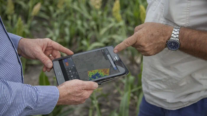
SmartSat Cooperative Research Centre (CRC), an Australian space research centre, announced on the 23rd of May that they have launched a new research program: Maya Nula. This program intends to develop Australian satellite Earth Observation (EO) capability with space sensor technology to advance Australia’s agriculture industry. The SmartSat-led initiative will facilitate innovative research projects to ...
spacewatch.global

Dig4vitis: Un Enfoque Innovador Y Sostenible Para Reducir El Uso De Pesticidas En La Viticultura

El proyecto Dig4Vitis liderado por las Universidades de Burgos y Valladolid busca reducir la utilización de pesticidas en la viticultura a través de una solución de agricultura de precisión que permita evaluar la deposición de pesticidas en viñedos comerciales mediante el uso de imágenes hiperespectrales y técnicas de Inteligencia Artificial en tiempo real. El objetivo ...
tecnovino.com

رونمایی از سامانه هوشمند نظارت بر حدنگاری اراضی کشاورزی

این سامانه که در همایش مشترک قضات ویژه حدنگاری (کاداستر) و مدیران کل ثبت سراسر کشور در مشهد رونمایی شددر راستای اجرای تفاهم نامه فی مابین سازمان ثبت اسناد و املاک کشور و وزارت جهادکشاورزی به منظور تسریع و پایش قراردادهای تطبیق و مستندسازی اراضی کشاورزی به صورت سیستم اطلاعات مکانی WebGIS طراحی شده است. ...
tahlilbazaar.com
Estudian Con Realidad Virtual El Impacto Del Fracking En Vaca Muerta

Estudian Con Realidad Virtual El Impacto Del Fracking En Vaca Muerta

El impacto de la industria petrolera en Vaca Muerta y el avance del fracking en las zonas productivas se investiga y mide en la región. Van identificando las áreas de riesgo. El uso de realidad virtual fue el gran atractivo. La mayoría de los participantes se colocaron los anteojos y navegaron la Cuenca del Comahue. ...
rionegro.com.ar
Geographic Technology Provides Landowners With Precise Tools When Making Land Management Decisions

Geographic Technology Provides Landowners With Precise Tools When Making Land Management Decisions

According to Lee Burras and Bradley Miller, agronomists at Iowa State University, advances in geospatial technology coupled with more traditional farming knowledge have allowed researchers and landowners to understand the land more intimately than ever before. Miller, who began his career working in water quality, has seen firsthand how soil can be impacted by the ...
extension.iastate.edu
Córdoba Actualizó Los Mapas Digitales De Propiedades De Suelo

Córdoba Actualizó Los Mapas Digitales De Propiedades De Suelo

A través de un trabajo interinstitucional, la provincia de Córdoba actualizó los mapas digitales, a escala semi-predial, de materia orgánica (MO), fósforo (P) y Ph. Estas actividades forman parte de la estrategia de Mapeo Digital de Suelos (MDS), en una labor colaborativa iniciada hace más de 3 años entre el Ministerio de Agricultura y Ganadería, ...
agroverdad.com.ar
How Just 1% Of Farmland Could Meet One Third Of Canada’s Energy Needs

How Just 1% Of Farmland Could Meet One Third Of Canada’s Energy Needs

Recent research into “agrivoltaics” — putting solar panels on a parcel of land that grows food — suggests that this isn’t always a dealbreaker. In fact, according to the paper, setting up certain types of solar panels alongside commercial plant crops can play a huge role in generating renewable energy in Canada. To study this, ...
theweathernetwork.com

Intermap To Supply Indonesia With 3D Digital Elevation Models

Intermap Technologies, a global leader in 3D geospatial products and intelligence solutions, announced a contract to supply 3D digital elevation models (DEMs) to reduce crop loss for an agricultural company in Indonesia. The country is utilising the Intermap’s precision data for monitoring and site assessment over large areas across the islands of Sumatra and Borneo. ...
fareasternagriculture.com

Neue Plattform Beleuchtet Die Bioökonomie

Eine biobasierte Wirtschaft, die sich an natürlichen Kreisläufen orientiert, nachhaltig und klimaneutral ist – das ist das Ziel der Bioökonomiestrategie der Bundesregierung. Doch entwickelt sich die Bioökonomie in allen Bereichen in die gewünschte Richtung? Die Nutzung von Biomasse kann zu Zielkonflikten führen, die nicht immer auf den ersten Blick sichtbar sind, weil sie global oder ...
idw-online.de

El Mapa De Recetas Fitosanitarias De Córdoba Creció Más De 500 Mil Hectáreas

El mapa de Recetas Fitosanitarias Digital (RFD) es una herramienta que permite la trazabilidad del sistema de recomendación y uso de fitosanitarios agrícolas en la provincia a nivel de una parcela o área geográfica particular. El RFD, desarrollado por la Dirección General de Fiscalización y Control de Córdoba, con el apoyo de IDECOR, muestra un ...
revistachacra.com.ar
Cattle Country Manitoba’s Agricultural Crown Grazing Lands – Assessing Potential For Growing The Beef Industry

Cattle Country: Manitoba’s Agricultural Crown Grazing Lands – Assessing Potential For Growing The Beef Industry

Researchers with the Department of Animal Science at the University of Manitoba have taken a closer look at the current productivity of agricultural Crown lands (ACL) in Manitoba for grazing. The new research has determined that unclaimed productivity within these areas can be economically valuable to producers, thereby supporting the strategies and goals outlined in ...
news.umanitoba.ca
Desarrollan Mapas Temáticos Que Reflejan Cambios Ambientales Producidos Por La Actividad Agropecuaria

Desarrollan Mapas Temáticos Que Reflejan Cambios Ambientales Producidos Por La Actividad Agropecuaria

Investigadores que trabajan en el Laboratorio de Investigación y Reflexión en Agroecología (LIRA), de la Facultad de Ciencias Agrarias y Forestales de la UNLP diseñan, a partir de diferentes índices calculados, mapas temáticos que permiten visualizar el riesgo ambiental de las actividades agropecuarias en la provincia de Buenos Aires. Cuando se habla de riesgo, entran ...
unlp.edu.ar
Smart Crop Startup Inks Deal With Satellite Imaging Company

Smart Crop Startup Inks Deal With Satellite Imaging Company

The California-based tech company is creating genetically engineered crops that can signal humans when they are attacked by pathogens, need nutrients, or feel stressed from drought. It is teaming up with Satellogic Inc. to begin developing a system to detect these human-engineered crop signals from space. A specially designed imaging instrument is scheduled to be ...
farmprogress.com
Sistema Georreferenciado Para Emergencias Rurales Del Partido De Olavarría

Sistema Georreferenciado Para Emergencias Rurales Del Partido De Olavarría

En un trabajo en conjunto entre la Dirección de Desarrollo Agropecuario y GIS de la Dirección de Gobierno Digital, ambas dependientes de la Secretaría de Desarrollo Económico del Municipio, se desarrolló SIGE: un sistema que ubica cada tranquera existente de establecimientos rurales del partido, que asimismo incluye una serie de herramientas para que, de manera ...
olavarria.gov.ar

Andalucía Tendrá Un Satélite Para Recoger Datos Agrícolas

Open Cosmos ha pasado la fase de revisión crítica y ya está en la de fabricación y ensamblaje del primer satélite andaluz (todavía sin nombre oficial), con la intención de que pueda ser lanzado este mismo año 2023 por un cohete Space X Falcon 9. El objetivo que se busca con este nanosatélite (tiene un ...
fly-news.es

La Teledetección Con Drones En La Gestión Del Olivar, Un Avance En La Digitalización Del Cultivo

La digitalización de la olivicultura permitiría hacer frente a los desafíos a los que se enfrenta el sector, como una mayor producción, calidad y trazabilidad haciendo un uso sostenible de los recursos. En los procesos de digitalización se necesitan grandes cantidades de datos, siendo la teledetección con drones una herramienta ideal para recolectarlos. El uso ...
interempresas.net
EPA Creates Water Quality Map Of Farm-related Pressure Areas

EPA Creates Water Quality Map Of Farm-related Pressure Areas

The Environmental Protection Agency (EPA) has developed a map which highlights how water quality is affected by farming activity in different areas of the country. The map, which was published this month, is divided into sub-basins, which are colour-coded to highlight different issues related to farming activity. A single sub-basin may be colour-coded with different ...
agriland.ie

Progetto C-farms: Parte La Fase Di Test Delle Pratiche Di Carbon Farming Nelle Aziende

Il progetto europeo Life C-FARMs è giunto alla fase di sperimentazione nelle aziende. Obiettivi di questo programma europeo, di cui Confagricoltura è partner, sono la realizzazione del Sistema Informativo Geospaziale Dimostrativo ad alta risoluzione (GIS-FARMs), che farà identificare il potenziale di mitigazione del settore agricolo della Regione selezionata, la Lombardia; lo sviluppo di un quadro ...
confagricoltura.it
Researchers Unveil Soybean Nutrients Distribution Map In China

Researchers Unveil Soybean Nutrients Distribution Map In China

Researchers from the Chinese Academy of Agricultural Sciences (CAAS) recently mapped the geographic distribution of soybean nutritional compositions in China. Researchers believe that the study, which was published in the journal Food Research International, provides scientific evidence for guiding the construction of high-quality soybean production bases in China. To clarify the spatial patterns of soybean ...
english.news.cn
Xfarm Technologies And FieldView Partner To Help Farmers Make Better Use Of Farm Data

Xfarm Technologies And FieldView Partner To Help Farmers Make Better Use Of Farm Data

FieldView and xFarm Technologies announced a new partnership to connect their respective platforms. The goal of this partnership is to enable an easy data exchange for farmers and help to consolidate and simplify farming operations. The partnership focuses on connecting the two platforms allowing users to share farm data between their FieldView and xFarm accounts ...
futurefarming.com