A new University of Maryland study suggests that Washington, D.C.’s most socioeconomically vulnerable neighborhoods are less equipped to handle runoff from heavy rainfalls made more frequent by climate change.
Published this month in Cities, the study reveals that the most densely populated communities in the District of Columbia, particularly in historically Black Southeast D.C., lack critical public resources, including sewer capacity and “green” infrastructure like rain gardens and trees, to adequately control stormwater.
In addition, the study points to the role of racist planning practices dating to the 19th century that fueled inequitable infrastructure distribution and housing conditions across D.C. as a contributing factor to which parts of the city are more prone to flooding.
“Stormwater and sewer infrastructure haven’t been historically studied through an equitable justice lens because it’s pretty invisible; it’s not an issue until it’s an issue,” said one of the authors, Marccus Hendricks, associate professor of urban studies and environmental planning. “These communities will encounter greater challenges in dealing with extreme weather events, which are becoming more frequent.”
Conducted through the University of Maryland’s Stormwater Infrastructure Resilience and Justice (SIRJ) Lab, the study used data from the District of Columbia’s Open Data DC website and ArcGIS, a geographical information systems mapping software, to investigate the relationship between infrastructure, urban features and socioeconomic vulnerability.
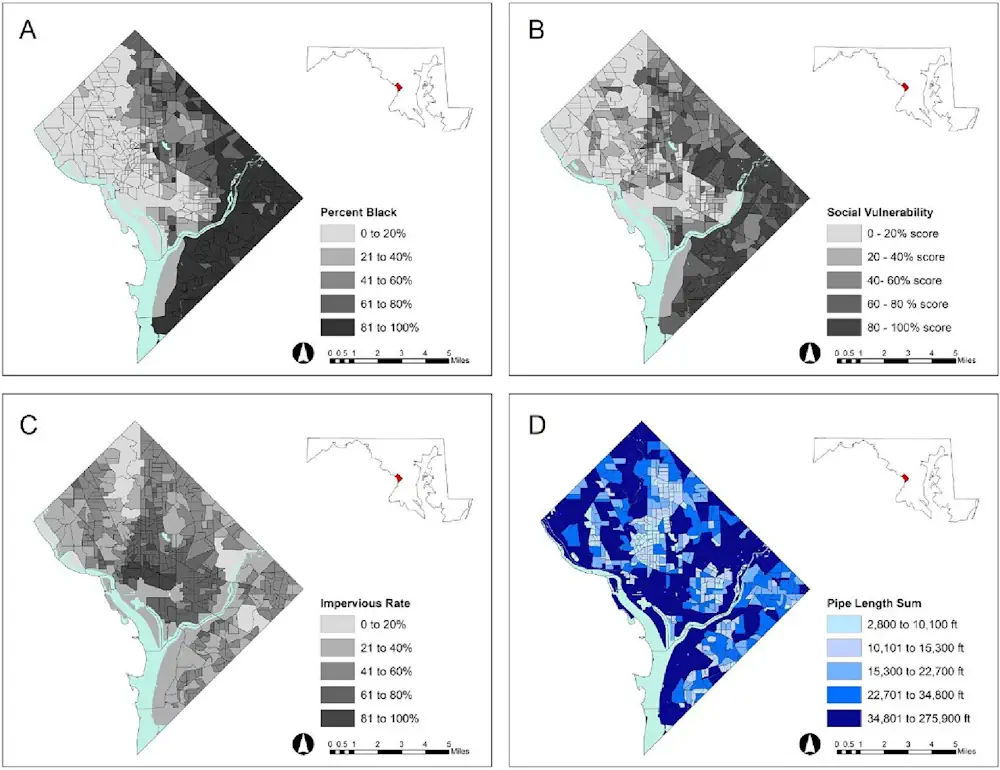
Researchers mapped the availability of sewer pipelines and similar “gray” infrastructure like pumping stations and culverts for more than 450 census block groups (geographical units with populations of 600 to 3,000 people) within Washington, D.C., correlating them with urban features like impervious pavement, housing density and green infrastructure such as green roofs and permeable pavement.
These factors were then linked with the socioeconomic makeup of the geographical units, including factors like median income, home value, rent prices, race and age.
While they found that the city’s stormwater infrastructure has been unable to keep pace with its population growth, green and gray infrastructure are less prevalent in densely populated areas with high levels of impervious surfaces—frequently marginalized communities of color—which creates excess runoff and overwhelms the outdated sewer structure.
The analysis revealed that areas with higher social vulnerability in the District tend to have less sewer pipes, as indicated by models examining stormwater infrastructure capacity across census block groups.