In the paper, “Extended SLIC superpixels algorithm for applications to non-imagery geospatial rasters,” published in the International Journal of Applied Earth Observation and Geoinformation, researchers from Adam Mickiewicz University and University of Cincinnati proposed an improved version of the popular SLIC algorithm for image segmentation, known as extended SLIC, to be applicable on multidimensional spatial raster datasets. The authors show that applying the extended SLIC algorithm, which uses a “native” data distance, can result in better segmentation/regionalization. They tested the algorithm on three datasets of varying dimensions and compressibility, including raster data of land cover fractions, climatic time series, and elevation data.
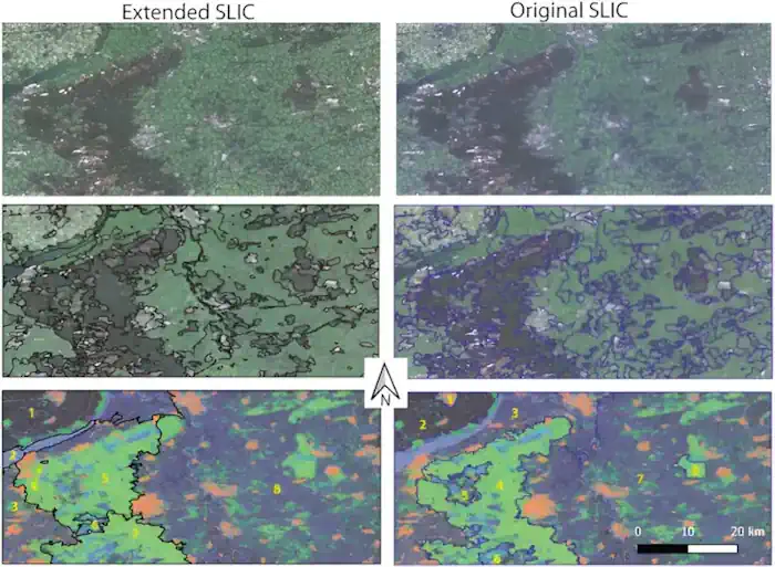
In the first testing example, the goal was to create regions of homogeneous land cover. They found that the extended SLIC algorithm outperformed the original SLIC algorithm in terms of segmentation accuracy, despite the high dimensionality of the data.
In the second example, the authors used raster data of climatic time series with 24 variables to create regions of similar temperature and precipitation variability. In this case, the authors found that the extended SLIC algorithm showed a slight advantage over the original SLIC algorithm. Finally, in the third example, the authors used a set of topographic features to detect dunes in Algeria, which resulted in the least compressible data of the three examples. In this case, the extended SLIC algorithm showed a significant advantage over the original SLIC algorithm. Their results demonstrated that the advantage of the extended SLIC algorithm was inversely proportional to the compressibility of the data to just three dimensions. While the most compressible data, the raster of climatic time series, showed mixed results, with five of ten metrics favoring the extended SLIC and four favoring the original SLIC, the least compressible data, the topographic features dataset, showed a significant advantage for the extended SLIC algorithm.