Hundreds of monumental stone heads dot the coastline of the remote Pacific island of Rapa Nui, or Easter Island. Settled by a small group of Polynesian seafarers about 900 years ago, it’s a fascinating place that has been the subject of fierce debate about how complex societies can sometimes ruinously fail.
Some experts, such as geographer Jared Diamond in his 2005 book, “Collapse,” used Easter Island as a cautionary example of how the exploitation of limited resources can result in catastrophic population decline, ecological devastation, and the destruction of a culture through infighting.
Other researchers suggest the exact opposite — that Easter Island is a tale of how an isolated people created a sustainable system, allowing a small but stable population to thrive for centuries until first contact with European colonial powers in the early 18th century.
Now, research involving remote-sensing data and machine learning to map evidence of island farming offers a fresh clue that may help unravel the mysterious demise of the island’s original civilization. The new finding suggests that the island was not densely populated, making ecological collapse a less likely scenario.
“There’s all these bits of evidence that have been collected over the past 15 or 20 years that kind of start to throw a wrench” in the collapse story, said Dr. Dylan Davis, lead author of the study that published Friday in the journal Science Advances.
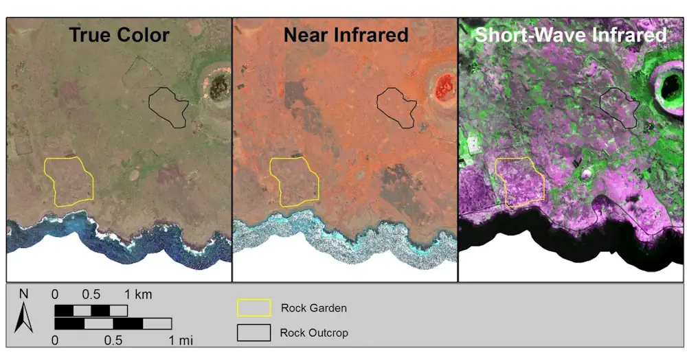
The rock gardens had covered up to 21.1 square kilometers (8.1 square miles) and could have sustained up to 17,000 people, previous research suggested. That February 2013 finding bolstered the idea that people drained Rapa Nui’s limited resources.
Archaeologists have identified the remains of rock gardens on which islanders would have grown sweet potatoes and other crops. The scattered and pulverized rocks make the land more productive by adding and sealing in nutrients and moisture and protecting young plants from winds — an ancient farming technique also known as rock mulching.
However, in the new study, Davis and his colleagues found that the maximum number of people on Rapa Nui was nearly 4,000, less than one-quarter of that higher estimate.
The team determined the substantially smaller population count by using a machine learning model trained to identify rock gardens from high-resolution shortwave infrared and near-infrared data gathered by satellite.
The researchers found that rock gardens, identifiable by patterns of vegetation and soil composition, covered about three-quarters of 1 square kilometer (0.4 square mile), and rock garden cultivation alone would only have supported around 2,000 people. When combined with estimates for the availability of fishing and other marine foods, the team believes Rapa Nui could have sustained a population of 3,901 people.
Davis said the team manually verified the model, which was 83% accurate. “This is good at the moment because of the data that’s available,” he said. “If there were any obvious errors, we removed them.”