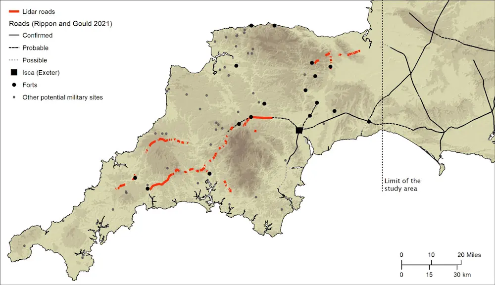
Archaeologists at the University of Exeter have used laser scans collected as part of the Environment Agency’s National LiDAR Programme to identify new sections of road west of the previously understood boundary. Among the things it reveals is that far from Exeter being the main nerve centre of the network, it was North Tawton that supported strategically vital connections with tidal estuaries north and south of Bodmin and Dartmoor. These findings are explored in Remote Sensing and GIS Modelling of Roman Roads in South West Britain which has been published in the Journal of Computer Applications in Archaeology.
The research was led by Dr Christopher Smart and Dr João Fonte, specialists in landscape archaeology and the heritage of the Roman Empire, in Exeter’s Department of Archaeology and History. Dr César Parcero Oubiña, from the Institute of Heritage Sciences, Spanish National Research Council in Spain, specialist in geospatial technologies applied to archaeology, led the modelling of the Roman roads network.
The National LiDAR (Light Detection and Ranging) Programme was conducted between 2016 and 2022 by the Environment Agency covering the whole of England, and the data was made available via the DEFRA Data Services Platform. It transformed the amount of terrain mapped of Devon and Cornwall, which had previously stood at just 11%. The Exeter team, working with public volunteers, and funded by the National Lottery Heritage Fund as part of the Digital Skills for Heritage initiative, studied the scans and together they were able to map around 100km of additional roads.
Although this represented a significant advancement, the overall picture remained fragmented and patchy, with large portions of the map showing no evidence of Roman roads. So, the team developed a geographic information system predictive model, which could intelligently fill in the gaps as to the likely layout of the network. Using an approach based upon Least Cost Paths — the optimal connections between two or more points — and other methods, such as focal mobility networks and transit corridors, the team began to plot primary and secondary ‘nodes’ across the two counties. These included permanent military fortifications, including the known forts of Old Burrow and The Beacon at Martinhoe, as well as the settlements at Exeter and North Tawton. They then calculated the easiest routes between these points. And when the team returned to the LiDAR scans, they were able to identify a further 13km of Roman road within a short distance predicted by the model. The final stage saw the researchers use focal mobility networks and transit corridors to extend the road network to areas that lay beyond the main Roman sites known in the region, suggesting some secondary or tertiary routes alternative to the single best optimal path in the process. This established a number of new ‘terminal points’, particularly in the far west of Cornwall and along its south coast.