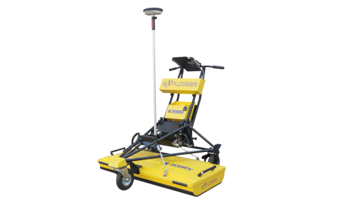
Tesmec’s mobile mapping system, announced at bauma 2022, is a lidar scanner that is designed to be placed atop their georadar explorer 2.0, a ground probing radar system. With this attachment on the top of the radar system, users are able to detect underground utilities using the ground probing radar while simultaneously capturing high-precision digital 3d surveys of the environment above the ground. Through a mix of 3d point cloud data obtained through the lidar technology as well as 3d point cloud data obtained through stereoscopy algorithms applied to the images acquired by high resolution matrix cameras, users are able to come away with a georeferenced 3d reconstruction of a site, with an artificial intelligence network processing the data to produce the resulting point cloud.