In the southwest of Colombia lies the department of Nariño, known for its majestic mountains that give rise to one of the world’s most excellent coffees, thanks to its unique qualities and characteristics. However, these same mountains represent a considerable challenge for agricultural supply chains in the region.
In the scientific article entitled “Evaluation of spatial accessibility levels through infrastructure-based models: A case study in the Department of Nariño, Colombia”, published in the scientific journal Perspectiva Geográfica, researchers from the Universidad del Valle (Univalle) evaluated the advantages and disadvantages of the different municipalities in terms of spatial accessibility in the Department of Nariño, Colombia, through geographic information systems (GIS). “Our research not only aims to optimise the logistics and quality of coffee, but also to improve conditions and opportunities for local farmers, thus contributing to the sustainable development of the coffee industry in the department”
Daniel Mauricio Goyes Chaves, an engineering doctoral student with an emphasis in Industrial Engineering at Univalle, part of the Traffic, Transport and Roads Research Group (GITTV) and the Logistics and Production Research Group, described how researchers integrated various mathematical modelling techniques with the power of Geographic Information Systems (GIS) to analyse geographic data. “In addition to this approach, we have also carried out a thorough analysis of the accessibility of producers in the region,” said Goyes. In addition, Goyes highlighted that he worked on this research with professors Carlos Alberto Arango Pastrana from the Department of Administration and Organisations at Univalle, as well as Ciro Jaramillo Molina, from the Faculty of Engineering at the same university.
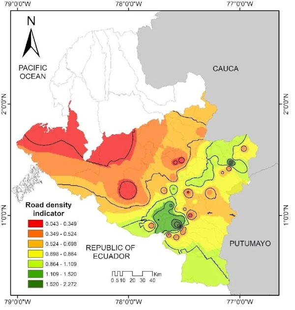
“We generate more than 3200 routes in the network between different nodes (64 municipal capitals), and then compare them with the most efficient route (Euclidean distances) in order to analyse the quality and efficiency of the network,” said Goyes, adding that another important factor that is possible to analyse is to identify alternative routes if there is a blockage. Professor Jaramillo explained that the Road Density Indicator (RDI) is the ratio between the length of the total road network in an area and the total surface area. According to Goyes, the research carried out has a local focus, although our future vision is to be able to analyse and compare the situation of the department at national and international level, taking into account its proximity to Ecuador. “The next step in the research involves the development of more advanced and effective tools focused on decision making regarding the planning and analysis of the department’s transport infrastructure, as support for transport ministries, the National Infrastructure Agency (ANI), the National Roads Institute (INVIAS),” said Goyes.