While some parts of the world suffer extreme heat and persistent drought, others are being flooded. Overall, continental water volumes vary so much over time that global sea levels fluctuate significantly too. By combining the hydrological model WaterGAP with GRACE satellite data, a team of geodesists at the University of Bonn have come up with a new set of data that shows how the total distribution of water over the Earth’s land surfaces has changed over the past 20 years more accurately than ever before. Their findings have now been published in the Journal of Geodesy.
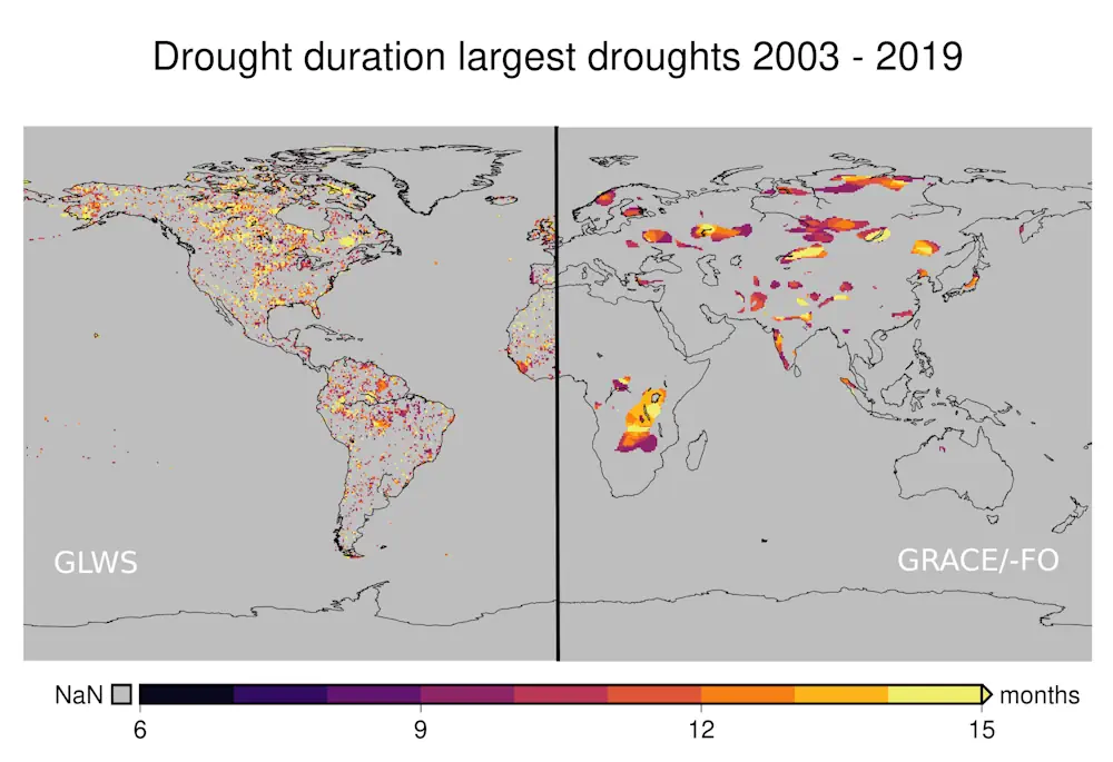
“The new method allows us to test out model calculations on the future effects of climate change, particularly how rising temperatures and changes in precipitation patterns will impact the water balance in different parts of the world,” says Prof. Dr. Jürgen Kusche from the Institute of Geodesy and Geoinformation at the University of Bonn. The process involves comparing climate models, which invariably cover a certain period of time in the past, with the results of actual measurements, and Kusche and his team are planning several such studies over the coming months. The improved resolution that the team has achieved shows that droughts are significantly more common across the world than the GRACE satellite data would suggest in isolation. “What we’re seeing is that even extensive droughts like the massive one that struck the whole of the Amazon in 2010 are spread across much wider areas than the satellite data indicates on its own,” Kusche says. “This means that the satellites aren’t picking up many of the more localized droughts.”
Working together with counterparts from Goethe University Frankfurt and the Polish capital Warsaw, a team of researchers from the University of Bonn has now combined satellite measurements with high-resolution meteorological data for the first time.
“What’s special about this method is that it’s enabled us to improve the resolution of the water distribution maps that are generated from around 300 kilometers to 50 kilometers,” explains Kusche, who is a member of the Modeling and Sustainable Futures Transdisciplinary Research Areas and the Regional Climate Change Collaborative Research Center at the University of Bonn. To do so, the researchers used the “WaterGAP” hydrological model developed at Goethe University Frankfurt plus a mathematical technique borrowed from weather forecasting.