Methane is a powerful greenhouse gas and is the second-largest contributor to climate warming after carbon dioxide. A tonne of methane, despite its shorter lifespan of about 10 years in the atmosphere, can retain an astounding 30 times more heat than a tonne of carbon dioxide over the course of a century. This means that when it comes to warming our planet, methane is a potent player.
But here’s the good news: because methane doesn’t stick around as long as carbon dioxide, it provides us with an opportunity to take relatively swift climate action. If we reduce methane emissions, we can actually see a tangible reduction in global methane levels within just a decade. This, in turn, helps to mitigate the enhanced greenhouse effect.
Now, let’s talk about ‘super-emitters’. While methane emitters refer to any source of methane ranging from natural processes like wetlands or human activities such as agriculture, methane super-emitters release a disproportionately large amount of methane compared to other emitters.
These are typically found amongst industrial facilities, such as oil and gas operations, coal mines, or even landfills, that have equipment or infrastructure issues leading to significant methane leaks. These super-emitters are the low-hanging fruits in our quest to cut emissions. Fixing these super-emitters doesn’t require complex or expensive solutions. In many cases, relatively simple repairs can result in significant climate gains.
However, there’s a challenge: we first need to identify these super-emitters. That way, we can target our efforts effectively and start making a difference in the fight against climate change. The Tropomi instrument onboard the Copernicus Sentinel-5P satellite is the only satellite instrument that produces a global map of methane concentrations every day. The satellite measures methane by observing Earth’s atmosphere and, specifically, the shortwave infrared bands. These bands are like unique fingerprints for methane, allowing Sentinel-5P to detect its presence with remarkable precision.
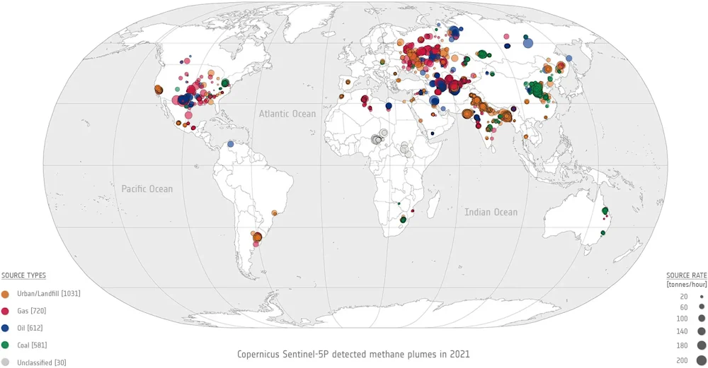
Researchers from SRON Netherlands Institute for Space Research have announced a new algorithm that automatically discovers methane super-emitter plumes in Sentinel-5P data using machine learning. It also automatically calculates the associated emissions based on the measured concentrations and concurrent wind speeds. Berend Schuit from SRON explains, “Before, we manually identified the largest emitters, but it remains difficult to search through the millions of Tropomi pixels. A methane plume often only covers a few pixels. We now automatically get a list of detections from the machine learning model every day.
“We check those manually every week to make sure we are confident about the detections. What remains, dozens of methane plumes every week, we publish online. We communicate persistent leaks to other satellites with higher resolution so they can precisely identify the source … This information is used by the United Nations’ International Methane Emissions Observatory to find a solution together with the responsible companies or authorities … For the first time, we now get a good global picture of these super-emitters. In our publication, we describe the 2974 plumes that we found in 2021; 45% originate from oil and gas facilities but we also see plumes from urban areas (35%) and coal mines (20%).”