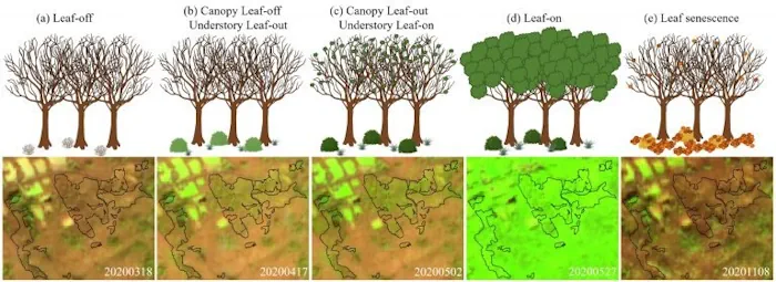
Distinguishing separate plant species from one another is hard even for human eyes; however, a team of UConn researchers was able to use data from a satellite nearly 500 miles (786km) above Earth's surface to map Connecticut's forest understory plant communities. The results of this study are published in Remote Sensing of Environment. The understory, or what grows beneath the canopy, is a crucial part of the forest ecosystem. From providing habitat and food for animals, to cycling nutrients, to acting as a nursery for younger trees that will one day become the canopy, the understory plays essential roles in a healthy forest. One species that depends on certain understory habitats is the New England Cottontail rabbit. Assistant Professor in Residence Chadwick Rittenhouse, a researcher in the Department of Natural Resources and the Environment in UConn's College of Agriculture, Health and Natural Resources was interested in locating areas that could support cottontails to monitor their dwindling populations. Curious about potential methods to track these habitats down, he spoke with Zhe Zhu, the director of UConn's Global Environmental Remote Sensing Laboratory (GERS), to see if remote sensing technologies could help. Zhu notes the challenge of tackling this question using remote sensing is in figuring out how to use satellite technology to see what is happening beneath the tree canopy. The researchers started by focusing on a few one-kilometer by one-kilometer plots for a pilot study. Shi Qiu, Research Assistant Professor in the Department of Natural Resources and the Environment, says, "We compared data from different satellites which have different spatial resolutions. For example, Landsat is a popular satellite with a 30-meter resolution. On our first try, we found the resolution was not good enough, so we switched to a higher spatial resolution and found good resolution with Sentinel-2, which has a 10-meter resolution.“ With the right sensors identified, the researchers found a temporal gap they call the "observation window," after understory plants have greened up but right before the trees leaf out, says Zhu. The researchers developed a strategy that distinguished plant species with an overall accuracy of 93% and determined that around 53% of Connecticut's understory is now comprised of invasive plant species like barberry, bittersweet, winged euonymus (burning bush), and multi-flora rose.