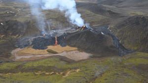
On 19 March 2021, the volcano Fagradalsfjall began to erupt, suggesting that volcanoes on Iceland’s Reykjanes Peninsula had awakened from an 800-year slumber. Although most volcanism in Iceland occurs in regions far from population centers, eruptions on the Reykjanes Peninsula can threaten residents. Pedersen and a team of scientists came together to create maps to prepare the public for the evolving events. These mapping efforts were recently published in Geophysical Research Letters ... Scientists began gathering data using both satellite and airborne images. Although satellites offer ideal coverage of a region, clouds often obscure the satellite view of the sky over Iceland. For this reason, the team paired satellite data with aerial photographs collected during 32 photogrammetric surveys. Researchers then used the data to construct topographic maps and monitor how the landscape was changing between surveys. These maps illustrated the ongoing evolution of the eruption.