A growing number of heritage buildings primed for demolition in London will live on virtually with the help of high-end 3D technology.
The city has amassed a small but growing number of virtual building replicas as part of its regular process to document and photograph heritage properties, or properties with heritage components, before their date with the wrecking ball.
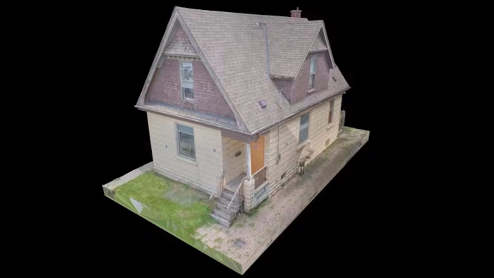
Three buildings have already been documented this way and two are on their way. They include two properties along Wellington Road near Grand Avenue where work is being done on the southern leg of the city’s bus rapid transit network.
16 Wellington Rd., a one-storey Art Moderne-style building built in 1946, is set to be demolished, while 28 Wellington Rd., a storey-and-a-half Queen Anne-style home constructed in 1906, was levelled earlier this year, along with two identical homes on either side of it.
Both were documented last year at the request of the city by the London-based firm SkyDeploy, which used drone photogrammetry and LiDAR scans, or light detection and ranging, to create detailed 3D duplicates which can be moved and viewed close up in virtual space.
“I don’t think there’s a lot of awareness about the capabilities and how straightforward this is. It may seem very daunting and expensive and out of reach, but it’s really become a commodity,” said Ted Strazimiri, who founded SkyDeploy in 2017.
The city engaged SkyDeploy for drone inspections of buildings, including the London Normal School. The resulting 3D model sparked the city’s interest in the technology.
Kyle Gonyou, the city’s heritage and urban design manager, values the technology for its precision, speed, and cost-effectiveness. The process yields both 3D models and 2D technical drawings of building elevations.
“The high level of detail provides an excellent record of buildings before demolition,” Gonyou stated.
Advancements in photogrammetry and LiDAR, propelled by drones, high-resolution cameras, sophisticated software, and computing power, have revolutionized digital documentation.
Strazimiri’s goal is to create highly detailed 3D models using thousands of photographs from every building angle. The improved technology allows drones to autonomously scan and map images onto a 3D model.
Collecting data for properties like 16 and 28 Wellington Rd. took about six hours, with processing into a rendered model taking up to a week, resulting in very large files.
Whether these models will be publicly accessible remains uncertain due to file size challenges. However, public access would greatly benefit historians, preservationists, and residents, notes Michelle Hamilton, a public history professor.
Hamilton emphasizes the value of 3D models for studying both existing and demolished buildings. The technology’s potential has also caught the attention of Ontario heritage planners.
Strazimiri educates others on using this technology, with projects like scanning a Chicago toll road bridge for structural damage.
Gonyou acknowledges the benefits of digital preservation but prefers to see heritage buildings physically intact rather than solely in digital form.