Geomaticians

English

Bangladesh To Introduce Drone Technology To Assess Crop Losses

Bangladesh is preparing to introduce remote sensing and drones to detect crop damage caused by extreme weather events or diseases. Around 20 officers of the Department of Agricultural Extension (DAE) are initially receiving training to learn how to use the state-of-the-art technologies. Malay Choudhury, additional secretary, Ministry of Agriculture, and Edimon Ginting, ADB Country Director ...
en.prothomalo.com

Overture Maps Foundation Releases The First Beta Of Its Open Map Dataset

The Overture Maps Foundation today launched the first beta of its global open map dataset. With this, the foundation, which is backed by the likes of Amazon, Esri, Meta, Microsoft and TomTom, is getting one step closer to launching a production-ready open dataset for developers who need geospatial data to power their applications. “This Beta ...
techcrunch.com
Brazil Looking To Improve Geological Mapping System For Mining

Brazil Looking To Improve Geological Mapping System For Mining

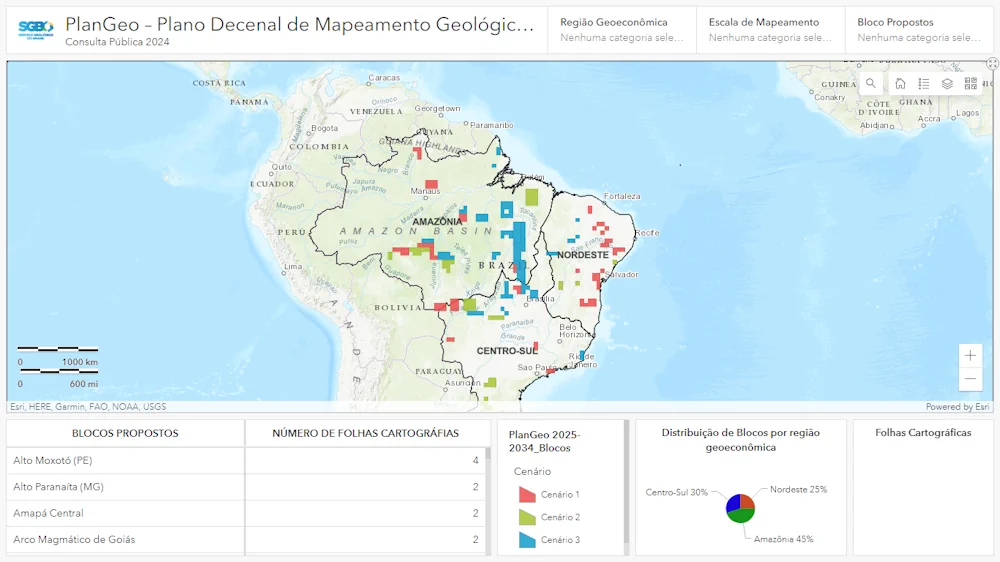
The Brazilian geological survey department, SGB, launched a public consultation to improve the country’s geological mapping system for the mining sector. The public consultation will be open until June 15. “This action is part of the 10-year basic geological mapping plan (PlanGeo) and is aimed at receiving proposals from the mining sector and civil society ...
bnamericas.com

Barcelona Bus Route Removed From Map Apps To Tackle Tourist Overcrowding

While some places will go to any lengths to attract visitors, residents of La Salut neighbourhood in Barcelona are celebrating a move to wipe themselves off the map. For years, residents had complained that they could not get home because the number 116 bus was always crammed with tourists visiting Antoni Gaudí’s Park Güell. The ...
theguardian.com

Microsoft, Siemens Join Forces To Standardize Digital Twin Languages

In a collaborative move with the W3C Consortium, Siemens and Microsoft have announced their commitment to converge the Digital Twin Definition Language (DTDL) with the Thing Description standard from international standards organization, W3C. By unifying both languages, customers are offered consistent modeling experiences, mitigating fragmentation in an evolving IoT landscape. With customers typically deploying a ...
thefastmode.com
Satellite Shows Hazards of US Winter Rivers

Satellite Shows Hazards of US Winter Rivers

Researchers from the University of Alaska Fairbanks have developed a new technology using synthetic-aperture radar (SAR) to detect hazardous sections of open water in frozen rivers in Alaska during winter. This technology can also be applied across the Arctic, where open water zones pose similar dangers. By identifying these open water zones, researchers hope to ...
globeecho.com

The Integrated Transport Centre Signs A MoU With A Leading Japanese Company “Location Mind” In Research And Development

On the sidelines of the 10th session of the Abu Dhabi Japan Economic Council, held in the capital Abu Dhabi, the Integrated Transport Centre (ITC) of the Department of Municipalities and Transport (DMT) in Abu Dhabi signed a strategic Memorandum of Understanding (MoU) with “Location Mind”, a leading Japanese company in the field of research, ...
zawya.com

Unlocking The Secrets Of Forest Heights: The Role Of GEDI Lidar Technology

A team of researchers has unveiled a novel approach to accurately characterizing tree height composition in forests using the Global Ecosystem Dynamics Investigation (GEDI) Light Detection and Ranging (LiDAR) technology. This study marks a significant advancement in our understanding of forest ecosystems, shedding light on the intricacies of tree height variability and its implications for ...
eurekalert.org
London Gatwick Airport Builds Geospatial Platform With Esri GIS

London Gatwick Airport Builds Geospatial Platform With Esri GIS

London Gatwick has created a new geospatial platform using Esri’s ArcGIS to support multiple operational areas at the airport, including engineering and environmental services. The system is already making engineering and construction works safer by reducing accidental strikes on buried utilities and enabling better management of the airports biodiversity. London Gatwick is one of the ...
gim-international.com
X1 Pro GNSS Receiver Enhances Surveying Precision

X1 Pro GNSS Receiver Enhances Surveying Precision

SingularXYZ has presented its latest innovation for geospatial professionals: the X1 Pro GNSS receiver. This new device aims to refine precision in surveying technology with a range of features tailored to streamline operations and improve accuracy. Central to the X1 Pro is its enhanced HD colour screen, providing users with clear visibility for monitoring status ...
gim-international.com

S. Korea, Japan To Cooperate In Developing Satellite Navigation System

South Korea and Japan will collaborate on the development and operation of regional satellite navigation systems in East Asia, Seoul’s science ministry said Tuesday. The two countries signed a memorandum of cooperation (MOC), designed for practical cooperation in developing and operating their respective satellite systems in the region, according to the Ministry of Science and ...
en.yna.co.kr

Geospatial Mapping And AI To Help Tackle Energy Gap In Africa

Energy modellers and researchers have developed a geospatial mapping model they say can help address the electricity access gap in Africa. The model has been developed by the International Energy Agency (IEA), researchers at Massachusetts Institute of Technology, University of Massachusetts Amherst and Electricity Growth and Use In Developing Economies. By mapping which buildings are ...
esi-africa.com

New PSGA Data Will Help Speed Up Emergency Response Times

A new selection of location datasets, including two new products, have been released today (Thursday 28 March) as part of the Public Sector Geospatial Agreement (PSGA). The new data and products have been delivered by Ordnance Survey (OS) and are set to support customers across a range of markets, including the emergency services, sustainability, land ...
gov.uk

Dublin Urban Rivers Life Project Selects ESRI To Reduce Levels Of Wastewater

Geographic information systems (GIS) provider Esri Ireland has been chosed by Dublin Urban Rivers Life (DURL) project to help prevent preventing circa 13 million litres of polluted wastewater from entering Dublin rivers annually. DURL is a joint venture between South Dublin and Dún Laoghaire-Rathdown County Councils, with funding received from the EU Life Programme. It ...
techcentral.ie
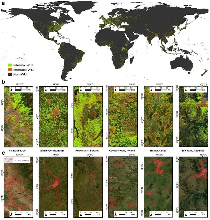
HKU Remote Sensing And Landscape Scholars Reveal Global Wildfire Risk Trends In Wildland-Urban Interface Areas (1985-2020)

HKU Remote Sensing And Landscape Scholars Reveal Global Wildfire Risk Trends In Wildland-Urban Interface Areas (1985-2020)

Wildfires present complex socio-economic and ecological challenges, as they devastate vegetation, endanger communities, and cause extensive environmental, wildlife, and human health impacts. These consequences include severe air pollution and soaring firefighting costs. Wildland-Urban Interface (WUI) areas, which are transition zones between wilderness and human-developed land, are particularly susceptible to wildfires. The risk is heightened due ...
eurekalert.org

Geospatial Commission-Funded Tool Demonstrates Potential For AI To Transform Decisions About Land Use

The Geospatial Commission, part of the Department for Science, Innovation and Technology (DSIT), has partnered with The Alan Turing Institute to explore the role that artificial intelligence (AI) can play in long-term decisions about how to use land. The UK is facing significant and competing pressures for its land. Advances in spatial data science and ...
gov.uk

Organic Farms Can Have Mixed Effects On Pesticide Use Depending On Their Neighbors

Organic agriculture may be as old as dirt, but that doesn’t mean its impacts are fully understood. A team of scientists in the United States and Canada are doing their part to change that. Researchers at UC Santa Barbara, University of British Columbia, and University of Colorado Boulder discovered that organic farming significantly affects the ...
news.ucsb.edu
Estimating Coastal Water Depth From Space Via Satellite-Derived Bathymetry

Estimating Coastal Water Depth From Space Via Satellite-Derived Bathymetry

With the development of shipborne echo sounders in the early 20th century, bathymetric surveys saw massive leaps in both accuracy and convenience. However, even with modern echo sounders, there are still many hardships to overcome when conducting bathymetric surveys. These include high cost, unpredictable weather, high ship traffic, and potential geographic or diplomatic issues, to ...
eurekalert.org

NVIDIA Announces Earth Climate Digital Twin

To accelerate efforts to combat the $140 billion in economic losses due to extreme weather brought on by climate change, NVIDIA today announced its Earth-2 climate digital twin cloud platform for simulating and visualizing weather and climate at unprecedented scale. Part of the NVIDIA CUDA-X™ microservices, announced separately today, Earth-2’s new cloud APIs on NVIDIA ...
nvidianews.nvidia.com
Introducing Floorlocator, A System That Enhances Indoor Navigation

Introducing Floorlocator, A System That Enhances Indoor Navigation

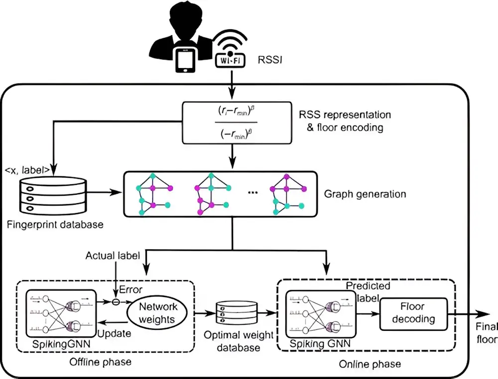
Indoor positioning is transforming with applications demanding precise location tracking. Traditional methods, including fingerprinting and sensor-based techniques, though widely used, face significant drawbacks, such as the need for extensive training data, poor scalability, and reliance on additional sensor information. Recent advancements have sought to leverage deep learning, yet issues such as low scalability and high ...
techxplore.com
Detecting Heavy Precipitation Events Directly With GPS Data

Detecting Heavy Precipitation Events Directly With GPS Data

An exceptionally severe storm swept over Zurich on 13 July 2021 shortly before 2 a.m., with howling squalls, constant lightning and torrential rain that awakened people with a start. Benedikt Soja, Professor of Space Geodesy, got little sleep that night. “It was one of the most severe storms I’ve ever witnessed. I woke up in ...
phys.org
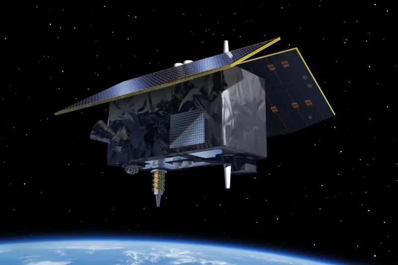
ESA Will Launch Genesis System To Measure Earth With Millimeter Precision

ESA Will Launch Genesis System To Measure Earth With Millimeter Precision

European Space Agency (ESA) allocated €76.6 million to develop the Genesis orbital observatory, which will be able to determine the position of objects on Earth with an accuracy of one millimeter. Another €156.8 million has been allocated for the launch of a low-orbit constellation of devices to test and improve the reliability of satellite navigation. ...
technewsspace.com
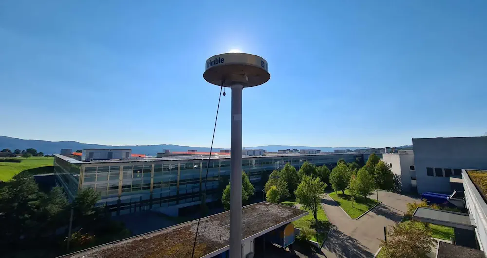
Trimble And Radiodetection Combine Survey-Grade Positioning With Underground Utilities Locating Measurement Workflows

Trimble And Radiodetection Combine Survey-Grade Positioning With Underground Utilities Locating Measurement Workflows

Trimble and Radiodetection announced today a collaboration to improve the technology used in the utility measurement and mapping process. Through the integration of the Trimble® Catalyst™ DA2 GNSS system and Radiodetection’s RD MapTM+ application and precision locator products, the software and hardware integration streamlines utility-locating workflows to provide high-accuracy measurement capabilities for the creation of ...
directionsmag.com

Geospatial Commission Joins UK Centre For Seabed Mapping

The Geospatial Commission had today (Wednesday 20 March) become the 31st member of the UK Centre for Seabed Mapping (UK CSM). The UK CSM, which is administered by the UK Hydrographic Office (UKHO), was created in June 2022 to spearhead a coordinated approach to the collection, management and access of seabed mapping data and to ...
gov.uk
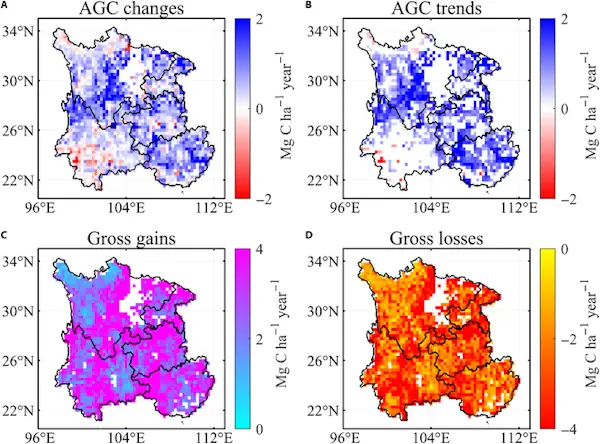
Satellite Data Illuminate Carbon Sequestration Success In Drought-Stricken Southwest China

Satellite Data Illuminate Carbon Sequestration Success In Drought-Stricken Southwest China

Recent research highlights a significant rise in Southwest China’s aboveground carbon levels between 2013 and 2021, showcasing the area’s capacity to counterbalance the negative impacts of severe droughts. This development emphasizes the vital role of Southwest China as a carbon sink, attributed to substantial ecological efforts and the deployment of cutting-edge remote sensing methodologies. For ...
spacedaily.com
Satellites Track The Tiny Silver Fish Hugely Important To Marine Life

Satellites Track The Tiny Silver Fish Hugely Important To Marine Life

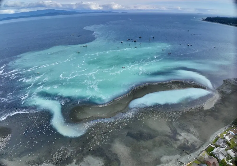
A new scientific endeavour has taken to the sky using high-tech drones and satellite images to understand better the annual spring herring spawn vital to salmon and wildlife on the West Coast. Between February and March each year, frigid ocean waters transform to a milky tropical-looking turquoise green when male herring release milt to fertilize ...
nationalobserver.com
AI And Drones Aid Farmers With Identifying Botrytis

AI And Drones Aid Farmers With Identifying Botrytis

Researchers from Unmanned Valley, Greenport DB, and NL Space Campus in the Netherlands have successfully developed an AI model that enables drones to identify the disease botrytis. The model leverages artificial intelligence to analyze vast amounts of drone data, resulting in a detailed map that pinpoints, with millimeter precision, which plants are diseased or at ...
futurefarming.com
Flightradar24’s New GPS Jamming Map

Flightradar24’s New GPS Jamming Map

We’re pleased to release our new GPS jamming map tool. The new map allows users to view areas of GPS jamming and interference around the world in an easy to understand visual format. As part of the ADS-B messages we receive from each aircraft, the Navigation integrity category (NIC) encodes the quality and consistency of ...
flightradar24.com

Saudi Ministry Launches GIS-Enabled Digital Platform For Water Management

The Ministry of Environment, Water, and Agriculture has announced a significant step forward in water management and planning by signing a contract to establish a geographical information system (GIS) for water planning. This initiative aims to create a smart water digital platform aligning with international best practices for the water sector within the Kingdom. Dr. ...
zawya.com

ESA-JRC Opens Registration For GNSS Summer School

The European Space Agency (ESA) and the European Commission’s Joint Research Centre (JRC) are collaborating to host the 15th edition of the International Summer School on Global Navigation Satellite Systems (GNSS). The course is scheduled to take place in Novo Mesto, Slovenia, from July 15 to 26, 2024. The summer school invites graduate students, Ph.D. ...
gpsworld.com