Geomaticians

English

AI Shows How Field Crops Develop

AI Shows How Field Crops Develop

Researchers at the University of Bonn have developed software that can simulate the growth of field crops. To do this, they fed thousands of photos from field experiments into a learning algorithm. This enabled the algorithm to learn how to visualize the future development of cultivated plants based on a single initial image. Using the ...
eurekalert.org
New Way To Spot Beetle-Killed Spruce Can Help Forest, Wildfire Managers

New Way To Spot Beetle-Killed Spruce Can Help Forest, Wildfire Managers

A new machine-learning system developed at the University of Alaska Fairbanks can automatically produce detailed maps from satellite data to show locations of likely beetle-killed spruce trees in Alaska, even in forests of low and moderate infestation where identification is otherwise difficult. The automated process can help forestry and wildfire managers in their decisions. That’s ...
phys.org
London Heritage Properties Marked For Demolition Digitally Preserved By City

London Heritage Properties Marked For Demolition Digitally Preserved By City

A growing number of heritage buildings primed for demolition in London will live on virtually with the help of high-end 3D technology. The city has amassed a small but growing number of virtual building replicas as part of its regular process to document and photograph heritage properties, or properties with heritage components, before their date ...
cbc.ca
When In Drought Researchers Map Which Parts Of The Amazon Are Most Vulnerable To Climate Change

When In Drought: Researchers Map Which Parts Of The Amazon Are Most Vulnerable To Climate Change

In the late 2000s, Scott Saleska observed an unusual phenomenon in the Amazon rainforest. A severe drought in 2005 led to increased green growth in vast areas of the Amazon, contrary to field researchers’ observations of browning plants and some dying due to the drought. Recent research published in Nature by Shuli Chen, a doctoral ...
phys.org
Albedo Takes Earth Observation Up Close And Personal From Very Low Earth Orbit

Albedo Takes Earth Observation Up Close And Personal From Very Low Earth Orbit

Satellite imagery startup Albedo is preparing for its up-close-and-personal debut. Albedo’s first satellite will take to orbit next spring as the company looks to turn the commercial Earth observation industry upside down with its novel approach and ultra-high-resolution cameras. The satellite, called Clarity, will hitch a ride to very low Earth orbit (VLEO) on SpaceX’s ...
techcrunch.com
Planetary Boundary Layer Revealed Satellites Illuminate Atmospheric Mysteries

Planetary Boundary Layer Revealed: Satellites Illuminate Atmospheric Mysteries

Unlocking the secrets of Earth’s planetary boundary layer (PBL), a pivotal zone influencing air quality and climate, a new study offers unprecedented insights into atmospheric thermal contrasts (TC). By scrutinizing satellite data, researchers have shed light on how the surface-to-atmosphere temperature gradient affects the detection of atmospheric pollutants. The endeavor to keep tabs on and ...
eurekalert.org
Study Reveals Stable Soil Moisture Variability Within Fields, Opens Door For Satellite Remote Sensing

Study Reveals Stable Soil Moisture Variability Within Fields, Opens Door For Satellite Remote Sensing

A multi-institutional study led by University of Illinois and Agroecosystem Sustainability Center (ASC) scientists concluded that, although soil moisture varies significantly both within a single field and from field to field due to varying soil properties and different management practices, soil moisture distribution relative to the field average remains consistent across time within each field. ...
phys.org
NASA-Led Mission To Map Air Pollution Over Both U.S. Coasts

NASA-Led Mission To Map Air Pollution Over Both U.S. Coasts

This summer between June 17 and July 2, NASA will fly aircraft over Baltimore, Philadelphia, parts of Virginia, and California to collect data on air pollutants and greenhouse gas emissions. The campaign supports the NASA Student Airborne Research Program for undergraduate interns. The East Coast flights will take place from June 17-26. Researchers and students ...
nasa.gov
Empowering Citizens To Map Air Quality In Overlooked Corners Of The City

Empowering Citizens To Map Air Quality In Overlooked Corners Of The City

An EU-funded initiative is transforming the way cities tackle air pollution by engaging citizens in the collection of high-resolution data on frequently visited spots – neighbourhoods, schools and lesser-known city pockets often missed by official monitoring. The EU boasts a rich and advanced history in pollution monitoring, offering one of the most advanced and detailed ...
cordis.europa.eu
Madatlas Digital Cartography For Madagascar

Madatlas: Digital Cartography For Madagascar

An ambitious project launched in 2021, Madatlas aims to build an LMD training program in digital cartography at the University of Fianarantsoa. With the aim of enabling the Malagasy people to play an active role in the creation of a digital atlas of the island, Madatlas has given rise to training, research and partnerships between ...
univ-gustave-eiffel.fr
Türkiye To Create Digital Maps Of Water Bodies

Türkiye To Create Digital Maps Of Water Bodies

In a bid to better manage Türkiye’s water resources, the Agriculture and Forestry Ministry has initiated a project to create digital atlases mapping a total of 270 stagnant water bodies, including dams and artificial ponds currently being constructed. These water resources will be digitized in a geographic information system (GIS) center. “Drinking water basin and ...
hurriyetdailynews.com
New GIS Tool Offers Maps Of Safest Bike Routes, City Capital Improvement Projects, More In Menlo Park

New GIS Tool Offers Maps Of Safest Bike Routes, City Capital Improvement Projects, More In Menlo Park

Have you ever wondered who provides your sewer services, when your street is scheduled to be swept, what average daily traffic volumes are on streets near you or when the sidewalk in front of your house was last replaced? Menlo Park residents can now find the answer to these questions and more on Menlo Park’s ...
almanacnews.com
Iran, Tajikistan Sign MoU To Boost Coop. In Geomatic Sciences

Iran, Tajikistan Sign MoU To Boost Coop. In Geomatic Sciences

The director general of the National Cartographic Center of Iran (NCC) Ali Javidaneh and the chairman of the State Committee for Land Management and Geodesy of Tajikistan inked a memorandum of understanding (MoU) in Tehran aimed at developing cooperation in the field of the geomatic sciences. Javidaneh said the MoU is a turning point in ...
en.mehrnews.com
Using Drones Will Advance The Inspection Of Remote Runways In Canada And Beyond, Research Suggests

Using Drones Will Advance The Inspection Of Remote Runways In Canada And Beyond, Research Suggests

With weather, limited flights and long distances, gravel runways at remote airports—particularly in northern Canada—are difficult to get to, let alone to inspect for safety. So Northeastern University researcher Michal Aibin and his team have developed a more thorough, safer and faster way to inspect such runways using drones, computer vision and artificial intelligence. The ...
techxplore.com
School Of Geosciences Professor Leads Permafrost Thaw Study

School Of Geosciences Professor Leads Permafrost Thaw Study

A research initiative, funded by NASA and the Army Corps of Engineers, is underway to study permafrost thaw in Alaska and its significant impacts on the environment. This project aims to understand the landforms created by thawing permafrost, how it affects methane emissions and whether the rate of permafrost thaw is accelerating. Leading this research ...
usf.edu
Researchers Leverage Shadows To Model 3D Scenes, Including Objects Blocked From View

Researchers Leverage Shadows To Model 3D Scenes, Including Objects Blocked From View

Imagine driving through a tunnel in an autonomous vehicle, but unbeknownst to you, a crash has stopped traffic up ahead. Normally, you’d need to rely on the car in front of you to know you should start braking. But what if your vehicle could see around the car ahead and apply the brakes even sooner? ...
news.mit.edu
Remote Sensing Characterization Of Post-Fire Vegetation Recovery

Remote Sensing Characterization Of Post-Fire Vegetation Recovery

Remote sensing is a powerful tool to measure fire’s effects on plant life. How severe was the damage to vegetation? How quickly can a landscape recover? A new project is looking at those questions from a before, during, and after fire perspective, and the Wildland Fire Team at EROS investigates how using different remote sensing ...
usgs.gov
Scientists Have Built A ‘Digital Twin’ Of Earth To Predict The Future Of Climate Change

Scientists Have Built A ‘Digital Twin’ Of Earth To Predict The Future Of Climate Change

Scientists have built a highly accurate digital simulation of planet Earth to provide reliable information about extreme weather and climate change. This AI-powered “digital twin” virtually simulates the interaction between natural phenomena and human activities to predict their effect on things like water, food and energy systems. In the past, climate and weather predictions have ...
euronews.com
ESA-Funded ADVENT Project Demonstrates VDES-Based PNT

ESA-Funded ADVENT Project Demonstrates VDES-Based PNT

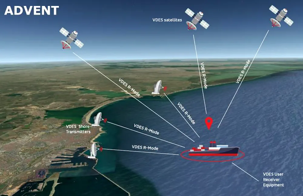
In the maritime sector, work is ongoing towards the identification and development of alternative PNT (positioning, navigation and timing) solutions, that is, solutions that are not wholly dependent on GNSS-based technologies. “The VHF data exchange system [VDES], is being considered as a source of alternative PNT [A-PNT] for maritime,” said Michael Turner of GMV NSL, ...
insidegnss.com

India To Introduce GNSS-Based Toll Collection System

The National Highways Authority of India (NHAI) invited expressions of interest from global innovators to develop a GNSS-based electronic toll collection system, as announced by the Ministry of Road Transport and Highways. This initiative aims to integrate the GNSS system within the existing FASTag framework through a hybrid model combining RFID and GNSS-based toll collection. ...
kashlem.com
LabSat Announces The Launch Of The LabSat 4 GNSS Simulator For Enhanced GNSS Testing

LabSat Announces The Launch Of The LabSat 4 GNSS Simulator For Enhanced GNSS Testing

LabSat has introduced the LabSat 4 GNSS Simulator, a GNSS test solution. This latest addition to the LabSat range is designed to meet the rigorous demands of modern GNSS signal testing, providing enhanced customization and precision. Key to LabSat 4 are its three RF channels, each configurable with up to 12-bit I&Q quantization and a ...
insidegnss.com

Pythagoras Launches Pointorama For Streamlined Point Cloud Management

Pythagoras has released Pointorama, a groundbreaking cloud-based platform designed to simplify point cloud management. The official launch took place at GeoBusiness 2024, which was held on 5-6 June in London. Pythagoras is a provider of innovative software solutions for land surveyors and contractors. In today’s rapidly evolving field of land surveying, the quest for efficiency ...
gim-international.com
TRISHNA Mission

TRISHNA Mission: Advancing High-Resolution Thermal Imaging For Climate And Resource Management

The TRISHNA (Thermal Infra-Red Imaging Satellite for High-resolution Natural Resource Assessment) mission, a collaborative endeavor between ISRO and CNES, is engineered to deliver high spatial and high temporal resolution monitoring of Earth’s surface temperature, emissivity, biophysical and radiation variables for surface energy budgeting at regional to global scale. This mission addresses critical water and food ...
isro.gov.in
How A ‘Citizen Map’ Is Helping Brazil Prepare For Next Big Flood

How A ‘Citizen Map’ Is Helping Brazil Prepare For Next Big Flood

In the wake of last month’s disastrous flooding in southern Brazil, researchers are asking residents to use their smartphone cameras to document the damage and high-water marks. The data collected will help scientists map flood risk and inform decisions on where to rebuild. When Lucas George Wendt arrived in Lajeado in late May, the water ...
e360.yale.edu
Researchers Unveil Most Detailed Map Of Water Bodies Across Qinghai-Xizang Plateau

Researchers Unveil Most Detailed Map Of Water Bodies Across Qinghai-Xizang Plateau

In a study published in Scientific Data, researchers from the Aerospace Information Research Institute of the Chinese Academy of Sciences unveiled the most detailed dataset to date, illuminating the complex network of water bodies sprawled across the Qinghai-Xizang Plateau. This dataset, openly available in figshare, paints a holistic picture by furnishing a high-resolution map of ...
phys.org
Shape And Depth Of Ocean Floor Profoundly Influence How Carbon Is Stored There

Shape And Depth Of Ocean Floor Profoundly Influence How Carbon Is Stored There

The movement of carbon between the atmosphere, oceans and continents — the carbon cycle — is a fundamental process that regulates Earth’s climate. Some factors, like volcanic eruptions or human activity, emit carbon dioxide into the atmosphere. Others, such as forests and oceans, absorb that CO2. In a well-regulated system, the right amount of CO2 ...
newsroom.ucla.edu
New NASA Mission To Map Earth’s Surface In 3D Moves One Step Closer

New NASA Mission To Map Earth’s Surface In 3D Moves One Step Closer

The Earth Dynamics Geodetic Explorer (EDGE)—a newly proposed NASA satellite mission to monitor the three-dimensional structure of global vegetation and ice—is one of four finalists selected for NASA’s next generation of Earth-observing satellites under the Earth System Explorers Program. The project, which includes Northern Arizona University assistant research professor Chris Hakkenberg as co-investigator and biodiversity ...
news.nau.edu
Study Reviews Current State Of Global Navigation Satellite System Reflectometry

Study Reviews Current State Of Global Navigation Satellite System Reflectometry

Global navigation satellite system reflectometry (GNSS-R) is emerging as a pivotal technology in remote sensing due to its ability to provide high-precision, real-time data under all weather conditions. Traditionally, the GNSS has been utilized for positioning, navigation, and timing. However, recent advancements have demonstrated its efficacy in environmental monitoring through scatterometry and reflectometry. GNSS-R capitalizes ...
phys.org
A New Google Maps Layer Shows Public Restrooms In NYC

A New Google Maps Layer Shows Public Restrooms In NYC

There’s no elegant way to say this: going to the bathroom in New York is a nightmare. Public restrooms in the city are hard to find and are often either out of order or require you to buy something at a store or café to be able to use. The problem is so bad that ...
theverge.com
Chinese Internet Giant Baidu To Provide Map Service For Tesla EVs, As US Carmaker Eyes Mainland Launch Of Self-Driving System

Chinese Internet Giant Baidu To Provide Map Service For Tesla EVs, As US Carmaker Eyes Mainland Launch Of Self-Driving System

Chinese internet search giant Baidu will provide Tesla with mapping software for its electric vehicles (EVs), paving the way for the US carmaker to launch its Full Self-Driving (FSD) system on the mainland. Version 20 of Baidu Maps, a desktop and mobile web-mapping application released in April, will soon be available on Tesla’s EVs, the ...
scmp.com