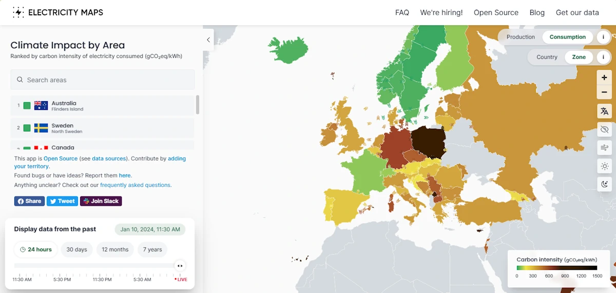
Geomaticians

English

Mapbox And Hyundai Autoever Collaborate On 3D Navigation With MapGPT

Mapbox And Hyundai Autoever Collaborate On 3D Navigation With MapGPT

Mapbox, a global company in location technology, announces its collaboration with Hyundai Autoever, an automotive software innovation leader of the Hyundai Motor Group. Together, Mapbox and Hyundai Autoever are set to redefine the driving experience by developing an AI-powered digital ecosystem centred around Mapbox MapGPT, a location-intelligent AI voice assistant capable of natural and actionable ...
geospatialworld.net
Septentrio Launches Antarx GNSS Smart Antenna For Machine Automation Applications

Septentrio Launches Antarx GNSS Smart Antenna For Machine Automation Applications

Septentrio has introduced the AntaRx smart antenna, catering to machine automation needs in industries such as construction, precision agriculture, and logistics. The smart antenna is housed in a rugged casing, designed to endure shocks and vibrations in challenging industrial environments. The multi-frequency receiver aims for high-accuracy RTK positioning down to the centimeter level. The AntaRx ...
insidegnss.com
Advanced Hour-Hectometer Hyperspectral Remote Sensing For Fine-Scale Atmospheric Emissions

Advanced Hour-Hectometer Hyperspectral Remote Sensing For Fine-Scale Atmospheric Emissions

A groundbreaking study by researchers from a number of institutions in China introduces a novel hyperspectral remote sensing technique capable of hour-hectometer level horizontal distribution of trace gases, offering an advanced tool to accurately identify emission sources. The study was published in the Journal of Remote Sensing on 14 November 2023. The research introduces a ...
phys.org
Progress In High-Resolution Vegetation Mapping China's Leap Toward Advanced Environmental Monitoring

Progress In High-Resolution Vegetation Mapping: China’s Leap Toward Advanced Environmental Monitoring

For a study published in the Journal of Remote Sensing, a team of scientists led by Xihan Mu from Beijing Normal University has made a leap forward in environmental monitoring and ecological research. They have created seamless maps of Fractional Vegetation Cover (FVC) over China at 30-meter resolution and semimonthly intervals, covering the years 2010-2020. ...
phys.org

Alberta Seeks Public Input On Updated Flood Maps, Even During A Drought

Even as Alberta prepares for a serious drought this spring, government officials continue to update flood mapping studies covering 1,600 kilometres of riverways. The province is asking for public feedback on 27 flood studies across the province, encompassing 600 kilometres of updated mapping and 1,000 kilometres of new mapping. “That’s more flood mapping we are ...
calgaryherald.com

IMD Launches Weather Forecast Portal For Farmers & MAUSAM App

New Delhi, Jan 15 (UNI) India Meteorological Department (IMD) on the 150th year of its establishment, on Monday launched the weather forecast portal ‘Panchayat Mausam Seva for farmers’ to support farmers with timely weather alerts and warnings for planning agricultural activities accordingly. “Through this portal, weather forecasts in English, Hindi and twelve regional languages will ...
uniindia.com

Seniors Living Near Urban Open Spaces Report Less Mental Distress, A Dementia Risk Factor

With widening research, doctors have even more reasons to tell patients to spend time in open spaces for better mental health. Now, a statewide study suggests even small differences in nearness to urban green spaces and access to waterfronts have ties to improved self-reported mental health among people 65 and older. Such proximity to open ...
spokesman.com

NGA Issues Million Dollar Challenge To Stop Illegal Fishing

The National Geospatial-Intelligence Agency (NGA) and the National Security Innovation Network (NSIN) are looking for people with innovative solutions to help stop illegal fishing. This new challenge has a million-dollar prize pool. Illegal, unreported and unregulated fishing is a critical issue threatening the sustainability of marine ecosystems. It contributes significantly to the decline and potential ...
fox2now.com
Researchers Use Spinning Metasurfaces To Craft Compact Thermal Imaging System

Researchers Use Spinning Metasurfaces To Craft Compact Thermal Imaging System

Researchers have developed a new technology that uses meta-optical devices to perform thermal imaging. The approach provides richer information about imaged objects, which could broaden the use of thermal imaging in fields such as autonomous navigation, security, thermography, medical imaging and remote sensing. “Our method overcomes the challenges of traditional spectral thermal imagers, which are ...
optica.org

New GISTDA App Warns Of Hot Spots To Reduce Wildfire Risks

The GISTDA is continuing to develop its application called FAIPA, “Forest Fire” in English, to notify hotspots at the sub-district, district, and provincial levels, using real-time or near real-time satellite data for primary users, including agencies like the Department of Disaster Prevention and Mitigation, volunteer groups, and local residents. The application provides nationwide hotspot data, ...
nationthailand.com
Newly Released Avian Data Monitoring Portal Available To Public And Researchers

Newly Released Avian Data Monitoring Portal Available To Public And Researchers

A newly released Avian Data Monitoring Portal brings together more than a decade of aerial survey photos along the northern Gulf of Mexico to provide an easily searchable database for researchers, natural resource managers, and the public. Found at avianmonitoring.com, the portal will help coastal managers, coastal restoration engineers, researchers, and others not only see ...
press-herald.com
Austin Peay Team Used Special Technology To Help Tennessee Tornado Victims

Austin Peay Team Used Special Technology To Help Tennessee Tornado Victims

It’s been one month since deadly tornadoes tore through Tennessee counties and left serious devastation. Since then, many have jumped in to help. One team — part of a data center at Austin Peay State University — used a special computer system to get assistance to victims faster. Mike Wilson, the director of the APSU ...
newschannel5.com
Mecklenburg County GIS Time Machine Going Forward By Seeing Where We’ve Been

Mecklenburg County GIS Time Machine: Going Forward By Seeing Where We’ve Been

Mecklenburg County Geospatial Information Services (GIS) is starting off 2024 by reflecting on our growth and tree canopy. The Mecklenburg County GIS Time Machine is a Historical Aerial Photo Viewer that allows the user to zoom into a location of interest and view land use changes over time through the display of historical aerial photography ...
news.mecknc.gov

NGA To Tap Commercial Satellite Data Under ‘Luno’ Program

The National Geospatial-Intelligence Agency (NGA) on Jan. 10 issued a solicitation for commercial satellite Earth observation data under a new program called Luno. The program aims to leverage commercial satellite imagery and data analytics to bolster NGA’s global monitoring capabilities, the agency said in the request for proposals. Submissions are due March 26. NGA officials ...
spacenews.com
New Research Reveals That Only 18 Percent Of Land Critical For Both Human Well-Being And Biodiversity Is Protected

New Research Reveals That Only 18 Percent Of Land Critical For Both Human Well-Being And Biodiversity Is Protected

A new study supported by One Earth and published in Nature Communications sheds light on a critical environmental issue: the balance between human well-being and biodiversity conservation. The research, conducted by an international team of researchers, reveals that conserving approximately half of the global land area is essential to maintain the majority of nature’s contributions ...
oneearth.org
This Website Will Help You Find The Best Driving Roads In The World

This Website Will Help You Find The Best Driving Roads In The World

The search for the perfect driving road never ends. Besides being a subjective matter, how does one even begin such a monumental task as seeking out roads around the world? Actually, it may not be as daunting as you think, thanks to this very cool website that not only highlights twisty roads, but delivers gobs ...
motor1.com
This US-Indian Satellite Will Monitor Earth’s Changing Frozen Regions

This US-Indian Satellite Will Monitor Earth’s Changing Frozen Regions

NISAR, the soon-to-launch radar satellite from NASA and the Indian Space Research Organisation (ISRO), will measure some key Earth vital signs, from the health of wetlands to ground deformation by volcanoes to the dynamics of land and sea ice. This last capability will help researchers decipher how small-scale processes can cause monumental changes in the ...
jpl.nasa.gov
Electricity Maps

Electricity Maps

A real time and historical visualisation of the Greenhouse Gas Intensity (in terms of CO2 equivalent) of electricity production and consumption around the world. This project aims to provide a free, open-source, and transparent visualisation of the carbon intensity of electricity consumption around the world.
electricitymaps.com

Geospatial Commission Highlights MUDDI Model For Subsurface Data

The Geospatial Commission has flagged up the development by the Open Geospatial Consortium (OGC) of a standard for data on subsurface features. It has been the first organisation to use the Model for Underground Data Definition and Integration (MUDDI) in its development of National Underground Asset Register (NUAR), which will provide a national data source ...
ukauthority.com
Satellites And AI Could Help Farmers Detect Soybean Aphid Infestations

Satellites And AI Could Help Farmers Detect Soybean Aphid Infestations

Satellite-based remote sensing allows us to see much more than we can see when standing on the ground. New research from the University of Minnesota found, when combined with artificial intelligence, remote sensing could dramatically improve management of soybean aphid, an invasive pest that negatively impacts soybean yield and quality. Published in the journal Crop ...
twin-cities.umn.edu
WisDOT interactive map shows where infrastructure funding is awarded

WisDOT Interactive Map Shows Where Infrastructure Funding Is Awarded

The Wisconsin Department of Transportation (WisDOT) announced it launched an interactive map and dashboard that will show where federal discretionary grants were awarded to municipalities across the state. As of Monday, the department said more than $888 million would come to Wisconsin for transportation projects in all corners of the state. “WisDOT is committed to ...
dailyreporter.com
Many Women Bypass Nearest Hospital for Breast Cancer Surgery

Many Women Bypass Nearest Hospital for Breast Cancer Surgery

Many women undergoing breast-conserving surgery (BCS) or mastectomy bypass their nearest hospitals, according to a study published online Jan. 8 in Cancer. Ajay Aggarwal, M.D., Ph.D., from the London School of Hygiene and Tropical Medicine, and colleagues used linked administrative datasets from the English National Health Service to identify all women who underwent BCS or ...
healthday.com
Calgary Researchers Using High-Tech Drones To Map Alberta First Nation

Calgary Researchers Using High-Tech Drones To Map Alberta First Nation

Researchers and students at the Southern Alberta Institute of Technology are using sophisticated drones to digitally map Frog Lake First Nation. The nation, about 260 kilometres northeast of Edmonton, has relied on paper and low-resolution digital maps that no longer represent the community, according to the research team. “Maps are incredibly dynamic. They change quite ...
cbc.ca
The Sound Maps That Predict Poachers' Movements

The Sound Maps That Predict Poachers’ Movements

In the Upper Paraná Atlantic Forest lies the world-renowned Iguazu Falls. On one side of the towering cascades is the Iguazú National Park of Argentina, on the other is the Iguaçu National Park of Brazil. Greened by over 2,000 plant species, the landscape is home to an array of creatures, including the charismatic jaguar. And ...
bbc.com

Digital Demarcation Of Deemed Forests Begins In Delhi

The Delhi government has identified and is in the process of digitally demarcating over 2,000 hectares of land and over 450km of roads and drains as deemed forests, the state forest department has said in an affidavit submitted to the Delhi high court last month. A deemed forest is not a notified or a reserve ...
hindustantimes.com

Croatia’s National Map Of Maritime Habitats Launched

This marked the culmination of the project “Mapping Coastal and Submarine Habitats in the Adriatic Sea under National Jurisdiction,” spearheaded by the Ministry of Economy and Sustainable Development of the Republic of Croatia (MINGOR) in collaboration with a consortium of over 200 experts. Institute of Oceanography and Fisheries said that the project aimed to enhance ...
croatiaweek.com
Study From NYC To D.C. And Beyond, Cities On The East Coast Are Sinking

Study: From NYC To D.C. And Beyond, Cities On The East Coast Are Sinking

Major cities on the U.S. Atlantic coast are sinking, in some cases as much as 5 millimeters per year – a decline at the ocean’s edge that well outpaces global sea level rise, confirms new research from Virginia Tech and the U.S. Geological Survey. Particularly hard hit population centers such as New York City and ...
news.vt.edu
How Artificial Intelligence Can Help Beavers Fight Floods, Droughts And Wildfires

How Artificial Intelligence Can Help Beavers Fight Floods, Droughts And Wildfires

A few years ago, a couple of Google employees reached out to a Minnesota scientist with an unusual proposal: What if they could teach computers to spot beaver habitats from space? “They wanted to know if I thought it was possible to find beaver wetlands from aerial imagery myself, and then if that could be ...
cbc.ca
World’s First Map Of Industrial Ocean Use

World’s First Map Of Industrial Ocean Use

Illegal fishing practices through spoofing tracking devices in ships have become a common practice in the industrial use of our oceans. A new study published in the journal Nature corroborates the trend and offers a view of the changing oceanic activities and landscape. Led by Global Fishing Watch, a company founded by Google, the study ...
geospatialworld.net