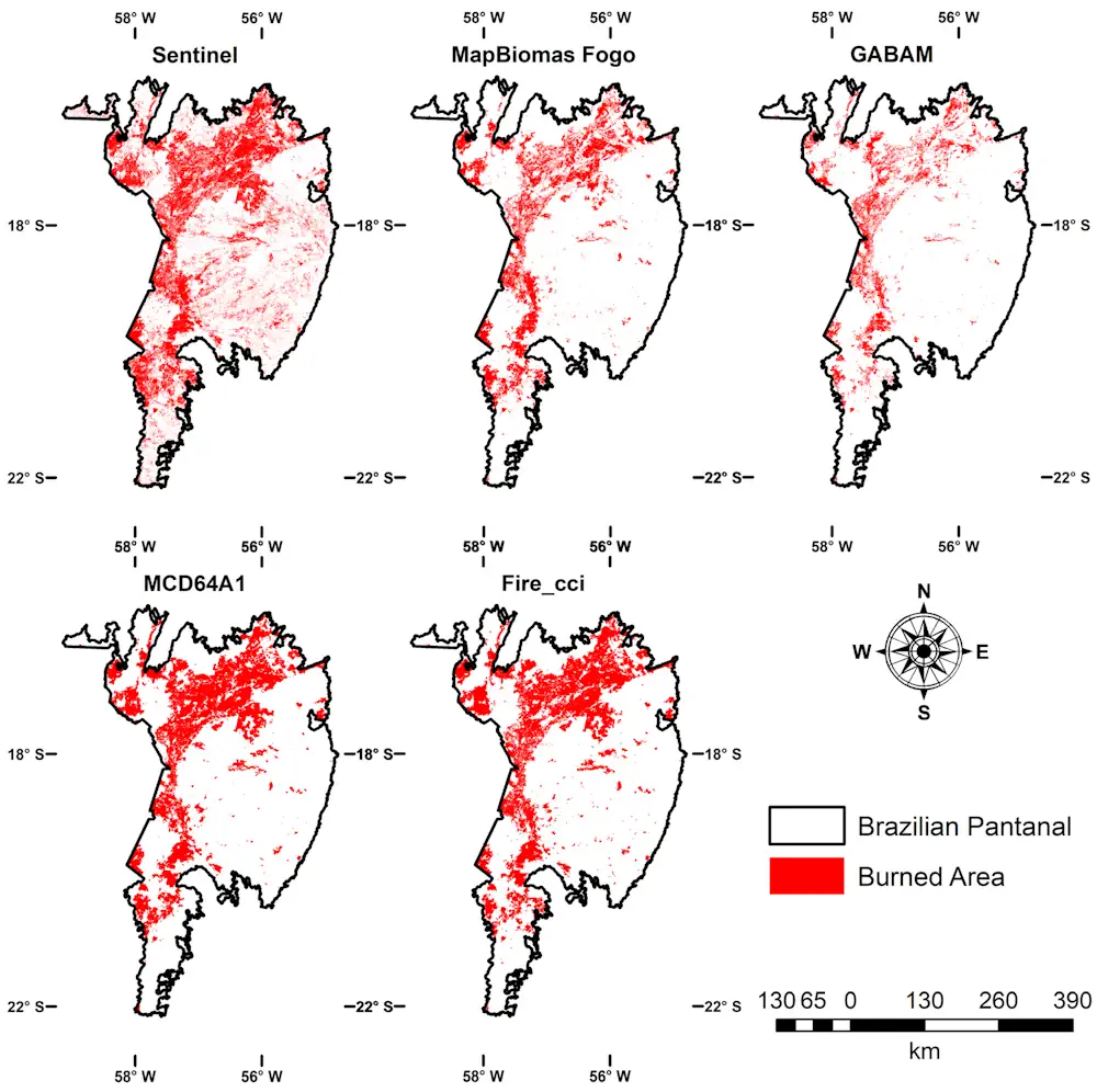
In 2020, the Pantanal, the largest tropical freshwater wetland in the world and a biodiversity hotspot, was swept by high-intensity fires that destroyed native vegetation in an area totaling 44,998 square kilometers (km²), or about 30% of the Brazilian portion of the biome, which spans some 150,000 km². The estimate is presented in an article published in the science journal Fire. The area destroyed by that year’s disastrous fires was far larger than had been thought, according to the article. Previous estimates ranged from 14,307 km² to 36,017 km². Led by scientists at the National Space Research Institute (INPE) in Brazil, the study included construction of a model based on satellite images from the European Space Agency’s SENTINEL-2 satellite, which was shown to estimate regional-scale burned areas with significantly greater precision and accuracy than other satellite-based models for the Pantanal.
The approach used in the study achieved 96% accuracy, and the results “will help to improve estimates of trace gases and aerosols associated with biomass burning”, the authors note, adding that “global biomass burning inventories are widely known for having biases at a regional scale”. The findings highlight the need for approaches that better assess the influence of fire on ecosystems and biodiversity in regions critically sensitive to climate change, such as the Pantanal. Their importance is all the greater in light of the strength of this year’s El Niño, which could make the northern portion of the Pantanal and adjacent areas in the Upper Paraguay Basin drier and more susceptible to fire.
“The results of the study don’t show one model or product to be better than another. Every method has its own strengths and limitations. Estimates tend to vary significantly as a result. However, the images furnished by the MSI [Multispectral Instrument] on board SENTINEL-2 have two positive points: spatial resolution is 20 meters, providing much better detail of burned areas; and temporal resolution, very important to this type of study, is 5 days, compared with a revisit frequency of up to 16 days for the Landsats,” said forest engineer Andeise Cerqueira Dutra, penultimate author of the article and a PhD candidate at INPE’s Earth Observation and Geoinformatics Division (DIOTG), with Yosio Edemir Shimabukuro as thesis advisor.
For Mataveli, it is important to refine this type of analysis and obtain regional-scale estimates in order not only to estimate burned areas more accurately but also to calculate greenhouse gas emissions, which directly affect climate change. “Finding ways to improve these products and generate more accurate data is very important for society. An example is the pilot project launched this year in the Pantanal, also using remote sensing data to identify areas affected by fire and estimate the accumulation of combustible matter. Managers of environmental agencies and firefighters can use these findings to manage fire in an integrated manner, defining priority areas and actions to combat or control fires,” Dutra said.